File:Proposed thoroughfare plan for Seattle central business district, 1959.jpg
Jump to navigation
Jump to search
Size of this preview: 415 × 600 pixels. Other resolutions: 166 × 240 pixels | 332 × 480 pixels | 531 × 768 pixels | 709 × 1,024 pixels | 2,260 × 3,265 pixels.
Original file (2,260 × 3,265 pixels, file size: 1.12 MB, MIME type: image/jpeg)
Captions
Captions
Add a one-line explanation of what this file represents
Summary[edit]
| Description |
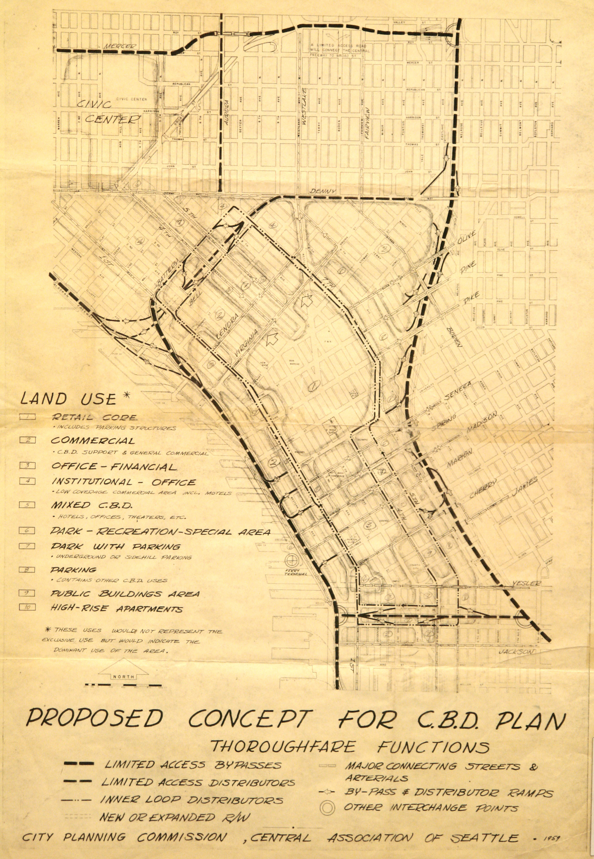
English: Proposed thoroughfare plan for Seattle central business district, 1959. Other than Interstate 5 and the already then extant SR-99, relatively little of this was put into effect. Map 1160, Seattle Municipal Archives. |
||||||||||||||||||||
| Date | 1959; Flickr upload 2007-11-19 11:06 | ||||||||||||||||||||
| Source |
Proposed thoroughfare plan for central business district, 1959
This image comes from the Seattle Municipal Archives, via Flickr.
|
||||||||||||||||||||
| Author | Seattle City Planning Commission, Central Association of Seattle, Seattle Municipal Archives from Seattle, WA | ||||||||||||||||||||
.jpg)
| Camera location | | View this and other nearby images on: OpenStreetMap |
|---|
Licensing[edit]
This file is licensed under the Creative Commons Attribution 2.0 Generic license.
- You are free:
- to share – to copy, distribute and transmit the work
- to remix – to adapt the work
- Under the following conditions:
- attribution – You must give appropriate credit, provide a link to the license, and indicate if changes were made. You may do so in any reasonable manner, but not in any way that suggests the licensor endorses you or your use.
| This image, originally posted to Flickr, was reviewed on July 15, 2010 by the administrator or reviewer File Upload Bot (Magnus Manske), who confirmed that it was available on Flickr under the stated license on that date. |
| Annotations | This image is annotated: View the annotations at Commons |
File history
Click on a date/time to view the file as it appeared at that time.
| Date/Time | Thumbnail | Dimensions | User | Comment | |
|---|---|---|---|---|---|
| current | 22:02, 15 July 2010 | | 2,260 × 3,265 (1.12 MB) | File Upload Bot (Magnus Manske) (talk | contribs) | {{Information |Description=[http://clerk.ci.seattle.wa.us/~scripts/nph-brs.exe?s1=1160&S2=&S3=&l=20&Sect6=HITOFF&Sect5=MAPS1&Sect4=AND&d=MAPS&p=1&u=/~public/maps1.htm&r=1&f=G Map 1160], [http://www.seattle.gov/CityArchives/ Seattle Municipal Archives]. |S |
You cannot overwrite this file.
File usage on Commons
The following page uses this file: