File:Primer Viaje de Colon Detalle.svg
Jump to navigation
Jump to search

Size of this PNG preview of this SVG file: 533 × 306 pixels. Other resolutions: 320 × 184 pixels | 640 × 367 pixels | 1,024 × 588 pixels | 1,280 × 735 pixels | 2,560 × 1,470 pixels.
Original file (SVG file, nominally 533 × 306 pixels, file size: 44 KB)
Captions
Captions
Add a one-line explanation of what this file represents
Summary[edit]
| Description |
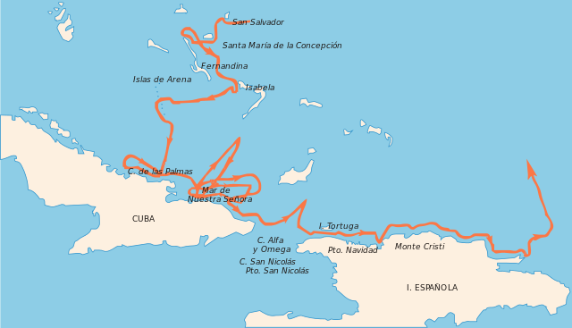
English: Map showing the first voyage of Christopher Columbus (1492−1493) in the Caribbean.
Español: Mapa del primer viaje de Cristóbal Colón en formato de vector con nombres de lugares en Español. Incluye más detalle que el mapa SVG del primer viaje de Colón ya existente. |
| Source | http://losviajesdecristobalcolon.blogspot.com/ |
| Author | SVET, Yákov |
| Other versions | Primer_viaje_de_Colón.svg |
Converted to SVG from an existing JPG (http://losviajesdecristobalcolon.blogspot.com/) and other sources. Original JPG isn't attributed in the source web site and information depicted is public domain.
Licensing[edit]
| This file is made available under the Creative Commons CC0 1.0 Universal Public Domain Dedication. | |
| The person who associated a work with this deed has dedicated the work to the public domain by waiving all of their rights to the work worldwide under copyright law, including all related and neighboring rights, to the extent allowed by law. You can copy, modify, distribute and perform the work, even for commercial purposes, all without asking permission.
|
File history
Click on a date/time to view the file as it appeared at that time.
| Date/Time | Thumbnail | Dimensions | User | Comment | |
|---|---|---|---|---|---|
| current | 21:44, 29 September 2009 | | 533 × 306 (44 KB) | Zootie (talk | contribs) | Reverted to version as of 21:38, 29 September 2009 |
| 21:44, 29 September 2009 |  | 990 × 569 (42 KB) | Zootie (talk | contribs) | More bounding box | |
| 21:38, 29 September 2009 |  | 533 × 306 (44 KB) | Zootie (talk | contribs) | Still dealing with the bounding box | |
| 21:22, 29 September 2009 |  | 165 × 95 (53 KB) | Zootie (talk | contribs) | Changed canvas size | |
| 21:16, 29 September 2009 |  | 765 × 990 (42 KB) | Zootie (talk | contribs) | {{Information |Description={{en|1=Map showing Colombus first trip in vector format using spanish language labels for locales. Includes more landmarks than existing SVG map of Colombus' first trip.}} {{es|1=Mapa del primer viaje de Cristóbal Colón en for |
You cannot overwrite this file.
File usage on Commons
There are no pages that use this file.