File:Pre-eruption Pinatubo.jpg

Pre-eruption_Pinatubo.jpg (500 × 334 pixels, file size: 69 KB, MIME type: image/jpeg)
Captions
Captions
| Description |
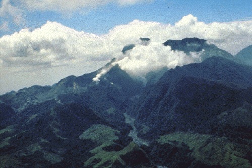
Mount Pinatubo in April 1991, before the onset of magmatic eruptions. Preeruption Mount Pinatubo, April 16, 1991. View from the northwest, up the Maraunot River valley. The river had become acidic and silty, owing to reactivation of the hydrothermal system and phreatic explosions of April 2, 1991 (the vents of which were just out of view at left edge of photograph). Steam was from 2-week-old fumaroles on the upper north slope of the volcano. The fumarole farthest to the right (behind a jagged ridge, right of the one visible on the valley floor) would later become the site of the preclimactic lava dome extrusion of June 7-12 (Hoblitt, Wolfe, and others, this volume). Mount Negron is behind and to the right of Pinatubo. (R.S. Punongbayan) |
| Date | |
| Source | Figure 2A on Photographic Record of Rapid Geomorphic Change at Mount Pinatubo, 1991-94 |
| Author | United States Geological Survey |
This image is in the public domain in the United States because it only contains materials that originally came from the United States Geological Survey, an agency of the United States Department of the Interior. For more information, see the official USGS copyright policy.
|
File history
Click on a date/time to view the file as it appeared at that time.
| Date/Time | Thumbnail | Dimensions | User | Comment | |
|---|---|---|---|---|---|
| current | 18:57, 12 October 2005 | | 500 × 334 (69 KB) | Ascánder (talk | contribs) | Mount Pinatubo in April 1991, before the onset of magmatic eruptions. (Probable) source: [http://pubs.usgs.gov/pinatubo/punong1/fig2a.jpg Fig.2A] on [http://pubs.usgs.gov/pinatubo/punong1/index.html] {{PD-USGov-Interior-USGS}} [[Category:Philippines] |
You cannot overwrite this file.
File usage on Commons
There are no pages that use this file.
File usage on other wikis
The following other wikis use this file:
- Usage on az.wikipedia.org
- Usage on bg.wikipedia.org
- Usage on cs.wikipedia.org
- Usage on en.wikipedia.org
- Usage on es.wikipedia.org
- Usage on fi.wikipedia.org
- Usage on fr.wikipedia.org
- Usage on he.wikipedia.org
- Usage on hy.wikipedia.org
- Usage on io.wikipedia.org
- Usage on it.wikipedia.org
- Usage on ja.wikipedia.org
- Usage on ka.wikipedia.org
- Usage on kk.wikipedia.org
- Usage on lt.wikipedia.org
- Usage on nl.wikipedia.org
- Usage on no.wikipedia.org
- Usage on pam.wikipedia.org
- Usage on pl.wikipedia.org
- Usage on ru.wikipedia.org
- Usage on sk.wikipedia.org
- Usage on sr.wikipedia.org