File:Prague's trolleybus system map.svg
Jump to navigation
Jump to search

Size of this PNG preview of this SVG file: 800 × 495 pixels. Other resolutions: 320 × 198 pixels | 640 × 396 pixels | 1,024 × 634 pixels | 1,280 × 792 pixels | 2,560 × 1,585 pixels | 2,100 × 1,300 pixels.
Original file (SVG file, nominally 2,100 × 1,300 pixels, file size: 77 KB)
Captions
Captions
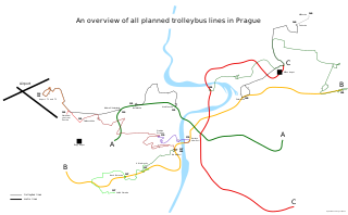
Prague's proposed trolleybus system map
Summary[edit]
| Description |
Čeština: Schéma linek navrhovaného trolejbusového systému v Praze.
English: A scheme of proposed trolleybus lines in Prague. |
| Date | |
| Source | Own work |
| Author | Zubozrout |
| Permission (Reusing this file) |
I, the copyright holder of this work, hereby publish it under the following license: This file is licensed under the Creative Commons Attribution-Share Alike 4.0 International license.
|
File history
Click on a date/time to view the file as it appeared at that time.
| Date/Time | Thumbnail | Dimensions | User | Comment | |
|---|---|---|---|---|---|
| current | 09:18, 5 August 2021 | | 2,100 × 1,300 (77 KB) | Zubozrout (talk | contribs) | Added a newly planned line 201, as per https://ct24.ceskatelevize.cz/regiony/3339694-z-holesovic-na-cerny-most-v-praze-budou-jezdit-elektrobusy |
| 07:21, 4 July 2020 |  | 2,100 × 1,300 (108 KB) | Zubozrout (talk | contribs) | Modified design to be hopefully a bit easier to look at, fixed arrow pointing to a wrong direction on the Bořislavka end of line 131, fixed missing part of the 137 route at the Na Knížecí terminus. | |
| 07:45, 25 June 2020 |  | 2,100 × 1,300 (103 KB) | Zubozrout (talk | contribs) | Slight layout updates - fixed routing of line 140, added missing arrow to the Jinonice section of line 137, labels moved outside metro lines where feasible and required for readability issues. | |
| 07:39, 25 June 2020 |  | 2,100 × 1,300 (101 KB) | Zubozrout (talk | contribs) | Added metro lines, different shade to the end section of line 140, legend - map size enlarged a bit to allow for adding in the whole metro lines B and C. | |
| 21:46, 24 June 2020 |  | 1,920 × 1,200 (48 KB) | Zubozrout (talk | contribs) | Added white background and 2 missing arrows for line 131. | |
| 21:38, 24 June 2020 |  | 1,920 × 1,200 (46 KB) | Zubozrout (talk | contribs) | Uploaded own work with UploadWizard |
You cannot overwrite this file.
File usage on Commons
The following 4 pages use this file:
File usage on other wikis
The following other wikis use this file:
- Usage on de.wikipedia.org
- Usage on ja.wikipedia.org