File:Potsdam Spandau Bahn Wasser.png
Jump to navigation
Jump to search

Size of this preview: 551 × 599 pixels. Other resolutions: 221 × 240 pixels | 441 × 480 pixels | 706 × 768 pixels | 941 × 1,024 pixels | 1,400 × 1,523 pixels.
Original file (1,400 × 1,523 pixels, file size: 919 KB, MIME type: image/png)
Captions
Captions
Add a one-line explanation of what this file represents
| Description |
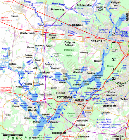
Deutsch: Wasser- und Schienenwege um Potsdam und Berlin-Spandau English: Waterways and Railways around Potsdam and Berlin-Spandau |
|||||||||||||||
| Date | ||||||||||||||||
| Source |
|
|||||||||||||||
| Author | Ulamm (talk) | |||||||||||||||
| Other versions |
|
File history
Click on a date/time to view the file as it appeared at that time.
| Date/Time | Thumbnail | Dimensions | User | Comment | |
|---|---|---|---|---|---|
| current | 10:16, 12 May 2016 | | 1,400 × 1,523 (919 KB) | Ulamm (talk | contribs) | details |
| 08:50, 12 May 2016 |  | 1,400 × 1,523 (919 KB) | Ulamm (talk | contribs) | name: Alter GHHK | |
| 22:47, 6 May 2016 |  | 1,400 × 1,523 (918 KB) | Ulamm (talk | contribs) | SchönXwalde | |
| 13:27, 6 May 2016 |  | 1,400 × 1,523 (918 KB) | Ulamm (talk | contribs) | + water management | |
| 21:14, 4 May 2016 |  | 1,400 × 1,523 (916 KB) | Ulamm (talk | contribs) | closed Potsdam Pirschheide (former Main) upper station; Heiligensee lake & Berlin suburb | |
| 22:35, 2 May 2016 |  | 1,400 × 1,523 (923 KB) | Ulamm (talk | contribs) | some more names | |
| 16:03, 2 May 2016 |  | 1,400 × 1,523 (921 KB) | Ulamm (talk | contribs) | some more courses of water, some more villages | |
| 00:45, 2 May 2016 |  | 1,400 × 1,523 (917 KB) | Ulamm (talk | contribs) | targets of ralway lines | |
| 21:06, 1 May 2016 |  | 1,400 × 1,523 (916 KB) | Ulamm (talk | contribs) | {{Information |Description={{de|Wassser-und Schienenwege um Potsdam und Berlin-Spandau}}{{en|Waterways and Railways around Potsdam and Berlin-Spandau}} |Source={{openstreetmap}} and {{own}} |Date=2016-05-01 |Author=~~~ |Permission= |other_versions=sma... |
You cannot overwrite this file.
File usage on Commons
The following 9 pages use this file:
- Havel
- User:Chumwa/OgreBot/Potential transport maps/2016 May 1-10
- User:Chumwa/OgreBot/Potential transport maps/2016 May 11-20
- User:Chumwa/OgreBot/Transport Maps/2016 May 1-10
- User:Chumwa/OgreBot/Transport Maps/2016 May 11-20
- User:Chumwa/OgreBot/Travel and communication maps/2016 May 1-10
- User:Chumwa/OgreBot/Travel and communication maps/2016 May 11-20
- User:Nordlicht8/Rail Germany/2016 May 1-10
- User:Nordlicht8/Rail Germany/2016 May 11-20
File usage on other wikis
The following other wikis use this file:
- Usage on de.wikipedia.org