File:Potomac watershed.png
Jump to navigation
Jump to search
No higher resolution available.
Potomac_watershed.png (500 × 500 pixels, file size: 176 KB, MIME type: image/png)
Captions
Captions
Add a one-line explanation of what this file represents
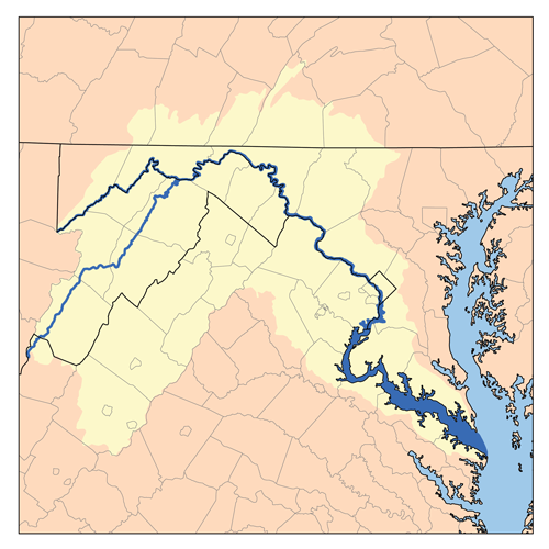
| Description | Map showing the Potomac River drainage basin. |
| Date | |
| Source | Own work, based on USGS data. |
| Author | Kmusser |
| Other versions | File:Potomacwatershedmap.png |
I, the copyright holder of this work, hereby publish it under the following license:
This file is licensed under the Creative Commons Attribution-Share Alike 3.0 Unported license.
- You are free:
- to share – to copy, distribute and transmit the work
- to remix – to adapt the work
- Under the following conditions:
- attribution – You must give appropriate credit, provide a link to the license, and indicate if changes were made. You may do so in any reasonable manner, but not in any way that suggests the licensor endorses you or your use.
- share alike – If you remix, transform, or build upon the material, you must distribute your contributions under the same or compatible license as the original.
File history
Click on a date/time to view the file as it appeared at that time.
| Date/Time | Thumbnail | Dimensions | User | Comment | |
|---|---|---|---|---|---|
| current | 16:59, 14 May 2007 | | 500 × 500 (176 KB) | Kmusser (talk | contribs) | increased resolution |
| 18:52, 16 November 2005 |  | 200 × 200 (13 KB) | Kmusser (talk | contribs) | ||
| 15:27, 8 September 2005 |  | 200 × 200 (49 KB) | Kmusser (talk | contribs) | ||
| 19:41, 2 August 2005 |  | 200 × 200 (20 KB) | Kmusser (talk | contribs) | This is a map of the Potomac River Watershed. I, Karl Musser, created it based on USGS data. {{GFDL}} |
You cannot overwrite this file.
File usage on Commons
The following page uses this file:
File usage on other wikis
The following other wikis use this file:
- Usage on ar.wikipedia.org
- Usage on azb.wikipedia.org
- Usage on bg.wikipedia.org
- Usage on bn.wikipedia.org
- Usage on cv.wikipedia.org
- Usage on en.wikipedia.org
- Usage on eo.wikipedia.org
- Usage on es.wikipedia.org
- Usage on fr.wikipedia.org
- Usage on fy.wikipedia.org
- Usage on id.wikipedia.org
- Usage on it.wikipedia.org
- Usage on ja.wikipedia.org
- Usage on ky.wikipedia.org
- Usage on nl.wikipedia.org
- Usage on no.wikipedia.org
- Usage on pl.wikipedia.org
- Usage on pt.wikipedia.org
- Usage on ro.wikipedia.org
- Usage on ru.wikipedia.org
- Usage on sl.wikipedia.org
- Usage on sw.wikipedia.org
- Usage on tr.wikipedia.org
- Usage on uk.wikipedia.org
- Usage on vi.wikipedia.org