File:Potomac River Water Gaps Harpers Ferry w compass and pointer.jpg
Jump to navigation
Jump to search

Size of this preview: 800 × 530 pixels. Other resolutions: 320 × 212 pixels | 640 × 424 pixels | 849 × 562 pixels.
Original file (849 × 562 pixels, file size: 143 KB, MIME type: image/jpeg)
Captions
Captions
Add a one-line explanation of what this file represents
Summary[edit]
| Description |
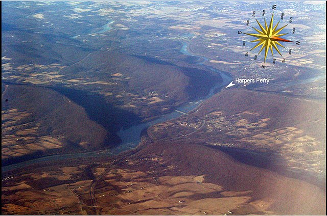
English: Description by Jstuby: " Oblique air photo of the Potomac River flowing through water gaps in the Blue Ridge Mountains. Virginia on the left, Maryland on the right, West Virginia in upper right, including Harpers Ferry (partially obscured by Maryland Heights) at the confluence of the Potomac and Shenandoah Rivers, and Charles Town at top. U.S. Route 340 runs westward up the middle of the photograph, from Brunswick, Maryland to Charles Town. Facing southwest. Taken Jan 17, 2009. Light color at right is glare on airplane window glass." |
| Date | |
| Source | File:Potomac_River_Water_Gaps_Harpers_Ferry.jpg |
| Author | Jstuby on English Wikipedia |
Note: Compass and marker indicating the location of Harpers Ferry were added by P999.
Licensing[edit]
| This file is made available under the Creative Commons CC0 1.0 Universal Public Domain Dedication. | |
| The person who associated a work with this deed has dedicated the work to the public domain by waiving all of their rights to the work worldwide under copyright law, including all related and neighboring rights, to the extent allowed by law. You can copy, modify, distribute and perform the work, even for commercial purposes, all without asking permission.
|
File history
Click on a date/time to view the file as it appeared at that time.
| Date/Time | Thumbnail | Dimensions | User | Comment | |
|---|---|---|---|---|---|
| current | 16:09, 23 February 2018 | | 849 × 562 (143 KB) | P999 (talk | contribs) | User created page with UploadWizard |
You cannot overwrite this file.
File usage on Commons
There are no pages that use this file.
File usage on other wikis
The following other wikis use this file:
- Usage on ar.wikipedia.org
- Usage on en.wikipedia.org