File:Potok Służewiecki - mapa 2.png
Jump to navigation
Jump to search
No higher resolution available.
Potok_Służewiecki_-_mapa_2.png (420 × 205 pixels, file size: 34 KB, MIME type: image/png)
Captions
Captions
Add a one-line explanation of what this file represents
| Open this image as an overlay in Google Earth (Google Maps, Bing) | (Help|Source) |
Summary[edit]
| Description |
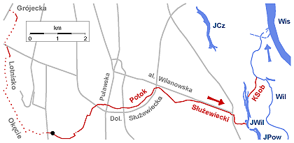
Polski: Potok Służewiecki i Kanał Sobieskiego (czerwona linia) na tle konturu Warszawy. Oznaczenia: • • • kanał zamknięty ● początek Potoku Służewieckiego wg Państwowego Rejestru Nazw Geograficznych (PRNG)*1 JWil - Jeziorko Wilanowskie KSob - Kanał Sobieskiego (uważany często z końcowy odcinek Potoku Służewieckiego) Wil - Wilanówka Wis - Wisła JPow - Jeziorko Powsinkowskie JCz - Jeziorko Czerniakowskie. Kanał zamknięty głównie na podstawie: Mariusz Barszcz. Zastosowanie modelu Santa Barbara Unit Hydrograph do symulacji hydrogramu przepływów w zlewniach zurbanizowanych. „Przegląd Geograficzny”. 86 (3), s. 381-391, 2014. DOI: 10.7163/PrzG.2014.3.5. Zasadnicza część mapki wykonana przy pomocy programu GMT5 *1 Według niektórych częściowo nieco nieaktualnych już map również mniej więcej w tym punkcie zaczyna się odkryty odcinek potoku. |
| Date | |
| Source | Own work |
| Author | Darekk2 |
Licensing[edit]
I, the copyright holder of this work, hereby publish it under the following license:
This file is licensed under the Creative Commons Attribution-Share Alike 4.0 International license.
- You are free:
- to share – to copy, distribute and transmit the work
- to remix – to adapt the work
- Under the following conditions:
- attribution – You must give appropriate credit, provide a link to the license, and indicate if changes were made. You may do so in any reasonable manner, but not in any way that suggests the licensor endorses you or your use.
- share alike – If you remix, transform, or build upon the material, you must distribute your contributions under the same or compatible license as the original.
File history
Click on a date/time to view the file as it appeared at that time.
| Date/Time | Thumbnail | Dimensions | User | Comment | |
|---|---|---|---|---|---|
| current | 19:07, 22 September 2016 | | 420 × 205 (34 KB) | Darekk2 (talk | contribs) | aktualizacja położenia źródła wg PRNG |
| 00:23, 29 January 2015 |  | 420 × 205 (34 KB) | Darekk2 (talk | contribs) | dodanie zgubionego podpisu Kanału Sobiekiego ... | |
| 23:29, 28 January 2015 |  | 420 × 205 (34 KB) | Darekk2 (talk | contribs) | mniej schematycznie odcinki kryte | |
| 08:35, 28 January 2015 |  | 420 × 207 (35 KB) | Darekk2 (talk | contribs) | przywrócenie czarnej kropki tylko | |
| 07:52, 28 January 2015 |  | 420 × 207 (35 KB) | Darekk2 (talk | contribs) | przesunięcie nazwy Puławska ... | |
| 07:47, 28 January 2015 |  | 420 × 207 (35 KB) | Darekk2 (talk | contribs) | przesunięcie nazwy Puławska | |
| 07:42, 28 January 2015 |  | 420 × 207 (35 KB) | Darekk2 (talk | contribs) | dodanie nazwy Puławska | |
| 15:09, 27 January 2015 |  | 420 × 207 (34 KB) | Darekk2 (talk | contribs) | tylko zaznaczenie początku potoku kropką | |
| 14:28, 27 January 2015 |  | 420 × 207 (34 KB) | Darekk2 (talk | contribs) | zaznaczenie fragmentów krytych, dodanie początku przy Grójeckiej, nazw Grójecka i Lotnisko Okęcie | |
| 10:20, 23 January 2015 |  | 420 × 175 (28 KB) | Darekk2 (talk | contribs) | dodanie nazw ulic, zbiorników wodnych, zmiana koloru wody |
You cannot overwrite this file.
File usage on Commons
There are no pages that use this file.
File usage on other wikis
The following other wikis use this file:
- Usage on pl.wikipedia.org