File:Post-medieval , Gunflint (FindID 707215).jpg
Jump to navigation
Jump to search
Size of this preview: 800 × 379 pixels. Other resolutions: 320 × 152 pixels | 640 × 303 pixels | 1,024 × 485 pixels | 1,280 × 607 pixels | 3,700 × 1,754 pixels.
Original file (3,700 × 1,754 pixels, file size: 2.43 MB, MIME type: image/jpeg)
Captions
Captions
Add a one-line explanation of what this file represents
Summary[edit]
.jpg&action=edit§ion=1)
| Post-medieval : Gunflint | |||
|---|---|---|---|
| Photographer |
York Museums Trust, Rebecca Griffiths, 2015-03-11 09:44:11 |
||
| Title |
Post-medieval : Gunflint |
||
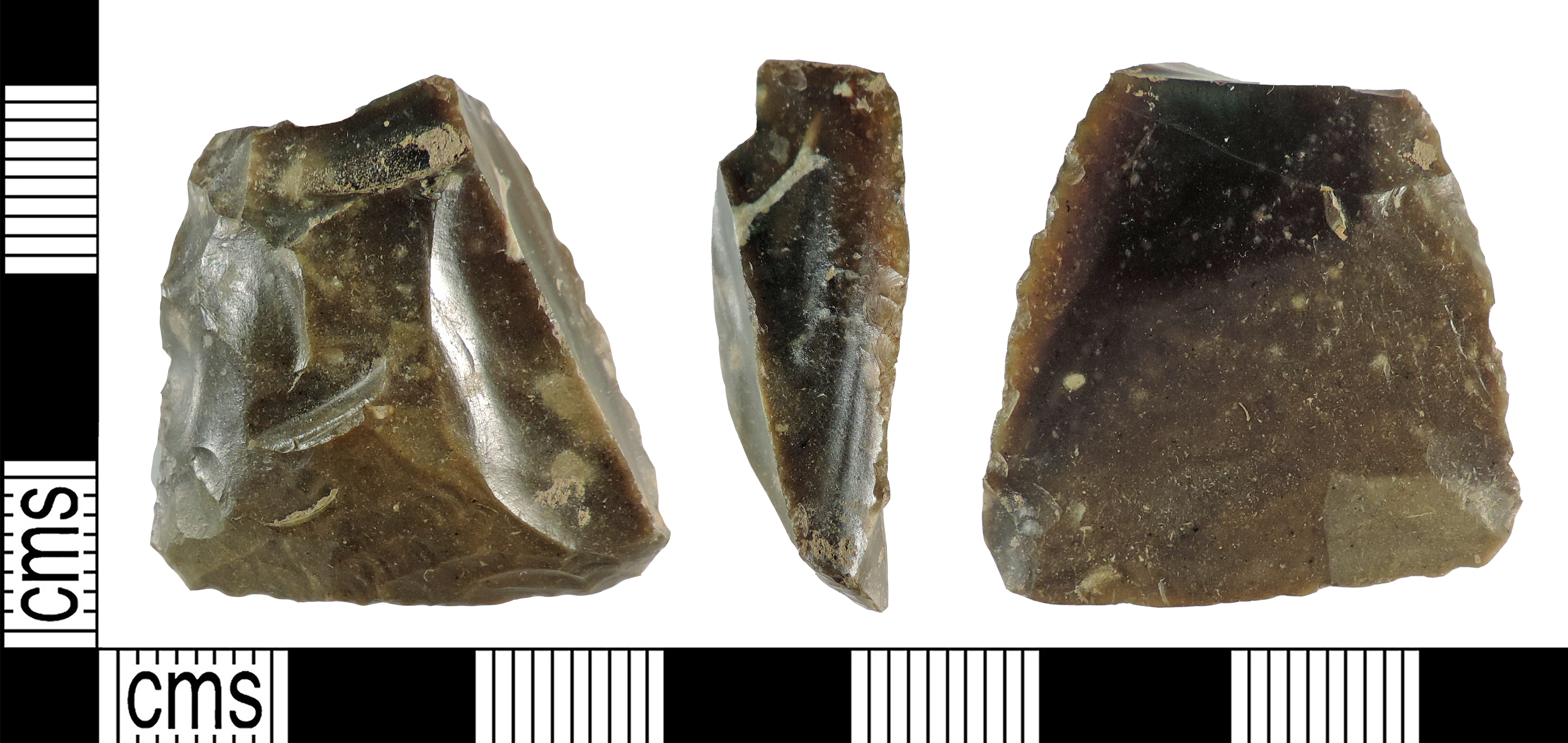
| Description |
English: A knapped gun-flint from a flintlock musket of post-medieval to modern date. The flint is rectangular in both shape and cross-section though the section is irregular and tapers from one end to the other. The flint is dark blackish-brown in colour with some lighter inclusions.
The object is 28.6mm long, 27.8mm wide, 9.6mm thick and weighs 8.3g. The flintlock was introduced in the middle of the 16th century and became the main regulation firearm for the British Army during the reign of William III. The knapped flint was used within the musket mechanism to produce a spark and could last between 20-25 shots before it had to be replaced. |
||
| Depicted place | (County of findspot) East Riding of Yorkshire | ||
| Date | between 1500 and 1800 | ||
| Accession number |
FindID: 707215 Old ref: YORYM-DC3016 Filename: DRH0082.jpg |
||
| Credit line |
|
||
| Source |
https://finds.org.uk/database/ajax/download/id/508703 Catalog: https://finds.org.uk/database/images/image/id/508703/recordtype/artefacts archive copy at the Wayback Machine Artefact: https://finds.org.uk/database/artefacts/record/id/707215 |
||
| Permission (Reusing this file) |
Attribution License version 2.0 (verified 15 November 2020) | ||
| Object location | | View this and other nearby images on: OpenStreetMap |
|---|
.jpg¶ms=053.791200_N_-000.535588_E_globe:Earth_class:object_type:object__&language=en)
Licensing[edit]
.jpg&action=edit§ion=2)
This file is licensed under the Creative Commons Attribution 2.0 Generic license.
Attribution: York Museums Trust
- You are free:
- to share – to copy, distribute and transmit the work
- to remix – to adapt the work
- Under the following conditions:
- attribution – You must give appropriate credit, provide a link to the license, and indicate if changes were made. You may do so in any reasonable manner, but not in any way that suggests the licensor endorses you or your use.
File history
Click on a date/time to view the file as it appeared at that time.
| Date/Time | Thumbnail | Dimensions | User | Comment | |
|---|---|---|---|---|---|
| current | 18:48, 27 February 2019 | | 3,700 × 1,754 (2.43 MB) | Fæ (talk | contribs) | Portable Antiquities Scheme, YORYM, FindID: 707215, post medieval, page 6845, batch count 6429 |
You cannot overwrite this file.
File usage on Commons
The following page uses this file:
.jpg)
.jpg&oldid=652754617)