File:Possible Aurora Mooring Sites.jpg
Jump to navigation
Jump to search
No higher resolution available.
Possible_Aurora_Mooring_Sites.jpg (540 × 540 pixels, file size: 35 KB, MIME type: image/jpeg)
Captions
Captions
Add a one-line explanation of what this file represents
Summary[edit]
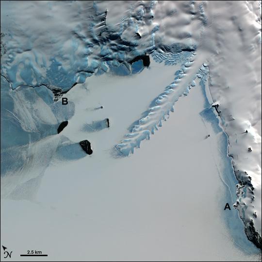
| Description | Map of the two possible mooring sites for the SY Aurora in 1915 in McMurdo Sound in Antarctica, superimposed on a much later image. The possible mooring sites for the ship were: the known mooring site at Hut Point (A) and the site they chose at Cape Evans (B). In this image, the Erebus ice tongue is shown extending from the Erebus glacier on Ross Island, Antarctica, into frozen McMurdo Sound. |
| Date | |
| Source | Based on Image:ErebusIceTongue ASTER 30nov2001.jpg, which is a modification by User:Howcheng of a U.S. government work in the public domain, further modified by User:Finetooth, with a bit removed by User:Ruhrfisch |
| Author | Ruhrfisch, Finetooth, Howcheng, and National Aeronautics and Space Administration (NASA) |
| Other versions | File:Mackintosh walk.png |
Licensing[edit]
I, the copyright holder of this work, hereby publish it under the following licenses:

|
Permission is granted to copy, distribute and/or modify this document under the terms of the GNU Free Documentation License, Version 1.2 or any later version published by the Free Software Foundation; with no Invariant Sections, no Front-Cover Texts, and no Back-Cover Texts. A copy of the license is included in the section entitled GNU Free Documentation License. |
This file is licensed under the Creative Commons Attribution-Share Alike 3.0 Unported license.
- You are free:
- to share – to copy, distribute and transmit the work
- to remix – to adapt the work
- Under the following conditions:
- attribution – You must give appropriate credit, provide a link to the license, and indicate if changes were made. You may do so in any reasonable manner, but not in any way that suggests the licensor endorses you or your use.
- share alike – If you remix, transform, or build upon the material, you must distribute your contributions under the same or compatible license as the original.
You may select the license of your choice.
| This file is in the public domain in the United States because it was solely created by NASA. NASA copyright policy states that "NASA material is not protected by copyright unless noted". (See Template:PD-USGov, NASA copyright policy page or JPL Image Use Policy.) | ||
 |
Warnings:
|
File history
Click on a date/time to view the file as it appeared at that time.
| Date/Time | Thumbnail | Dimensions | User | Comment | |
|---|---|---|---|---|---|
| current | 01:34, 7 April 2009 | | 540 × 540 (35 KB) | Ruhrfisch (talk | contribs) | == Summary == {{Information |Description= Map of the two possible mooring sites for the ''SY Aurora'' in 1915 in McMurdo Sound in Antarctica, superimposed on a much later image. The possible mooring sites for the ship were: the known mooring site at Hut P |
You cannot overwrite this file.
File usage on Commons
There are no pages that use this file.
File usage on other wikis
The following other wikis use this file:
- Usage on en.wikipedia.org
- Usage on es.wikipedia.org
- Usage on he.wikipedia.org
- Usage on ja.wikipedia.org
- Usage on my.wikipedia.org
- Usage on pt.wikipedia.org