File:Portland Streetcar map.svg
Jump to navigation
Jump to search

Size of this PNG preview of this SVG file: 525 × 600 pixels. Other resolutions: 210 × 240 pixels | 420 × 480 pixels | 672 × 768 pixels | 896 × 1,024 pixels | 1,792 × 2,048 pixels.
Original file (SVG file, nominally 525 × 600 pixels, file size: 7 KB)
Captions
Captions
Add a one-line explanation of what this file represents
Summary[edit]
| Description |
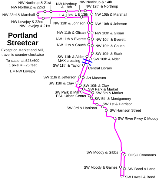
Geographically correct Portland Streetcar map with stop names Made using official TriMet data that's been made publicly available for Google Transit and others. Data was loaded into a spreadsheet and converted to SVG coordinates using the formulas: =((((Longitude-122)*256198)+62691308)/25)+125
and 583-((((Latitude-45)*364641)-180120)/25)
|
| Date | 8 June 2008 (original upload date) |
| Source | Own work |
| Author | Jason McHuff (talk) |
| Permission (Reusing this file) |
CC-BY-SA-3.0,2.5,2.0,1.0; Released under the GNU Free Documentation License. |
| Other versions | Also available on Flickr |
Licensing[edit]
Jmchuff at en.wikipedia, the copyright holder of this work, hereby publishes it under the following licenses:
This file is licensed under the Creative Commons Attribution-Share Alike 3.0 Unported, 2.5 Generic, 2.0 Generic and 1.0 Generic license.
Attribution: Jmchuff at en.wikipedia
- You are free:
- to share – to copy, distribute and transmit the work
- to remix – to adapt the work
- Under the following conditions:
- attribution – You must give appropriate credit, provide a link to the license, and indicate if changes were made. You may do so in any reasonable manner, but not in any way that suggests the licensor endorses you or your use.
- share alike – If you remix, transform, or build upon the material, you must distribute your contributions under the same or compatible license as the original.

|
Permission is granted to copy, distribute and/or modify this document under the terms of the GNU Free Documentation License, Version 1.2 or any later version published by the Free Software Foundation; with no Invariant Sections, no Front-Cover Texts, and no Back-Cover Texts. A copy of the license is included in the section entitled GNU Free Documentation License. |
You may select the license of your choice.
Original upload log[edit]
The original description page was here. All following user names refer to en.wikipedia.
| Date/Time | Dimensions | User | Comment |
|---|---|---|---|
| 2008-06-08 09:46 | 525×600× (6861 bytes) | Jmchuff | {{Information |Description=Geographically correct Portland Streetcar map with stop names Made using official TriMet data that's [http://developer.trimet.org/ been made publicly available] for [http://maps.google.com/help/maps/transit/ Google Transit] and |
File history
Click on a date/time to view the file as it appeared at that time.
| Date/Time | Thumbnail | Dimensions | User | Comment | |
|---|---|---|---|---|---|
| current | 06:23, 7 March 2016 | | 525 × 600 (7 KB) | Kingofthedead (talk | contribs) | Transferred from en.wikipedia |
You cannot overwrite this file.
File usage on Commons
The following 3 pages use this file:
File usage on other wikis
The following other wikis use this file:
- Usage on en.wikipedia.org