File:Porducción de olivas.PNG
Jump to navigation
Jump to search

Size of this preview: 800 × 460 pixels. Other resolutions: 320 × 184 pixels | 640 × 368 pixels | 1,024 × 588 pixels | 1,344 × 772 pixels.
Original file (1,344 × 772 pixels, file size: 63 KB, MIME type: image/png)
Captions
Captions
Add a one-line explanation of what this file represents
Summary[edit]
| Description |
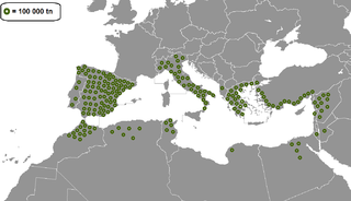
Afrikaans: Produksie van olywe per land in die Middellandse See-bekken. Elke sirkel simboliseer 100 000 tonelas van olyfproduksie.
Español: Producción de aceitunas por país en la cuenca del Mediterráneo. Cada círculo simboliza 100.000 tonelasds de producción de aceituna. |
| Date | |
| Source | Own work |
| Author | Fobos92 |

|
This map image could be re-created using vector graphics as an SVG file. This has several advantages; see Commons:Media for cleanup for more information. If an SVG form of this image is available, please upload it and afterwards replace this template with
{{vector version available|new image name}}.
It is recommended to name the SVG file “Porducción de olivas.svg”—then the template Vector version available (or Vva) does not need the new image name parameter. |
Licensing[edit]
I, the copyright holder of this work, hereby publish it under the following license:
This file is licensed under the Creative Commons Attribution-Share Alike 4.0 International license.
- You are free:
- to share – to copy, distribute and transmit the work
- to remix – to adapt the work
- Under the following conditions:
- attribution – You must give appropriate credit, provide a link to the license, and indicate if changes were made. You may do so in any reasonable manner, but not in any way that suggests the licensor endorses you or your use.
- share alike – If you remix, transform, or build upon the material, you must distribute your contributions under the same or compatible license as the original.
File history
Click on a date/time to view the file as it appeared at that time.
| Date/Time | Thumbnail | Dimensions | User | Comment | |
|---|---|---|---|---|---|
| current | 19:13, 10 October 2014 | | 1,344 × 772 (63 KB) | Maphobbyist (talk | contribs) | Rearranged the same number of dots for Turkey where they actually grow i.e with a Mediterranean climate. |
| 03:56, 18 September 2014 |  | 1,344 × 772 (52 KB) | Fobos92 (talk | contribs) | Libia, Jordania, Líbano, Israel y Albania | |
| 03:35, 18 September 2014 |  | 1,344 × 772 (52 KB) | Fobos92 (talk | contribs) | User created page with UploadWizard |
You cannot overwrite this file.
File usage on Commons
There are no pages that use this file.
File usage on other wikis
The following other wikis use this file:
- Usage on ast.wikipedia.org
- Usage on cs.wikipedia.org
- Usage on en.wikipedia.org
- Usage on es.wikipedia.org
- Usage on it.wikipedia.org
- Usage on tr.wikipedia.org