File:Popocatépetl's location and distance to major cities.jpg
Jump to navigation
Jump to search

Size of this preview: 800 × 450 pixels. Other resolutions: 320 × 180 pixels | 640 × 360 pixels | 1,215 × 684 pixels.
Original file (1,215 × 684 pixels, file size: 688 KB, MIME type: image/jpeg)
Captions
Captions
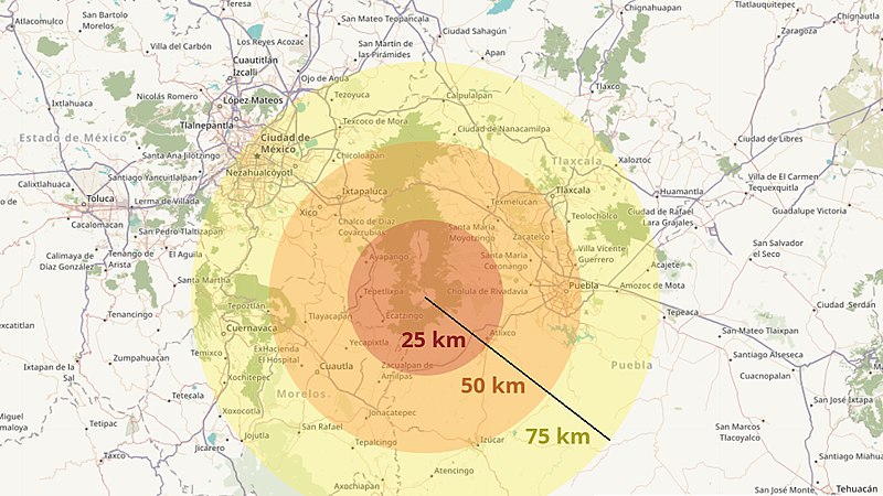
Distance from Popocatépetl to the surrounding cities
Summary[edit]
| Description |
Deutsch: Roter Radius: 25km, oranger Radius: 50km, gelber Radius: 75km
English: red radius: 25kms, orange radius: 50kms, yellow radius: 75kms |
| Date | |
| Source | Own work based on OpenStreetMap data (© OpenStreetMap contributors) |
| Author | Map: © OpenStreetMap contributors, overlay: own work |
Licensing[edit]
This file is licensed under the Creative Commons Attribution-Share Alike 2.5 Generic license.
- You are free:
- to share – to copy, distribute and transmit the work
- to remix – to adapt the work
- Under the following conditions:
- attribution – You must give appropriate credit, provide a link to the license, and indicate if changes were made. You may do so in any reasonable manner, but not in any way that suggests the licensor endorses you or your use.
- share alike – If you remix, transform, or build upon the material, you must distribute your contributions under the same or compatible license as the original.
File history
Click on a date/time to view the file as it appeared at that time.
| Date/Time | Thumbnail | Dimensions | User | Comment | |
|---|---|---|---|---|---|
| current | 08:09, 28 March 2019 | | 1,215 × 684 (688 KB) | Parangaricutirimícuaro (talk | contribs) | User created page with UploadWizard |
You cannot overwrite this file.
File usage on Commons
There are no pages that use this file.
File usage on other wikis
The following other wikis use this file:
- Usage on cs.wikipedia.org
- Usage on de.wikipedia.org