File:Pont-canal de l'Orb cf07.jpg
Jump to navigation
Jump to search

Size of this preview: 800 × 500 pixels. Other resolutions: 320 × 200 pixels | 640 × 400 pixels | 1,024 × 640 pixels | 1,280 × 800 pixels | 2,560 × 1,600 pixels | 7,300 × 4,563 pixels.
Original file (7,300 × 4,563 pixels, file size: 26.71 MB, MIME type: image/jpeg)
Captions
Captions
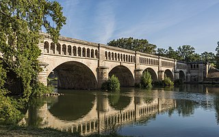
The bridge, Pont-canal de l'Orb in Béziers France
Summary[edit]
| Description |
English: Pont-canal de l'Orb. Béziers, Hérault, France
|
||
| Date | Taken on 11 September 2016, 10:40:14 | ||
| Source | Own work | ||
| Author | Christian Ferrer | ||
| Permission (Reusing this file) |
I, the copyright holder of this work, hereby publish it under the following license: This file is licensed under the Creative Commons Attribution-Share Alike 4.0 International license.
|
| Camera location | | View this and other nearby images on: OpenStreetMap |
|---|

|
This image was uploaded as part of Wiki Loves Monuments 2016.
|
Assessment[edit]
|
This image was selected as picture of the day on Wikimedia Commons for 28 September 2019. It was captioned as follows: Other languages:
|
File history
Click on a date/time to view the file as it appeared at that time.
| Date/Time | Thumbnail | Dimensions | User | Comment | |
|---|---|---|---|---|---|
| current | 19:18, 21 February 2017 | | 7,300 × 4,563 (26.71 MB) | Christian Ferrer (talk | contribs) | new |
| 12:16, 16 September 2016 |  | 7,300 × 4,563 (26.04 MB) | Christian Ferrer (talk | contribs) | User created page with UploadWizard |
You cannot overwrite this file.
File usage on Commons
The following 27 pages use this file:
- User talk:Christian Ferrer/Archive23
- User talk:Christian Ferrer/Archive24
- Commons:Featured picture candidates/File:Pont-canal de l'Orb cf07.jpg
- Commons:Featured picture candidates/Log/March 2017
- Commons:Featured pictures/Places/Architecture/Bridges
- Commons:Featured pictures/chronological/2017-A
- Commons:Picture of the Year/2017/Candidates
- Commons:Picture of the Year/2017/R1/Gallery/2017-A
- Commons:Picture of the Year/2017/R1/Gallery/ALL
- Commons:Picture of the Year/2017/R1/Gallery/Infrastructure
- Commons:Picture of the Year/2017/R1/Gallery/M03
- Commons:Picture of the Year/2017/R1/v/Pont-canal de l'Orb cf07.jpg
- Commons:Quality images/Subject/Architecture/Transport Infrastructure/Bridges/Archive 2017 to 2018
- Commons:Quality images candidates/Archives February 24 2017
- Template:Potd/2019-09
- Template:Potd/2019-09-28
- Template:Potd/2019-09-28 (cs)
- Template:Potd/2019-09-28 (en)
- Template:Potd/2019-09-28 (es)
- Template:Potd/2019-09-28 (hu)
- Template:Potd/2019-09-28 (it)
- Template:Potd/2019-09-28 (mk)
- Template:Potd/2019-09-28 (nl)
- Template:Potd/2019-09-28 (pl)
- Template:Potd/2019-09-28 (pt)
- Template:Potd/2019-09-28 (pt-br)
- Template:Potd/2019-09-28 (ru)
File usage on other wikis
The following other wikis use this file:
- Usage on crh.wikipedia.org
- Usage on cv.wikipedia.org
- Usage on de.wikipedia.org
- Usage on el.wikipedia.org
- Usage on en.wikipedia.org
- Usage on fr.wikipedia.org
- Usage on fr.wiktionary.org
- Usage on hu.wikipedia.org
- Usage on hy.wikipedia.org
- Usage on id.wikipedia.org
- Wikipedia:Gambar pilihan/2020
- Wikipedia:Gambar pilihan/Usulan/2020
- Wikipedia:Gambar pilihan/Usulan/2020/Periode 9
- Jembatan Orb
- Wikipedia:Gambar pilihan/35 2020
- Wikipedia:Arsip halaman utama/2020/05/16
- Wikipedia:Arsip halaman utama/2020/05/17
- Wikipedia:Arsip halaman utama/2020/05/18
- Wikipedia:Arsip halaman utama/2020/05/19
- Usage on ka.wikipedia.org
- Usage on kbp.wikipedia.org
- Usage on ko.wikipedia.org
- Usage on lbe.wikipedia.org
- Usage on lez.wikipedia.org
- Usage on mk.wikipedia.org
- Usage on os.wikipedia.org
- Usage on pt.wikipedia.org
- Usage on ru.wikipedia.org
- Usage on ru.wikinews.org
- Usage on sah.wikipedia.org
- Usage on sl.wikipedia.org
- Usage on tt.wikipedia.org
- Usage on uk.wikipedia.org
- Usage on vep.wikipedia.org
- Usage on zh.wikipedia.org