File:Polysticta stelleri range map.png
Jump to navigation
Jump to search
No higher resolution available.
Polysticta_stelleri_range_map.png (600 × 600 pixels, file size: 32 KB, MIME type: image/png)
Captions
Captions
Add a one-line explanation of what this file represents
Summary[edit]
| Description |
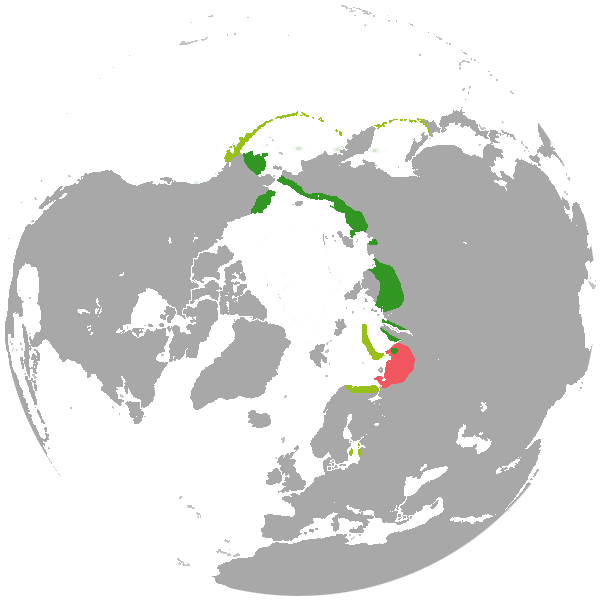
English: Polysticta stelleri range map. Sourse - http://maps.iucnredlist.org/map.html?id=100600487
Български: Ареал на разпространение на стелеровата гага. В тъмно зелено - ареар на гнездене; в светлозелено - ареал на зимуване; в червено - бивш ареал на разпространение. |
| Source | Own work |
| Author | Izvora |
Licensing[edit]
| I, the copyright holder of this work, release this work into the public domain. This applies worldwide. In some countries this may not be legally possible; if so: I grant anyone the right to use this work for any purpose, without any conditions, unless such conditions are required by law. |
File history
Click on a date/time to view the file as it appeared at that time.
| Date/Time | Thumbnail | Dimensions | User | Comment | |
|---|---|---|---|---|---|
| current | 20:31, 6 August 2012 | | 600 × 600 (32 KB) | Izvora (talk | contribs) | {{Information |Description ={{en|1=Polysticta stelleri range map. Sourse - http://maps.iucnredlist.org/map.html?id=100600487}} {{bg|1=Ареал на разпространение на стелеровата гага. В тъмно зелено - ... |
You cannot overwrite this file.
File usage on Commons
There are no pages that use this file.
File usage on other wikis
The following other wikis use this file:
- Usage on ceb.wikipedia.org
- Usage on en.wikipedia.org
- Usage on eo.wikipedia.org
- Usage on es.wikipedia.org
- Usage on fi.wikipedia.org
- Usage on fr.wikipedia.org
- Usage on gl.wikipedia.org
- Usage on he.wikipedia.org
- Usage on is.wikipedia.org
- Usage on nl.wikipedia.org
- Usage on nn.wikipedia.org
- Usage on pt.wikipedia.org
- Usage on sv.wikipedia.org
- Usage on uk.wikipedia.org
- Usage on vi.wikipedia.org