File:Polska okupacja 1944.png
Jump to navigation
Jump to search

Size of this preview: 451 × 600 pixels. Other resolutions: 180 × 240 pixels | 361 × 480 pixels | 577 × 768 pixels | 770 × 1,024 pixels | 2,043 × 2,717 pixels.
Original file (2,043 × 2,717 pixels, file size: 2.61 MB, MIME type: image/png)
Captions
Captions
Add a one-line explanation of what this file represents
Summary[edit]
| Description |
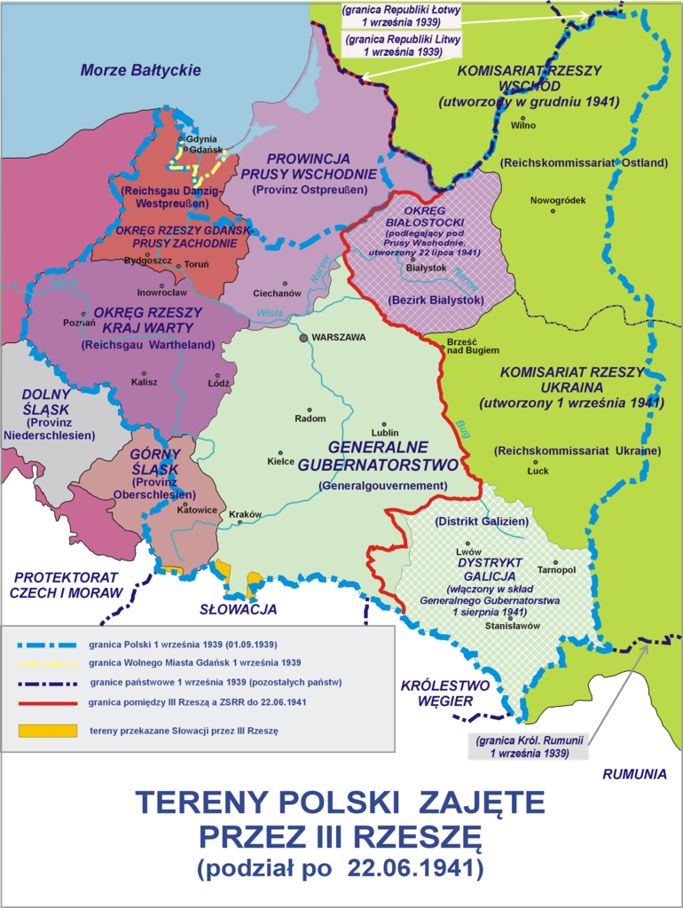
Polski: Tereny Polski zajęte przez III Rzeszę - podział po 22.06.1941
English: Poland occupied by Nazi Germany - after 22.06.1941 |
| Date | |
| Source |
Own work. Composite map derived from a variety of readily available sources which may or may not include: |
| Author | Lonio17 |
| Other versions |
[]
|


Licensing[edit]
I, the copyright holder of this work, hereby publish it under the following licenses:

|
Permission is granted to copy, distribute and/or modify this document under the terms of the GNU Free Documentation License, Version 1.2 or any later version published by the Free Software Foundation; with no Invariant Sections, no Front-Cover Texts, and no Back-Cover Texts. A copy of the license is included in the section entitled GNU Free Documentation License. |
This file is licensed under the Creative Commons Attribution-Share Alike 4.0 International, 3.0 Unported, 2.5 Generic, 2.0 Generic and 1.0 Generic license.
- You are free:
- to share – to copy, distribute and transmit the work
- to remix – to adapt the work
- Under the following conditions:
- attribution – You must give appropriate credit, provide a link to the license, and indicate if changes were made. You may do so in any reasonable manner, but not in any way that suggests the licensor endorses you or your use.
- share alike – If you remix, transform, or build upon the material, you must distribute your contributions under the same or compatible license as the original.
You may select the license of your choice.
File history
Click on a date/time to view the file as it appeared at that time.
| Date/Time | Thumbnail | Dimensions | User | Comment | |
|---|---|---|---|---|---|
| current | 12:11, 8 October 2021 | | 2,043 × 2,717 (2.61 MB) | Kamilhrub (talk | contribs) | Korekta kształtu dystryktu lubelskiego, w 1941 nie był zmniejszony, lecz zachowano w nim pas północnej Galicji (na podstawie wykazu gmin GG w 1943). |
| 07:08, 19 October 2009 |  | 2,043 × 2,717 (2.13 MB) | Lonio17 (talk | contribs) | {{Information |Description={{pl|1=Tereny Polski zajęte przez III Rzeszę - podział po 22.06.1941}} |Source={{own}} |Author=Lonio17 |Date=2009-10-19 |Permission= |other_versions= }} Category:Maps of Poland during World War II [[Cat | |
| 09:31, 24 September 2009 |  | 1,954 × 2,598 (2.01 MB) | Lonio17 (talk | contribs) | {{Information |Description={{pl|1=Tereny Polski zajęte przez III Rzeszę - podział po 22.06.1941}} |Source={{own}} |Author=Lonio17 |Date=2009-00-24 |Permission= |other_versions= }} Category:Maps of Poland during World War II [[Cat | |
| 14:09, 30 May 2009 |  | 1,954 × 2,598 (2.01 MB) | Lonio17 (talk | contribs) | {{Information |Description={{pl|1=Tereny Polski zajęte przez III Rzeszę - podział po 22.06.1941}} |Source=Praca własna osoby przesyłającej (own work by uploader) |Author=Lonio17 |Date=2009-05=30 |Permission= |other_versions= }} <!- | |
| 12:54, 30 May 2009 |  | 1,954 × 2,598 (2.01 MB) | Lonio17 (talk | contribs) | {{Information |Description={{pl|1=Tereny Polski zajęte przez III Rzeszę - podział po 22.06.1941}} |Source=Praca własna osoby przesyłającej (own work by uploader) |Author=Lonio17 |Date=2009-05-30 |Permission= |other_versions= }} <!- | |
| 07:51, 30 April 2009 |  | 1,954 × 2,598 (2.02 MB) | Lonio17 (talk | contribs) | {{Information |Description=Tereny Polski zajęte przez III Rzeszę - podział po 22.06.1941 |Source=Praca własna osoby przesyłającej (own work by uploader) |Date=2009-04-30 |Author=Lonio17 |Permission={{GFDL-self}} {{Cc-by-sa-3.0,2.5,2 | |
| 10:52, 29 April 2009 |  | 1,954 × 2,590 (2.04 MB) | Lonio17 (talk | contribs) | {{Information |Description=Tereny Polski zajęte przez III Rzeszę - podział po 22.06.1941 |Source=Praca własna osoby przesyłającej (own work by uploader) |Date=2009-04-29 |Author=Lonio17 |Permission={{GFDL-self}} {{Cc-by-sa-3.0,2.5,2 | |
| 06:00, 29 April 2009 |  | 1,954 × 2,590 (2.04 MB) | Lonio17 (talk | contribs) | {{Information |Description=Tereny Polski zajęte przez III Rzeszę - podział po 22.06.1941 |Source=Praca własna osoby przesyłającej (own work by uploader) |Date=2009-04-29 |Author=Lonio17 |Permission={{GFDL-self}} {{Cc-by-sa-3.0,2.5,2 | |
| 19:59, 27 April 2009 |  | 2,011 × 2,511 (1.85 MB) | Lonio17 (talk | contribs) | {{Information |Description=Tereny Polski zajęte przez III Rzeszę - podział po 22.06.1941 |Source=Praca własna osoby przesyłającej (own work by uploadrer) |Date=2009-04-27 |Author=Lonio17 |Permission={{GFDL-self}} {{Cc-by-sa-3.0,2.5, | |
| 17:37, 27 April 2009 |  | 2,011 × 2,511 (1.87 MB) | Lonio17 (talk | contribs) | {{Information |Description=Tereny Polski zajete przez III Rzeszę - podział po 22.06.1941 |Source=Praca własna osoby przesyłajacej (own work by uploader) |Date=2009-04-27 |Author=Lonio17 |Permission={{GFDL-self}} {{Cc-by-sa-3.0,2.5,2.0 |
You cannot overwrite this file.
File usage on Commons
The following 6 pages use this file:
File usage on other wikis
The following other wikis use this file:
- Usage on ca.wikipedia.org
- Usage on et.wikipedia.org
- Usage on fr.wikipedia.org
- Usage on pl.wikipedia.org
- II Rzeczpospolita
- Wikipedysta:Raz1el/brudnopis 2
- Okupacja niemiecka ziem polskich (1939–1945)
- Podział administracyjny terenów II Rzeczypospolitej podczas II wojny światowej
- Wikipedysta:Lonio17
- Historia Polski (1939–1945)
- Dyskusja wikipedysty:Lonio17
- Wikipedysta:Rynio55/brudnopis/Garnizon Przasnysz/2
- Wikipedysta:Zmechowiec 75/brudnopis/Garnizon Przasnysz