File:Political map of the Caucasus and its surroundings between 1795–1801.svg
Jump to navigation
Jump to search

Size of this PNG preview of this SVG file: 800 × 440 pixels. Other resolutions: 320 × 176 pixels | 640 × 352 pixels | 1,024 × 563 pixels | 1,280 × 704 pixels | 2,560 × 1,408 pixels | 4,973 × 2,735 pixels.
Original file (SVG file, nominally 4,973 × 2,735 pixels, file size: 8.94 MB)
Captions
Captions
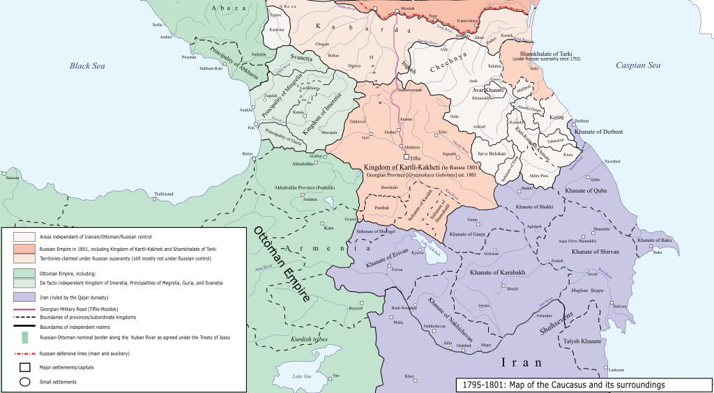
Political map of the Caucasus and its surroundings between 1795–1801
Summary[edit]
| Description |
English: Political map of the Caucasus and its surroundings between 1795–1801 |
| Date | |
| Source |
Own work This map is based on two sources, both which have various maps that depict the political status of the Caucasus during this era. I tried to mainly base it on the maps and information provided by Bournoutian, as he has better credentials.
|
| Author | HistoryofIran |
Licensing[edit]
I, the copyright holder of this work, hereby publish it under the following license:
This file is licensed under the Creative Commons Attribution-Share Alike 4.0 International license.
- You are free:
- to share – to copy, distribute and transmit the work
- to remix – to adapt the work
- Under the following conditions:
- attribution – You must give appropriate credit, provide a link to the license, and indicate if changes were made. You may do so in any reasonable manner, but not in any way that suggests the licensor endorses you or your use.
- share alike – If you remix, transform, or build upon the material, you must distribute your contributions under the same or compatible license as the original.
File history
Click on a date/time to view the file as it appeared at that time.
| Date/Time | Thumbnail | Dimensions | User | Comment | |
|---|---|---|---|---|---|
| current | 01:03, 1 June 2022 | | 4,973 × 2,735 (8.94 MB) | HistoryofIran (talk | contribs) | Uploaded own work with UploadWizard |
You cannot overwrite this file.
File usage on Commons
The following page uses this file:
File usage on other wikis
The following other wikis use this file:
- Usage on en.wikipedia.org
Metadata
Categories:
- SVG maps of the history of Azerbaijan
- Maps of the history of Armenia
- Maps of the history of Georgia
- Maps of the history of the south Caucasus region
- Maps of the history of the Caucasus
- Maps of Khanates of the South Caucasus
- George Bournoutian
- Maps of the history of Iran
- History of Derbent
- English-language SVG maps showing history
- Maps of the history of Dagestan
- Maps showing 18th-century history
- Maps showing 19th-century history
- Maps of Qajar Iran
- Maps of the Ottoman Empire
- Maps of the Russian Empire
- Kartli-Kakheti