File:Polen - historische Regionen.png
Jump to navigation
Jump to search
Size of this preview: 561 × 599 pixels. Other resolutions: 225 × 240 pixels | 449 × 480 pixels | 719 × 768 pixels | 958 × 1,024 pixels | 2,430 × 2,596 pixels.
Original file (2,430 × 2,596 pixels, file size: 891 KB, MIME type: image/png)
Captions
Captions
Add a one-line explanation of what this file represents
Summary[edit]
| Description |
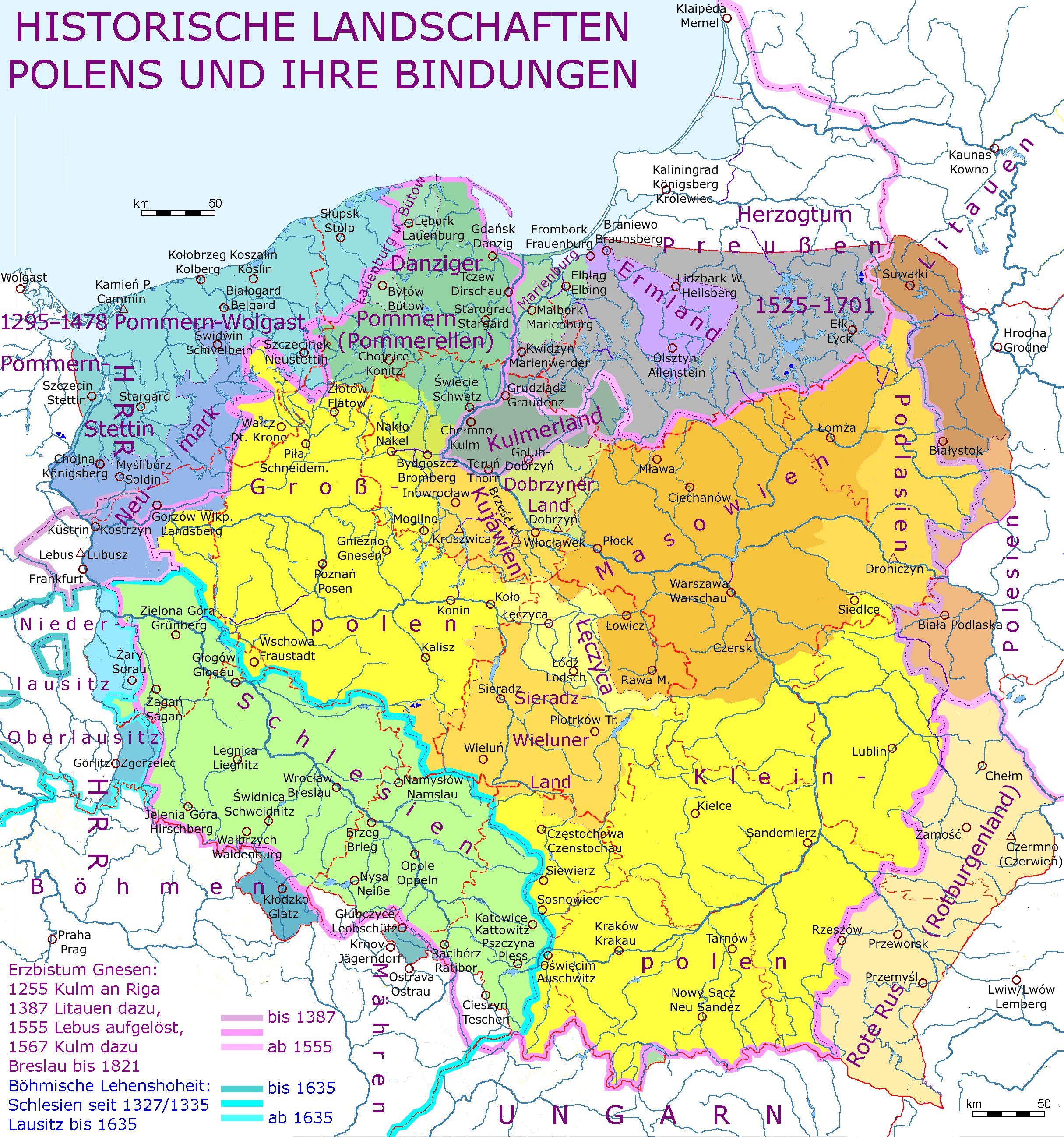
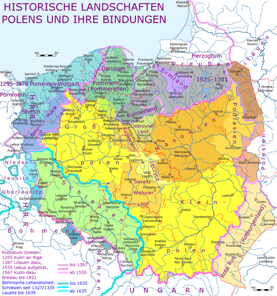
Deutsch: Historische Regionen Polens und ihre Bindungen; unterlegt mit Gewässernetz |
| Date | |
| Source | File:RegionyHistPolski.png, File:Kujawsko-pomorskie_mapa_fizyczna.png, File:Lubelskie_mapa_fizyczna.png, File:Malopolskie_mapa_fizyczna.png, File:Mazowieckie_mapa_fizyczna.png, File:Opolskie_mapa_fizyczna.png, File:Podkarpackie mapa fizyczna.png, File:Pomorskie_mapa_fizyczna.png, File:Slaskie mapa fizyczna.png, File:Swietokrzyskie_mapa_administracyjna.png, File:Warminsko mazurskie mapa fizyczn.png, File:Wielkopolskie mapa fizyczna.png, File:Zachodniopomorskie mapa fizyczna.png, File:1SK-KR-GFM.png, Openstreetmap, https://maps-for-free.com/ , informations from Andrees Handatlas (1880) and newer maps, informations from (editor: Erwin Gatz) Atlas zur Kirche in Geschichte und Gegenwart (2009, ISBN 978-3-7954-2181-6) |
| Author | Ulamm (talk) |
| Other versions | see source number one |
Licensing[edit]
I, the copyright holder of this work, hereby publish it under the following licenses:

|
Permission is granted to copy, distribute and/or modify this document under the terms of the GNU Free Documentation License, Version 1.2 or any later version published by the Free Software Foundation; with no Invariant Sections, no Front-Cover Texts, and no Back-Cover Texts. A copy of the license is included in the section entitled GNU Free Documentation License. |
This file is licensed under the Creative Commons Attribution-Share Alike Attribution-Share Alike 4.0 International, 3.0 Unported, 2.5 Generic, 2.0 Generic and 1.0 Generic license.
- You are free:
- to share – to copy, distribute and transmit the work
- to remix – to adapt the work
- Under the following conditions:
- attribution – You must give appropriate credit, provide a link to the license, and indicate if changes were made. You may do so in any reasonable manner, but not in any way that suggests the licensor endorses you or your use.
- share alike – If you remix, transform, or build upon the material, you must distribute your contributions under the same or compatible license as the original.
You may select the license of your choice.
File history
Click on a date/time to view the file as it appeared at that time.
| Date/Time | Thumbnail | Dimensions | User | Comment | |
|---|---|---|---|---|---|
| current | 14:10, 13 August 2019 | | 2,430 × 2,596 (891 KB) | Ulamm (talk | contribs) | + scale rulers |
| 09:57, 17 July 2018 |  | 2,430 × 2,596 (890 KB) | Ulamm (talk | contribs) | re-insertion of the label "Podlasien" | |
| 09:53, 17 July 2018 |  | 2,430 × 2,596 (889 KB) | Ulamm (talk | contribs) | two spellings an one localization corrected | |
| 08:36, 16 July 2018 |  | 2,430 × 2,596 (890 KB) | Ulamm (talk | contribs) | Szczecinek | |
| 21:59, 3 July 2018 |  | 2,430 × 2,596 (891 KB) | Ulamm (talk | contribs) | {{Information |Description={{de|Historische Regionen Polens und ihre Bindungen; unterlegt mit Gewässernetz}} |Source=File:RegionyHistPolski.png, File:Kujawsko-pomorskie_mapa_fizyczna ro.png, File:Lubelskie_mapa_fizyczna ro.png, File:Malopolskie_mapa_fizyczna.png, File:Mazowieckie_mapa_fizyczna.png, File:Opolskie_mapa_fizyczna.png, File:Podkarpackie mapa fizyczna.png, File:Pomorskie_mapa_fizyczna.png, File:Slaskie mapa fizyczna klar.png, [[:File:Swi... |
You cannot overwrite this file.
File usage on Commons
There are no pages that use this file.
File usage on other wikis
The following other wikis use this file:
- Usage on de.wikipedia.org
- Geschichte Polens
- Kleinpolnisch
- Erzbistum Gniezno
- Liste der Backsteinbauwerke der Gotik in Polen
- Diskussion:Liste der Bauwerke der norddeutschen und rheinischen Backsteingotik in Deutschland
- Benutzer:Ulamm/Backsteinbauwerke der Gotik in Polen und der Ukraine
- Liste der Hallenkirchen in Polen
- Liste der Pseudobasiliken in Polen
- Usage on en.wikipedia.org
- Usage on fr.wikipedia.org