File:Point Defiance Bypass.svg
Jump to navigation
Jump to search

Size of this PNG preview of this SVG file: 481 × 600 pixels. Other resolutions: 192 × 240 pixels | 385 × 480 pixels | 616 × 768 pixels | 821 × 1,024 pixels | 1,642 × 2,048 pixels | 1,132 × 1,412 pixels.
Original file (SVG file, nominally 1,132 × 1,412 pixels, file size: 2.14 MB)
Captions
Captions
Add a one-line explanation of what this file represents
Summary[edit]
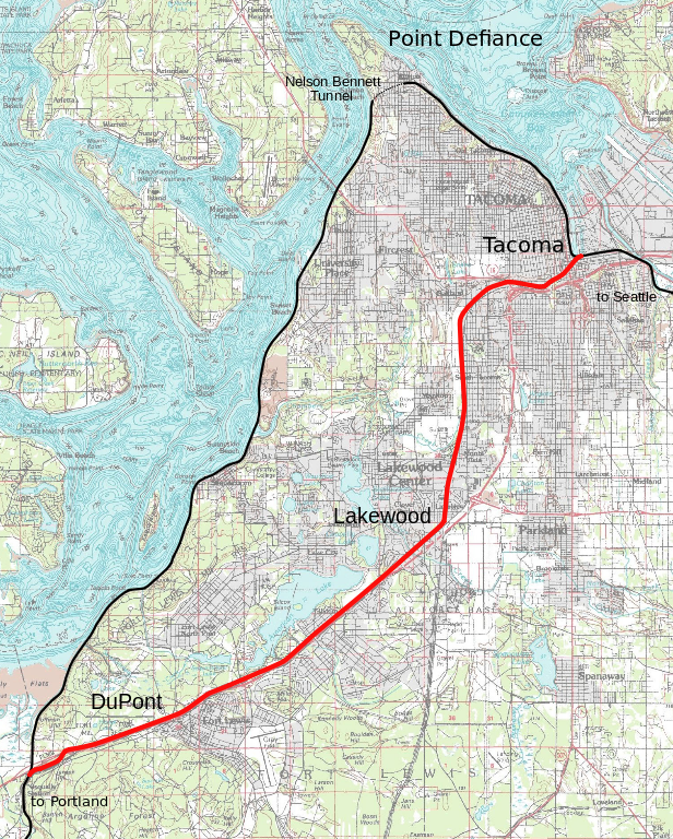
| Description | Amtrak's Port Defiance Bypass plans |
| Date | |
| Source | Own work on USGS topo map |
| Author | User:SPUI |
| This work has been released into the public domain by its author, SPUI. This applies worldwide. In some countries this may not be legally possible; if so: |
This image is in the public domain in the United States because it only contains materials that originally came from the United States Geological Survey, an agency of the United States Department of the Interior. For more information, see the official USGS copyright policy.
|
File history
Click on a date/time to view the file as it appeared at that time.
| Date/Time | Thumbnail | Dimensions | User | Comment | |
|---|---|---|---|---|---|
| current | 23:11, 21 September 2005 | | 1,132 × 1,412 (2.14 MB) | SPUI~commonswiki (talk | contribs) | {{spuimap}} {{PD-USGS}} Point Defiance Bypass plans traced on a USGS topo. category:Amtrak category:Tacoma, Washington category:railroad maps |
You cannot overwrite this file.
File usage on Commons
The following 2 pages use this file:
File usage on other wikis
The following other wikis use this file:
- Usage on en.wikipedia.org
- Usage on fr.wikipedia.org
- Usage on www.wikidata.org