File:Pohjoismaat ja Baltia - kartta.svg

Original file (SVG file, nominally 934 × 690 pixels, file size: 2.56 MB)
Captions
Captions
Summary[edit]
| Description |
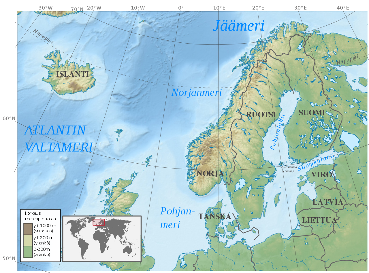
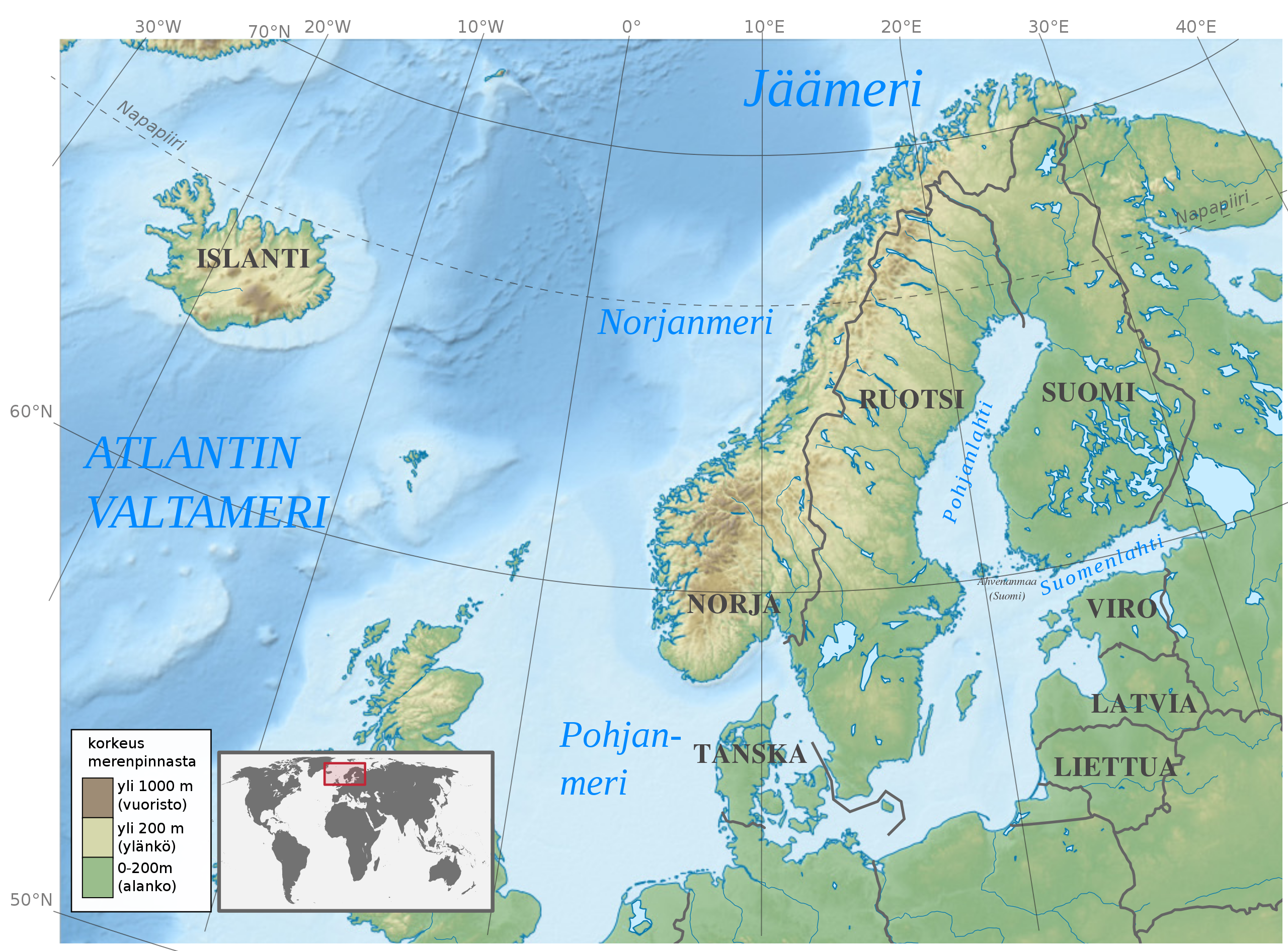
Suomi: Peruskartta Pohjoismaista ja Baltian maista sekä niitä ympäröivistä merialueista. |
| Date | |
| Source |
I created this image by using the image made by TUBS - Oma teosTämä vektorigrafiikkatiedosto luotiin käyttäen apuna ohjelmaa Adobe Illustrator. Tämä tiedosto tallennettiin Commonsiin Commonist-tietokoneohjelmalla. This vector image includes elements that have been taken or adapted from this: Europe laea location map.svg (by Alexrk2).This vector image includes elements that have been taken or adapted from this: WorldMap.svg (by CodeOne).This vector image includes elements that have been taken or adapted from this: Azerbaijan location map.svg (by Uwe Dedering).This vector image includes elements that have been taken or adapted from this: Moldova location map.svg (by NordNordWest).This vector image includes elements that have been taken or adapted from this: Georgia location map.svg (by NordNordWest).This vector image includes elements that have been taken or adapted from this: Europe relief laea location map.jpg (by Alexrk2).(Alexrk2 has sent me elements of the latter file seperately via e-mail), CC BY-SA 3.0, https://commons.wikimedia.org/w/index.php?curid=14676716 I added the coordinates grid and the finnish names. I made the coordinates grid by using Europe relief laea location map.jpg: Alexrk2derivative work: Pethrus - Europe relief laea location map.jpg, CC BY-SA 3.0, https://commons.wikimedia.org/w/index.php?curid=9949555 The Finnish names as well as the legend is made by me. |
| Author |
Europe relief laea location map.jpg: Alexrk2derivative work: Pethrus - Europe relief laea location map.jpg, CC BY-SA 3.0, https://commons.wikimedia.org/w/index.php?curid=9949555 TUBS - Oma teosTämä vektorigrafiikkatiedosto luotiin käyttäen apuna ohjelmaa Adobe Illustrator. Tämä tiedosto tallennettiin Commonsiin Commonist-tietokoneohjelmalla. This vector image includes elements that have been taken or adapted from this: Europe laea location map.svg (by Alexrk2).This vector image includes elements that have been taken or adapted from this: WorldMap.svg (by CodeOne).This vector image includes elements that have been taken or adapted from this: Azerbaijan location map.svg (by Uwe Dedering).This vector image includes elements that have been taken or adapted from this: Moldova location map.svg (by NordNordWest).This vector image includes elements that have been taken or adapted from this: Georgia location map.svg (by NordNordWest).This vector image includes elements that have been taken or adapted from this: Europe relief laea location map.jpg (by Alexrk2).(Alexrk2 has sent me elements of the latter file seperately via e-mail), CC BY-SA 3.0, https://commons.wikimedia.org/w/index.php?curid=14676716 Opetustuubi |
Licensing[edit]
- You are free:
- to share – to copy, distribute and transmit the work
- to remix – to adapt the work
- Under the following conditions:
- attribution – You must give appropriate credit, provide a link to the license, and indicate if changes were made. You may do so in any reasonable manner, but not in any way that suggests the licensor endorses you or your use.
- share alike – If you remix, transform, or build upon the material, you must distribute your contributions under the same or compatible license as the original.
File history
Click on a date/time to view the file as it appeared at that time.
| Date/Time | Thumbnail | Dimensions | User | Comment | |
|---|---|---|---|---|---|
| current | 14:05, 16 December 2018 | | 934 × 690 (2.56 MB) | Opetustuubi (talk | contribs) | User created page with UploadWizard |
You cannot overwrite this file.
File usage on Commons
There are no pages that use this file.