File:Plan of the Town and Harbour of St. Augustine, 1762.jpg
Jump to navigation
Jump to search
No higher resolution available.
Plan_of_the_Town_and_Harbour_of_St._Augustine,_1762.jpg (700 × 497 pixels, file size: 118 KB, MIME type: image/jpeg)
Captions
Captions
Add a one-line explanation of what this file represents
Summary[edit]
| Description |
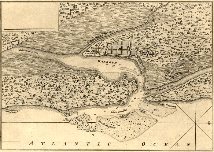
English: Map of St. Augustine, Florida, and its harbor, drawn by Thomas Jefferys, circa 1762. Insert between pp. 24-25 from "An Account of the First Discovery and Natural History of Florida", 1763, by William Roberts. Shows roads, water depths by soundings, locations, physical features and inland waters. The scale for the map is 1:47,000. |
| Date | |
| Source | Geography and Map Division of the Library of Congress |
| Author | William Roberts |
Licensing[edit]
|
This work is in the public domain in its country of origin and other countries and areas where the copyright term is the author's life plus 100 years or fewer. | |
| This file has been identified as being free of known restrictions under copyright law, including all related and neighboring rights. | |
File history
Click on a date/time to view the file as it appeared at that time.
| Date/Time | Thumbnail | Dimensions | User | Comment | |
|---|---|---|---|---|---|
| current | 22:32, 7 September 2013 | | 700 × 497 (118 KB) | Carlstak (talk | contribs) | User created page with UploadWizard |
You cannot overwrite this file.
File usage on Commons
There are no pages that use this file.
File usage on other wikis
The following other wikis use this file:
- Usage on en.wikipedia.org