File:Plan of railroads north and east of Boston, with the projected railroads from Danvers, Georgetown & Gloucester; showing the situation of the towns & villages, their distance from Boston & number of LOC 98688494.jpg
Jump to navigation
Jump to search

Size of this preview: 710 × 600 pixels. Other resolutions: 284 × 240 pixels | 568 × 480 pixels | 909 × 768 pixels | 1,212 × 1,024 pixels | 2,425 × 2,048 pixels | 6,384 × 5,392 pixels.
Original file (6,384 × 5,392 pixels, file size: 4.05 MB, MIME type: image/jpeg)
Captions
Captions
Add a one-line explanation of what this file represents
Summary[edit]
| Description |
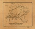
English: Outline map, oriented to the west, of the area north of Boston showing the rail network. |
||
| Title | Plan of railroads north and east of Boston, with the projected railroads from Danvers, Georgetown & Gloucester; showing the situation of the towns & villages, their distance from Boston & number of inhabitants. | ||
| Shelf ID | G3761.P3 1850 .L4 | ||
| Date | |||
| Source | https://www.loc.gov/item/98688494/ | ||
| Author | Lewis, Alonzo | ||
| Permission (Reusing this file) |
|
||
| Other versions |
|
||
| Location | United States · Massachusetts | ||
| Part of | American Memory · Catalog · Railroad Maps, 1828-1900 · Geography And Map Division · Transportation And Communication | ||
| Subject | United States · Maps · Railroads · Massachusetts |

Licensing[edit]
|
This is a faithful photographic reproduction of a two-dimensional, public domain work of art. The work of art itself is in the public domain for the following reason:
The official position taken by the Wikimedia Foundation is that "faithful reproductions of two-dimensional public domain works of art are public domain".
This photographic reproduction is therefore also considered to be in the public domain in the United States. In other jurisdictions, re-use of this content may be restricted; see Reuse of PD-Art photographs for details. | ||||
File history
Click on a date/time to view the file as it appeared at that time.
| Date/Time | Thumbnail | Dimensions | User | Comment | |
|---|---|---|---|---|---|
| current | 16:16, 9 June 2018 | | 6,384 × 5,392 (4.05 MB) | Fæ (talk | contribs) | LOC Maps https://www.loc.gov/item/98688494/ #24902 |
You cannot overwrite this file.
File usage on Commons
The following page uses this file: