File:Plan of basin between 12 & 10th streets as laid out for the Canal Co. - (Washington Canal, Washington D.C.). LOC 88690731.jpg
Jump to navigation
Jump to search

Size of this preview: 754 × 600 pixels. Other resolutions: 302 × 240 pixels | 604 × 480 pixels | 966 × 768 pixels | 1,280 × 1,018 pixels | 2,560 × 2,036 pixels | 2,843 × 2,261 pixels.
Original file (2,843 × 2,261 pixels, file size: 711 KB, MIME type: image/jpeg)
Captions
Captions
Add a one-line explanation of what this file represents
Summary[edit]
| Description |
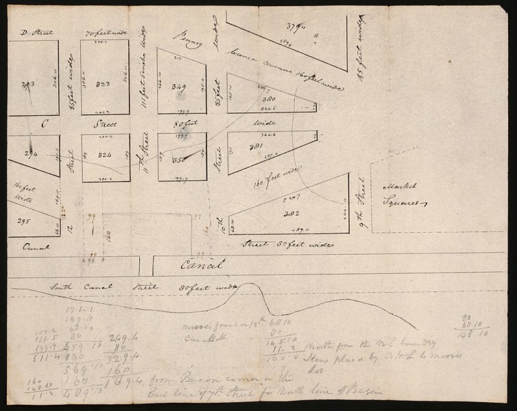
English: Also covers part of central business district adjacent to canal. Ink and lead pencil. Mounted on cloth backing. Includes notes and computations. Title in ink on verso. Available also through the Library of Congress Web site as a raster image. Phillips. Washington 72 Vault DCP |
||
| Title | Plan of basin between 12 & 10th streets as laid out for the Canal Co. : [Washington Canal, Washington D.C.]. | ||
| Shelf ID | G3852.W28 181- .P5 | ||
| Date | |||
| Source | https://www.loc.gov/item/88690731/ | ||
| Author | Unknown author | ||
| Permission (Reusing this file) |
|
||
| Other versions |
|
||
| Location | Washington D.C. · United States · Washington Canal · Washington · Washington. · Washington · United States · District Of Columbia · District Of Columbia | ||
| Part of | American Memory · Cities And Towns · Catalog · Geography And Map Division | ||
| Subject | Maps, Manuscript · Washington (D.C.) · Washington · Washington Canal · Central Business Districts · United States · Maps · Washington Canal (Washington, D.C.) · District Of Columbia · Manuscript Maps |


._LOC_88690731.jpg&action=edit§ion=1)
Licensing[edit]
._LOC_88690731.jpg&action=edit§ion=2)
|
This is a faithful photographic reproduction of a two-dimensional, public domain work of art. The work of art itself is in the public domain for the following reason:
The official position taken by the Wikimedia Foundation is that "faithful reproductions of two-dimensional public domain works of art are public domain".
This photographic reproduction is therefore also considered to be in the public domain in the United States. In other jurisdictions, re-use of this content may be restricted; see Reuse of PD-Art photographs for details. | ||||
File history
Click on a date/time to view the file as it appeared at that time.
| Date/Time | Thumbnail | Dimensions | User | Comment | |
|---|---|---|---|---|---|
| current | 20:27, 15 May 2018 | | 2,843 × 2,261 (711 KB) | Fæ (talk | contribs) | LOC Maps https://www.loc.gov/item/88690731/ #9159 |
You cannot overwrite this file.
File usage on Commons
The following page uses this file:
._LOC_88690731.jpg&oldid=842003717)