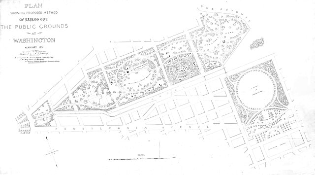
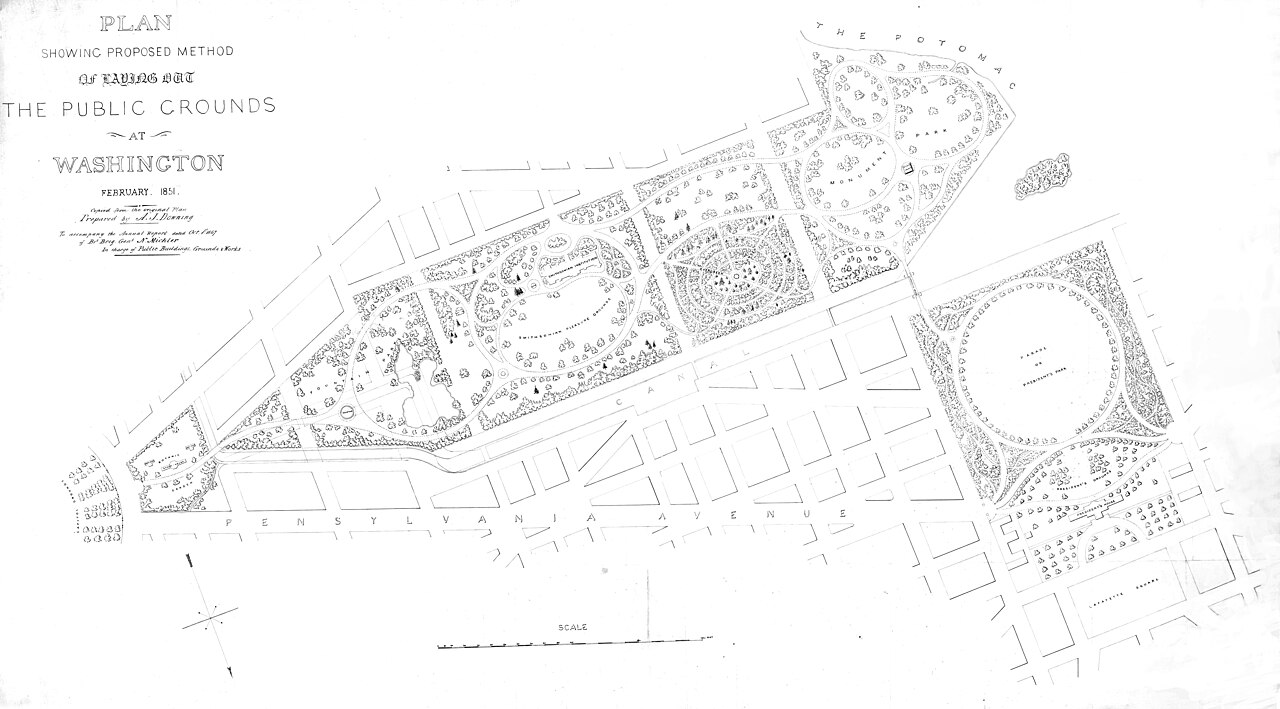
File:Plan Showing Proposed Method, The Public Grounds at Washington, February 1851. A.J. Downing (847cc92a-693f-46d9-9865-6707a0089d82).jpg

Original file (4,500 × 2,493 pixels, file size: 2.24 MB, MIME type: image/jpeg)
Captions
Captions

|
The categories of this image need checking. You can do so here.
|
.jpg&action=edit&withJS=MediaWiki:Catcheck.js)
Summary[edit]
.jpg&action=edit§ion=1)
| English: Plan Showing Proposed Method, The Public Grounds at Washington, February 1851. A.J. Downing | |||
|---|---|---|---|
| Photographer |
English: National Archives / A.J. Downing |
||
| Title |
English: Plan Showing Proposed Method, The Public Grounds at Washington, February 1851. A.J. Downing |
||
| Publisher |
English: U.S. Department of the Interior, National Park Service |
||
| Description |
English: Historic map in grayscale illustrating Downing’s plan for the National Mall, which shows a series of paths through wooded areas, gardens, monuments and memorials, public buildings, like the U.S. President’s residence. Primary text on map reads “Plan Showing Proposed Method, The Public Grounds at Washington, February 1851." The text on the map is as follows: PLAN SHOWING PROPROSED METHOD OF LAYING OUT THE PUBLIC GROUNDS AT WASHINGTON FEBRUARY 1851 copied from the original plan Prepared by A.J. Downing To accompany the Annual Report dated Oct. 1st, 1867 of Bvt Birg Genl N. Michler In charge of Public Buildings, Grounds & Works Other Identifier Andrew Jackson (A.J.) Downing's February 1851 map, "Plan Showing Proposed Method, The Public Grounds at Washington." This copy of the well-known map has been altered for clarity (see Comments for details). The original version was downloaded from the National Archives: https://catalog.archives.gov/id/6087997. The original version was downloaded from the National Archives in two files: one of the left side and the other of the right side. The two sections were merged. Damage and other artifacts were fixed. Image was converted to grayscale and contrast and levels adjusted for clarity. |
||
| Depicted place |
English: National Mall, District of Columbia , District of Columbia; Thomas Jefferson Memorial, District of Columbia , District of Columbia; Washington Monument, District of Columbia , District of Columbia; Lincoln Memorial, District of Columbia , District of Columbia |
||
| Date | Taken on 1 February 1851 | ||
| Accession number | |||
| References | https://catalog.archives.gov/id/6087997 | ||
| Source |
English: NPGallery |
||
| Permission (Reusing this file) |
|
||
| Contacts | English: Person: Cynthia Wanschura Organization: National Capital Regional Office, National Park Service Role: NPGallery Asset Creator Position: Regional GIS Specialist |
||
| NPS Unit Code | NACC, MALL, JEFM, WAMO, LINC | ||
| Cartographer | English: Andrew Jackson (A.J.) Downing |
||
| Album(s) | English: NCR UERLA Valuing Trees StoryMap 2023 |
||
File history
Click on a date/time to view the file as it appeared at that time.
| Date/Time | Thumbnail | Dimensions | User | Comment | |
|---|---|---|---|---|---|
| current | 15:42, 21 June 2023 | | 4,500 × 2,493 (2.24 MB) | BMacZeroBot (talk | contribs) | Batch upload (Commons:Batch uploading/NPGallery) |
You cannot overwrite this file.
File usage on Commons
The following page uses this file:
.jpg)
.jpg&oldid=776171879)