File:Plánek sítě MHD Zlín.png
Jump to navigation
Jump to search

Size of this preview: 800 × 547 pixels. Other resolutions: 320 × 219 pixels | 640 × 438 pixels | 1,024 × 700 pixels | 1,280 × 875 pixels | 2,560 × 1,751 pixels | 5,200 × 3,556 pixels.
Original file (5,200 × 3,556 pixels, file size: 2.18 MB, MIME type: image/png)
Captions
Captions
Add a one-line explanation of what this file represents
Summary[edit]
| Description |
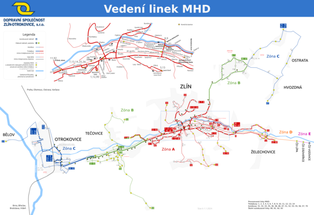
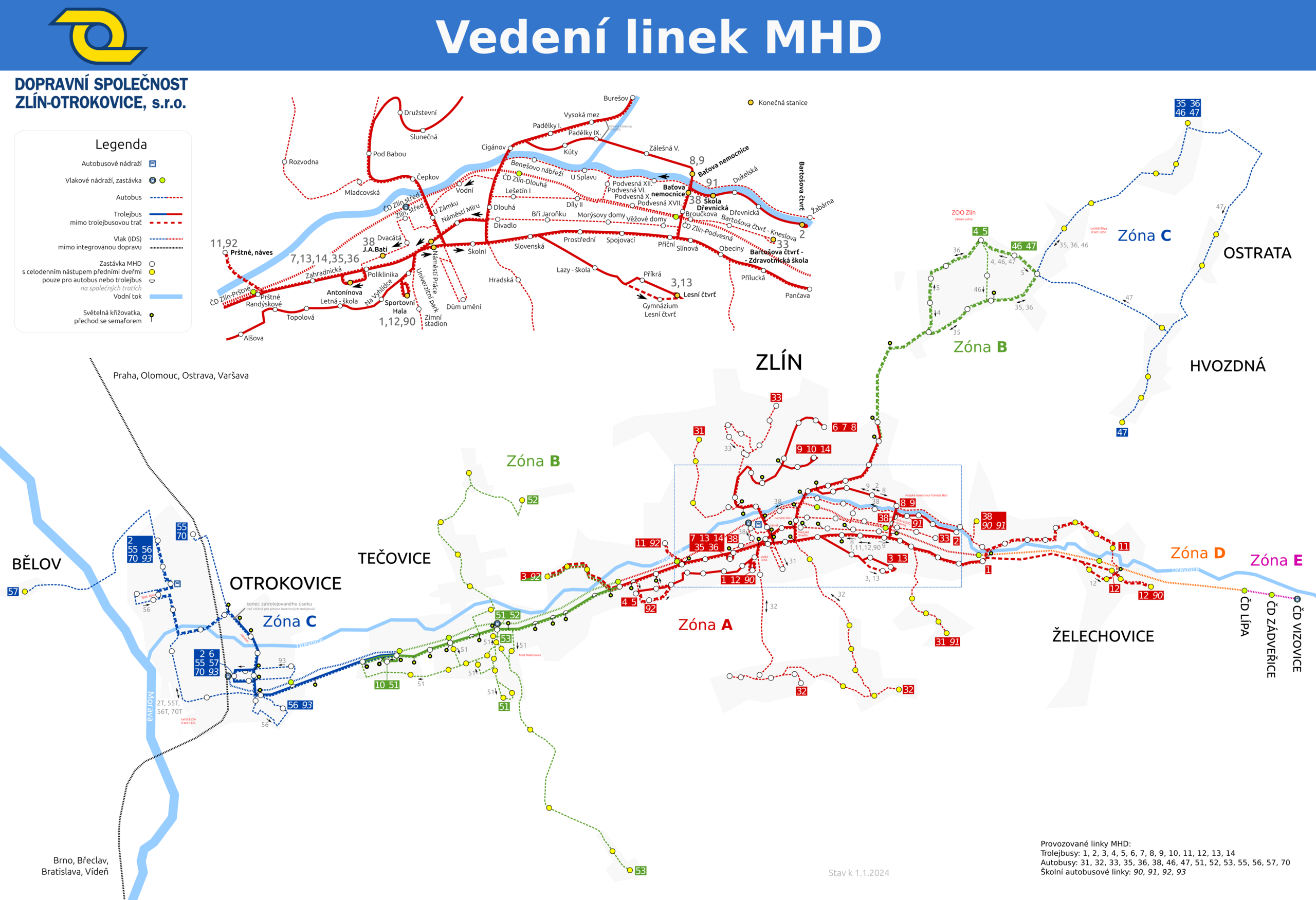
English: Zlín Public Transport map |
| Date | |
| Source | Own work |
| Author | Zubozrout |
| Other versions |
 |
Licensing[edit]
I, the copyright holder of this work, hereby publish it under the following license:
| This file is made available under the Creative Commons CC0 1.0 Universal Public Domain Dedication. | |
| The person who associated a work with this deed has dedicated the work to the public domain by waiving all of their rights to the work worldwide under copyright law, including all related and neighboring rights, to the extent allowed by law. You can copy, modify, distribute and perform the work, even for commercial purposes, all without asking permission.
|
File history
Click on a date/time to view the file as it appeared at that time.
| Date/Time | Thumbnail | Dimensions | User | Comment | |
|---|---|---|---|---|---|
| current | 13:31, 20 December 2023 | | 5,200 × 3,556 (2.18 MB) | Zubozrout (talk | contribs) | New bus line 53: https://www.zlin.eu/tiskove-zpravy/mhd-rozsiruje-si-autobusovych-linek-od-1-ledna-se-bude-jezdit-na-salas-6581 |
| 13:24, 10 December 2023 |  | 5,200 × 3,111 (2.13 MB) | Zubozrout (talk | contribs) | Add missing trolleybus stop: Kocanda, sídliště | |
| 19:58, 11 September 2023 |  | 5,200 × 3,111 (2.13 MB) | Zubozrout (talk | contribs) | Fix missing stops | |
| 20:05, 31 August 2023 |  | 5,200 × 3,111 (2.12 MB) | Zubozrout (talk | contribs) | Fixed mixed zones bus line 51 | |
| 19:54, 31 August 2023 |  | 5,200 × 3,111 (2.12 MB) | Zubozrout (talk | contribs) | Fixed line 51 and a few design tweaks to make the map less screaming with various colors | |
| 19:56, 28 August 2023 |  | 5,200 × 3,111 (2.12 MB) | Zubozrout (talk | contribs) | Fixed arrows in Otrokovice matching oficial DSZO map: https://www.dszo.cz/wp-content/uploads/2023/08/mapa_DSZO_web.pdf | |
| 19:49, 28 August 2023 |  | 5,200 × 3,111 (2.12 MB) | Zubozrout (talk | contribs) | New bus lines in Otrokovice (line 55xyz split into multiple separate ones), and other 2023 changes | |
| 15:55, 21 June 2022 |  | 5,200 × 3,111 (2.08 MB) | Zubozrout (talk | contribs) | Removal of bus line 53, updated line end points | |
| 11:37, 29 April 2022 |  | 5,200 × 3,111 (2.08 MB) | Zubozrout (talk | contribs) | Fix typos | |
| 11:26, 29 April 2022 |  | 5,200 × 3,111 (2.08 MB) | Zubozrout (talk | contribs) | Wired section extended in Otrokovice |
You cannot overwrite this file.
File usage on Commons
The following 35 pages use this file:
- User:Chumwa/OgreBot/Potential transport maps/2019 August 21-31
- User:Chumwa/OgreBot/Potential transport maps/2019 March 11-20
- User:Chumwa/OgreBot/Potential transport maps/2019 March 21-31
- User:Chumwa/OgreBot/Potential transport maps/2019 May 21-31
- User:Chumwa/OgreBot/Public transport information/2019 August 21-31
- User:Chumwa/OgreBot/Public transport information/2019 March 11-20
- User:Chumwa/OgreBot/Public transport information/2019 March 21-31
- User:Chumwa/OgreBot/Public transport information/2019 May 21-31
- User:Chumwa/OgreBot/Public transport information/2020 October 11-20
- User:Chumwa/OgreBot/Public transport information/2021 December 21-31
- User:Chumwa/OgreBot/Public transport information/2021 June 21-30
- User:Chumwa/OgreBot/Public transport information/2022 April 21-30
- User:Chumwa/OgreBot/Public transport information/2022 June 21-30
- User:Chumwa/OgreBot/Public transport information/2023 August 21-31
- User:Chumwa/OgreBot/Public transport information/2023 December 1-10
- User:Chumwa/OgreBot/Public transport information/2023 December 11-20
- User:Chumwa/OgreBot/Public transport information/2023 September 11-20
- User:Chumwa/OgreBot/Transport Maps/2019 August 21-31
- User:Chumwa/OgreBot/Transport Maps/2019 March 11-20
- User:Chumwa/OgreBot/Transport Maps/2019 March 21-31
- User:Chumwa/OgreBot/Transport Maps/2019 May 21-31
- User:Chumwa/OgreBot/Transport Maps/2020 October 11-20
- User:Chumwa/OgreBot/Transport Maps/2021 December 21-31
- User:Chumwa/OgreBot/Transport Maps/2021 June 21-30
- User:Chumwa/OgreBot/Transport Maps/2022 April 21-30
- User:Chumwa/OgreBot/Transport Maps/2022 June 21-30
- User:Chumwa/OgreBot/Transport Maps/2023 August 21-31
- User:Chumwa/OgreBot/Transport Maps/2023 December 1-10
- User:Chumwa/OgreBot/Transport Maps/2023 December 11-20
- User:Chumwa/OgreBot/Transport Maps/2023 September 11-20
- User:Chumwa/OgreBot/Travel and communication maps/2019 August 21-31
- User:Chumwa/OgreBot/Travel and communication maps/2019 March 11-20
- User:Chumwa/OgreBot/Travel and communication maps/2019 March 21-31
- User:Chumwa/OgreBot/Travel and communication maps/2019 May 21-31
- File:Plánek sítě MHD Zlín.svg
File usage on other wikis
The following other wikis use this file:
- Usage on cs.wikipedia.org
- Usage on ja.wikipedia.org