File:Pinatubo 1991-06-09.jpg

Pinatubo_1991-06-09.jpg (500 × 338 pixels, file size: 45 KB, MIME type: image/jpeg)
Captions
Captions
Summary[edit]
| Description |
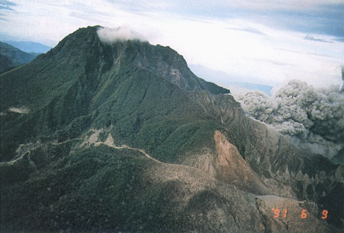
Pre-eruption Mount Pinatubo, viewed from the northeast. The April 2, 1991, phreatic explosion craters (lower right, adjacent to '91 in date stamp) and the eventual location of June 7-12 dome extrusion (beneath the ash cloud) were aligned northeast-southwest across the north face of Mount Pinatubo (map of craters in Wolfe and Hoblitt, this volume). The ridge in the foreground may have been the wall of a prehistoric caldera that was only slightly larger than that which formed in 1991. (R.P. Hoblitt, June 9, 1991) |
| Date | |
| Source |
https://pubs.usgs.gov/pinatubo/punong1/ https://pubs.usgs.gov/pinatubo/punong1/fig4a.jpg |
| Author | United States Geological Survey |
Licensing[edit]
This image is in the public domain in the United States because it only contains materials that originally came from the United States Geological Survey, an agency of the United States Department of the Interior. For more information, see the official USGS copyright policy.
|
File history
Click on a date/time to view the file as it appeared at that time.
| Date/Time | Thumbnail | Dimensions | User | Comment | |
|---|---|---|---|---|---|
| current | 10:52, 3 December 2018 | | 500 × 338 (45 KB) | Batholith (talk | contribs) | == {{int:filedesc}} == {{Information |Description= {{Quote box |Pre-eruption Mount Pinatubo, viewed from the northeast. The April 2, 1991, phreatic explosion craters (lower right, adjacent to '91 in date stamp) and the eventual location of June 7-12 dome extrusion (beneath the ash cloud) were aligned northeast-southwest across the north face of Mount Pinatubo (map of craters in Wolfe and Hoblitt, this volume). The ridge in the foreground may have been the wall of a pre... |
You cannot overwrite this file.
File usage on Commons
There are no pages that use this file.
File usage on other wikis
The following other wikis use this file:
- Usage on eo.wikipedia.org