File:Pima County Arizona USA Casas Adobes highlighted.svg
Jump to navigation
Jump to search

Size of this PNG preview of this SVG file: 453 × 599 pixels. Other resolutions: 181 × 240 pixels | 363 × 480 pixels | 580 × 768 pixels | 774 × 1,024 pixels | 1,548 × 2,048 pixels | 1,100 × 1,455 pixels.
Original file (SVG file, nominally 1,100 × 1,455 pixels, file size: 160 KB)
Captions
Captions
Add a one-line explanation of what this file represents
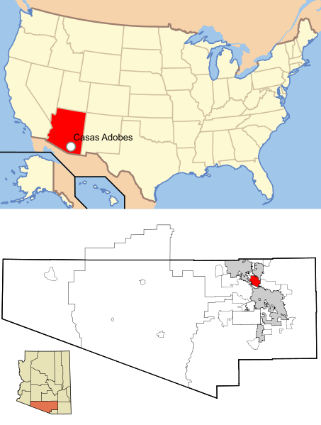
| Description | This map shows the incorporated areas and unincorporated areas in Pima County, Arizona. Incorporated cities are shown in gray and data for their borders and locations are based on the 2000/2030 PAG Transportation Analysis Zone Map. Casas Adobes is highlighted in red. Information for unincorporated locations and borders are based on the Census 2000 Pima County Tract Outline Index Map (PDF). I created this map in en:Inkscape. |
| Date | (UTC) |
| Source | |
| Author |
| This is a retouched picture, which means that it has been digitally altered from its original version. Modifications: Added location of Casas Adobes in United States. The original can be viewed here: Pima County Incorporated and Unincorporated areas Casas Adobes highlighted.svg:
|
This file is licensed under the Creative Commons Attribution-Share Alike 3.0 Unported license.
- You are free:
- to share – to copy, distribute and transmit the work
- to remix – to adapt the work
- Under the following conditions:
- attribution – You must give appropriate credit, provide a link to the license, and indicate if changes were made. You may do so in any reasonable manner, but not in any way that suggests the licensor endorses you or your use.
- share alike – If you remix, transform, or build upon the material, you must distribute your contributions under the same or compatible license as the original.
Original upload log[edit]
This image is a derivative work of the following images:
- File:Map_of_USA_AZ.svg licensed with Cc-by-2.0, Cc-by-sa-1.0, Cc-by-sa-2.0, Cc-by-sa-3.0-migrated-with-disclaimers, GFDL-en
- 2006-05-26T18:34:12Z Huebi 286x186 (171269 Bytes)
- 2006-05-26T08:48:00Z Huebi 959x593 (317355 Bytes) {{Information| |Description=Map of USA with Arizona highlighted |other_versions=[[:image:Map of USA with state names.svg]] }} [[Category:Maps of the United States]] [[Category:SVG maps]] {{GFDL-en}}{{cc-by-2.0}}{{cc-by-sa-1
- File:Pima_County_Incorporated_and_Unincorporated_areas_Casas_Adobes_highlighted.svg licensed with Cc-by-sa-2.5,2.0,1.0, Cc-by-sa-3.0-migrated, GFDL
- 2007-02-19T17:06:09Z Ixnayonthetimmay 1100x700 (61287 Bytes) {{Information |Description=This map shows the [[:w:Municipality|incorporated areas]] and [[:w:Unincorporated area|unincorporated areas]] in [[:w:Pima County, Arizona|Pima County]], [[:w:Arizona|Arizona]]. Incorporated cities
Uploaded with derivativeFX
File history
Click on a date/time to view the file as it appeared at that time.
| Date/Time | Thumbnail | Dimensions | User | Comment | |
|---|---|---|---|---|---|
| current | 19:09, 15 January 2011 | | 1,100 × 1,455 (160 KB) | Ras67 (talk | contribs) | cropped |
| 05:43, 10 January 2011 |  | 1,100 × 1,500 (176 KB) | Sswonk (talk | contribs) | Casas Adobes highlighted with white locator on US map | |
| 05:32, 10 January 2011 |  | 1,100 × 1,500 (176 KB) | Sswonk (talk | contribs) | {{Information |Description=This map shows the incorporated areas and unincorporated areas in Pima County, Arizona. Incorporated cities are shown in gray and data for |
You cannot overwrite this file.
File usage on Commons
There are no pages that use this file.
File usage on other wikis
The following other wikis use this file:
- Usage on fi.wikipedia.org
- Usage on ja.wikipedia.org
- Usage on mk.wikipedia.org
- Usage on ms.wikipedia.org
- Usage on simple.wikipedia.org
- Usage on th.wikipedia.org
- Usage on vi.wikipedia.org
- Usage on zh.wikipedia.org