File:Phjongbu vonal térkép.png
Jump to navigation
Jump to search

Size of this preview: 539 × 600 pixels. Other resolutions: 216 × 240 pixels | 431 × 480 pixels | 977 × 1,087 pixels.
Original file (977 × 1,087 pixels, file size: 29 KB, MIME type: image/png)
Captions
Captions
Add a one-line explanation of what this file represents
Summary[edit]
| Description |
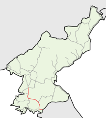
Magyar: Észak-Korea egyik legfontosabb vasútvonalának térképe.
한국어: 조선민주주의인민공화국의 중요한 선인 평부선의 지도입니다.
English: Map of Pyongbu line, one of the most important lines of North Korea. |
| Date | |
| Source |
This file was derived from: North korea railways.png |
| Author | Voland77 at German Wikipedia, Oppashi at Hungarian Wikipedia |
Licensing[edit]
| |
This work has been released into the public domain by its author, Oppashi, at the English Wikipedia project. This applies worldwide. In case this is not legally possible: |
Original upload log[edit]
The original description page was here. All following user names refer to hu.wikipedia.
| Date/Time | Dimensions | User | Comment |
|---|---|---|---|
| 2016-02-23 16:45 | 977×1087× (29605 bytes) | Oppashi | {{Információ | leírás = Észak-Korea egyik legfontosabb vasútvonalának térképe. | forrás = [[Fájl:North korea railways.png]] | dátum = 2016-02-23 | helyszín = | szerző = [[Szerkesztő:Oppashi]] | eng… |
File history
Click on a date/time to view the file as it appeared at that time.
| Date/Time | Thumbnail | Dimensions | User | Comment | |
|---|---|---|---|---|---|
| current | 13:36, 25 February 2016 | | 977 × 1,087 (29 KB) | Xing (talk | contribs) | There's no point to distinguish, as the Kaesong-Dorasan line belongs to the line. |
| 23:04, 23 February 2016 |  | 977 × 1,087 (29 KB) | Regasterios (talk | contribs) | Transferred from hu.wikipedia |
You cannot overwrite this file.
File usage on Commons
The following 4 pages use this file:
File usage on other wikis
The following other wikis use this file:
- Usage on cs.wikipedia.org
- Usage on de.wikipedia.org
- Usage on ja.wikipedia.org
- Usage on ko.wikipedia.org
- Usage on www.wikidata.org