File:PhiladelCampaignHessianMap.jpg

Original file (1,510 × 1,282 pixels, file size: 274 KB, MIME type: image/jpeg)
Captions
Captions
Summary[edit]
| Description |
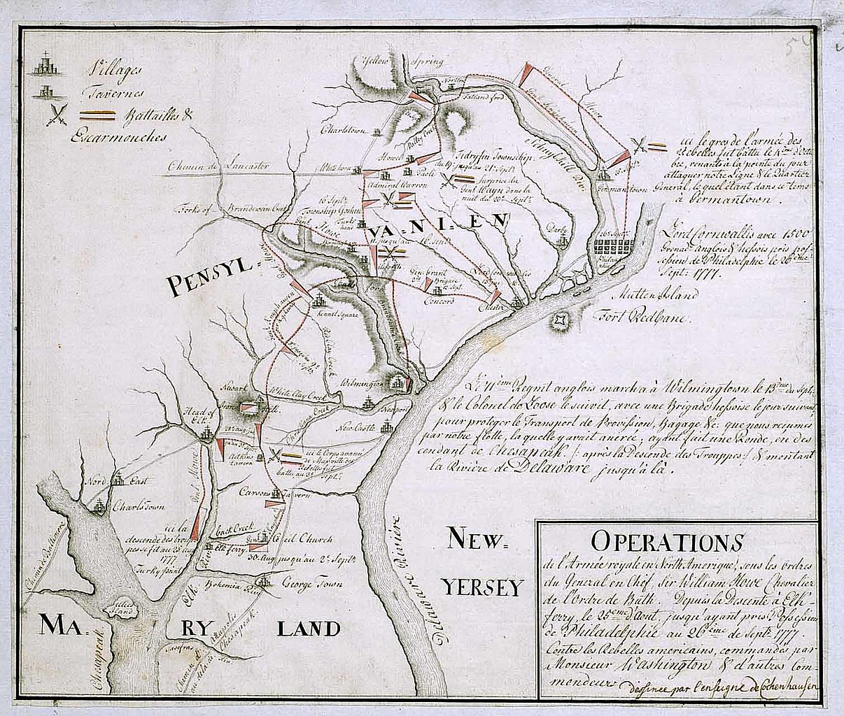
English: 18th century Hessian map from the Marburg State Library in Germany
of the Philadelphia Campaign (Battle of Brandywine, Forts Mercer and Redbank, Germantown, etc.) via the website of the West Jersey History Project http://westjerseyhistory.org/maps/revwarmaps/hessianmaps/index6.shtml Text in French, accompanying maps dated either 1777 or 1787 Quick translation"Operations of the royal army in North America under the orders of Sir William Howe, Knight of the Order of Bath. From the descent at Elk Ferry 25 August until taking possession of Philadelphia 26 September, 1777 against the american Rebels commandeed by Mr. Washington and other commanders. (Map) Designed by Ensign Cochenhausen" |
| Source | |
| Author |
Licensing[edit]
|
This is a faithful photographic reproduction of a two-dimensional, public domain work of art. The work of art itself is in the public domain for the following reason:
The official position taken by the Wikimedia Foundation is that "faithful reproductions of two-dimensional public domain works of art are public domain". This photographic reproduction is therefore also considered to be in the public domain in the United States. In other jurisdictions, re-use of this content may be restricted; see Reuse of PD-Art photographs for details. {{PD-Art}} template without license parameter: please specify why the underlying work is public domain in both the source country and the United States
(Usage: {{PD-Art|1=|deathyear=''year of author's death''|country=''source country''}}, where parameter #1 can be PD-old-auto, PD-old-auto-expired, PD-old-auto-1996, PD-old-100 or similar. See Commons:Multi-license copyright tags for more information.) | ||||
Original upload log[edit]
- 2008-01-12 16:39 Smallbones 1510×1282×??? (280724 bytes) 18th century Hessian map from the Marburg State Library in Germany of the Philadelphia Campaign (Battle of Brandywine, Forts Mercer and Redbank, Germantown, etc.) via the website of the West Jersey History Project http://westjerseyhistory.org/maps/revwarm
File history
Click on a date/time to view the file as it appeared at that time.
| Date/Time | Thumbnail | Dimensions | User | Comment | |
|---|---|---|---|---|---|
| current | 21:23, 20 August 2008 | | 1,510 × 1,282 (274 KB) | File Upload Bot (Magnus Manske) (talk | contribs) | {{BotMoveToCommons|en.wikipedia}} {{Information |Description={{en|18th century Hessian map from the Marburg State Library in Germany of the Philadelphia Campaign (Battle of Brandywine, Forts Mercer and Redbank, Germantown, etc.) via the website of the We |
You cannot overwrite this file.
File usage on Commons
There are no pages that use this file.
File usage on other wikis
The following other wikis use this file:
- Usage on azb.wikipedia.org
- Usage on ca.wikipedia.org
- Usage on cs.wikipedia.org
- Usage on da.wikipedia.org
- Usage on en.wikipedia.org
- Usage on es.wikipedia.org
- Usage on fa.wikipedia.org
- Usage on fi.wikipedia.org
- Usage on fr.wikipedia.org
- Usage on gl.wikipedia.org
- Usage on it.wikipedia.org
- Usage on ja.wikipedia.org
- Usage on ko.wikipedia.org
- Usage on pl.wikipedia.org
- Usage on pt.wikipedia.org
- Usage on ro.wikipedia.org
- Usage on ru.wikipedia.org
- Usage on zh.wikipedia.org
Metadata
- Battle of Brandywine
- Maps of the Philadelphia Campaign
- Pennsylvania in the American Revolution
- 1777 maps of Pennsylvania
- 1777 maps of Delaware
- 1777 maps of Maryland
- American Revolution in 1777
- French-language maps of North America
- British Occupation of Philadelphia
- German military personnel of the American Revolutionary War