File:Pfersag-Wasserfall-20200308-RM-113024.jpg
Original file (10,368 × 7,378 pixels, file size: 49.18 MB, MIME type: image/jpeg)
Captions
Summary[edit]
Warning | The original file is very high-resolution. It might not load properly or could cause your browser to freeze when opened at full size. |
---|
DescriptionPfersag-Wasserfall-20200308-RM-113024.jpg |
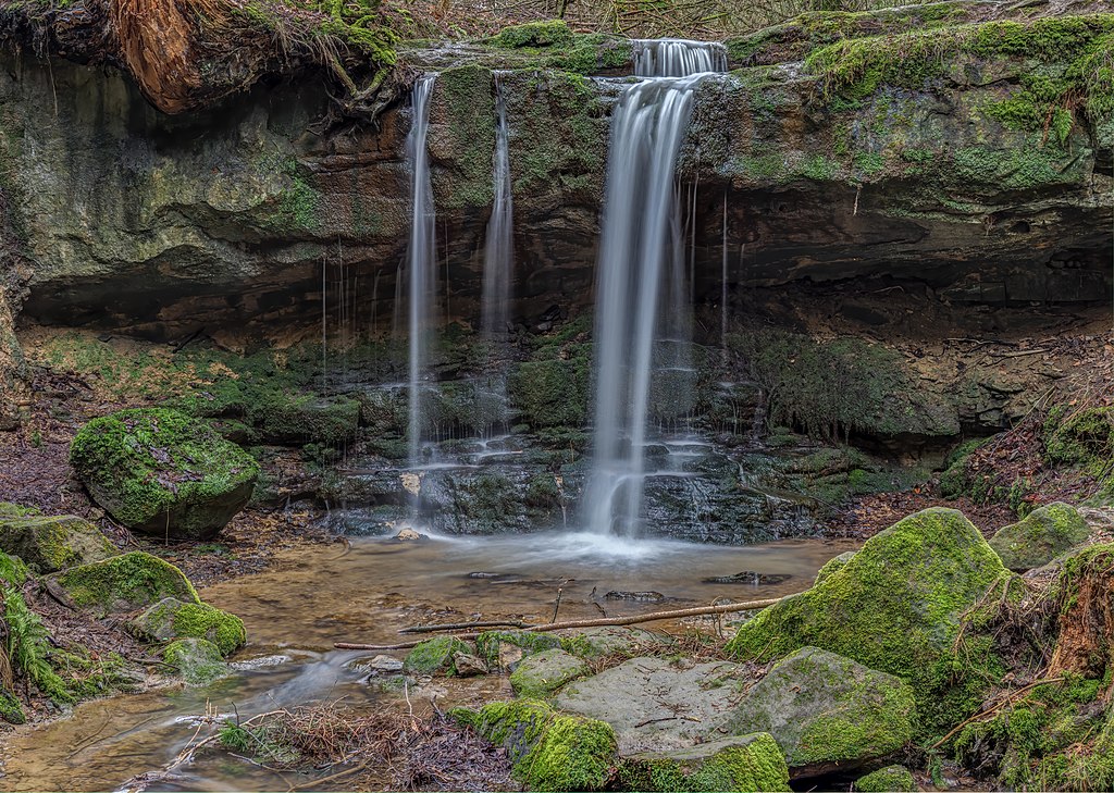
English: Pfersag waterfall in the district of Lichtenfels in Upper Franconia
Deutsch: Pfersag Wasserfall im Landkreis Lichtenfels in Oberfranken |
||||||
Date | |||||||
Source | Own work | ||||||
Author | Ermell | ||||||
Permission (Reusing this file) |
|
Camera location | 50° 10′ 12.3″ N, 11° 15′ 41.58″ E | View this and other nearby images on: OpenStreetMap | 50.170082; 11.261549 |
---|
|
This image was uploaded as part of Wiki Loves Earth 2020.
aragonés ∙ العربية ∙ asturianu ∙ azərbaycanca ∙ беларуская (тарашкевіца) ∙ български ∙ বাংলা ∙ brezhoneg ∙ català ∙ čeština ∙ Cymraeg ∙ Deutsch ∙ Ελληνικά ∙ English ∙ español ∙ eesti ∙ euskara ∙ فارسی ∙ français ∙ galego ∙ עברית ∙ hrvatski ∙ հայերեն ∙ Bahasa Indonesia ∙ italiano ∙ 日本語 ∙ ქართული ∙ 한국어 ∙ latviešu ∙ македонски ∙ മലയാളം ∙ मराठी ∙ Bahasa Melayu ∙ norsk bokmål ∙ नेपाली ∙ Nederlands ∙ norsk ∙ polski ∙ português ∙ português do Brasil ∙ română ∙ русский ∙ sicilianu ∙ shqip ∙ slovenščina ∙ српски / srpski ∙ svenska ∙ ไทย ∙ Türkçe ∙ українська ∙ اردو ∙ 简体中文 ∙ 繁體中文 ∙ +/− |
Licensing[edit]
- You are free:
- to share – to copy, distribute and transmit the work
- to remix – to adapt the work
- Under the following conditions:
- attribution – You must give appropriate credit, provide a link to the license, and indicate if changes were made. You may do so in any reasonable manner, but not in any way that suggests the licensor endorses you or your use.
- share alike – If you remix, transform, or build upon the material, you must distribute your contributions under the same or compatible license as the original.
This image has been assessed using the Quality image guidelines and is considered a Quality image.
العربية ∙ جازايرية ∙ беларуская ∙ беларуская (тарашкевіца) ∙ български ∙ বাংলা ∙ català ∙ čeština ∙ Cymraeg ∙ Deutsch ∙ Schweizer Hochdeutsch ∙ Zazaki ∙ Ελληνικά ∙ English ∙ Esperanto ∙ español ∙ eesti ∙ euskara ∙ فارسی ∙ suomi ∙ français ∙ galego ∙ עברית ∙ हिन्दी ∙ hrvatski ∙ magyar ∙ հայերեն ∙ Bahasa Indonesia ∙ italiano ∙ 日本語 ∙ Jawa ∙ ქართული ∙ 한국어 ∙ kurdî ∙ Lëtzebuergesch ∙ lietuvių ∙ македонски ∙ മലയാളം ∙ मराठी ∙ Bahasa Melayu ∙ Nederlands ∙ Norfuk / Pitkern ∙ polski ∙ português ∙ português do Brasil ∙ rumantsch ∙ română ∙ русский ∙ sicilianu ∙ slovenčina ∙ slovenščina ∙ shqip ∙ српски / srpski ∙ svenska ∙ தமிழ் ∙ తెలుగు ∙ ไทย ∙ Tagalog ∙ Türkçe ∙ toki pona ∙ українська ∙ vèneto ∙ Tiếng Việt ∙ 中文 ∙ 中文(简体) ∙ 中文(繁體) ∙ +/− |
File history
Click on a date/time to view the file as it appeared at that time.
Date/Time | Thumbnail | Dimensions | User | Comment | |
---|---|---|---|---|---|
current | 14:28, 11 May 2020 | 10,368 × 7,378 (49.18 MB) | Ermell (talk | contribs) | Uploaded with LrMediaWiki 0.8.0, LR 9.2.1 Win |
You cannot overwrite this file.
File usage on Commons
The following 15 pages use this file:
- User:Firefly/2020-A
- Commons:Featured picture candidates/File:Pfersag-Wasserfall-20200308-RM-113024.jpg
- Commons:Featured picture candidates/Log/June 2020
- Commons:Featured pictures/Places/Natural/Germany
- Commons:Featured pictures/chronological/2020-A
- Commons:Featured pictures/chronological/June 2020
- Commons:Picture of the Year/2020/Candidates
- Commons:Picture of the Year/2020/R1/Gallery/2020-A
- Commons:Picture of the Year/2020/R1/Gallery/ALL
- Commons:Picture of the Year/2020/R1/Gallery/M06
- Commons:Picture of the Year/2020/R1/Gallery/Waters
- Commons:Picture of the Year/2020/R1/v/Pfersag-Wasserfall-20200308-RM-113024.jpg
- Commons:Quality images/Subject/Places/Natural structures/archive 2020
- Commons:Quality images candidates/Archives May 16 2020
- File:Pfersag-Wasserfall-20200308-RM-113024.jpg
File usage on other wikis
The following other wikis use this file:
- Usage on de.wikipedia.org
- Usage on fr.wikipedia.org
Metadata
This file contains additional information such as Exif metadata which may have been added by the digital camera, scanner, or software program used to create or digitize it. If the file has been modified from its original state, some details such as the timestamp may not fully reflect those of the original file. The timestamp is only as accurate as the clock in the camera, and it may be completely wrong.
Camera manufacturer | OLYMPUS CORPORATION |
---|---|
Camera model | E-M1MarkII |
Copyright holder |
|
Exposure time | 3/10 sec (0.3) |
F-number | f/7.1 |
ISO speed rating | 64 |
Date and time of data generation | 11:30, 8 March 2020 |
Lens focal length | 24 mm |
Latitude | 50° 10′ 12.29″ N |
Longitude | 11° 15′ 41.58″ E |
Altitude | 421 meters above sea level |
Author | reinhold möller |
City shown | Burgkunstadt |
Horizontal resolution | 240 dpi |
Vertical resolution | 240 dpi |
Software used | Adobe Photoshop Lightroom Classic 9.2.1 (Windows) |
File change date and time | 16:28, 11 May 2020 |
Exposure Program | Aperture priority |
Exif version | 2.31 |
Date and time of digitizing | 11:28, 8 March 2020 |
APEX shutter speed | 1.736966 |
APEX aperture | 5.655638 |
APEX exposure bias | −2 |
Maximum land aperture | 4 APEX (f/4) |
Metering mode | Pattern |
Light source | Unknown |
Flash | Flash did not fire, compulsory flash firing |
Color space | sRGB |
File source | Digital still camera |
Custom image processing | Normal process |
Exposure mode | Manual exposure |
White balance | Auto white balance |
Digital zoom ratio | 1 |
Focal length in 35 mm film | 48 mm |
Scene capture type | Standard |
Scene control | None |
Contrast | Normal |
Saturation | Normal |
Sharpness | Normal |
GPS tag version | 0.0.2.2 |
Serial number of camera | BHUA05919 |
Lens used | OLYMPUS M.12-100mm F4.0 |
Date metadata was last modified | 18:28, 11 May 2020 |
Unique ID of original document | D17632CA1D50F63EC2CF3702C7B50DF7 |
Copyright status | Copyrighted |
Contact information |
|
Province or state shown | Bayern |
Country shown | Deutschland |
Code for country shown | DE |
IIM version | 4 |
Structured data
Items portrayed in this file
depicts
50°10'12.29376"N, 11°15'41.57518"E
0.3 second
7.1
24 millimetre
image/jpeg
- Large images
- Photographs by Ermell
- Files with coordinates missing SDC location of creation (50° N, 11° E)
- Featured pictures on Wikimedia Commons
- Images from Wiki Loves Earth 2020
- Images from Wiki Loves Earth 2020 in Germany
- Images from Wiki Loves Earth missing SDC location of creation
- Images from Wiki Loves Earth missing SDC inception
- CC-BY-SA-4.0
- Self-published work
- Quality images
- Quality images missing SDC inception
- Bavaria photographs taken on 2020-03-08
- Images from Wiki Loves Earth 2020, DE-BY
- Images by User:Ermell taken in 2020
- Taken with Olympus E-M1 Mark II
- Taken with Olympus M.Zuiko Digital ED 12-100mm f/4 PRO
- Quality images by Ermell
- Uploaded with LrMediaWiki
- Quality images of Upper Franconia by Ermell
- Exposure time 1/3 sec
- Featured pictures by Ermell
- Featured pictures of nature by Ermell
- Quality images from Wiki Loves Earth 2020 in Germany
- Featured pictures from Wiki Loves Earth 2020 in Germany
- Quality images with long exposure
- Pages with maps