File:Persian Gulf, Oman and Central Arabia map by F.F. Hunder 1905-2.jpg
Jump to navigation
Jump to search

Size of this preview: 800 × 600 pixels. Other resolutions: 320 × 240 pixels | 640 × 480 pixels | 1,024 × 768 pixels | 1,280 × 960 pixels | 2,560 × 1,920 pixels | 7,954 × 5,964 pixels.
Original file (7,954 × 5,964 pixels, file size: 26.92 MB, MIME type: image/jpeg)
Captions
Captions
Add a one-line explanation of what this file represents
Summary[edit]
| Description |
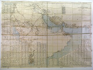
English: *Map of the Persian Gulf, ’Omān and Central Arabia
|
| Date | |
| Source | https://www.qdl.qa/en/archive/81055/vdc_100023514411.0x000008 |
| Author | F.F. Hunder, I.A. Survey of India, in Consultation with J.G. Lorimer, I.C.S., & Capt. M. O’C. Tandy, R.E. |
| Other versions |
|
.jpg)
Licensing[edit]
|
This work is in the public domain in its country of origin and other countries and areas where the copyright term is the author's life plus 100 years or fewer. This work is in the public domain in the United States because it was published (or registered with the U.S. Copyright Office) before January 1, 1929. | |
| This file has been identified as being free of known restrictions under copyright law, including all related and neighboring rights. | |
File history
Click on a date/time to view the file as it appeared at that time.
| Date/Time | Thumbnail | Dimensions | User | Comment | |
|---|---|---|---|---|---|
| current | 08:41, 17 November 2017 | | 7,954 × 5,964 (26.92 MB) | Ralf Roletschek (talk | contribs) | =={{int:filedesc}}== {{Information |description={{en|1= *Map of the Persian Gulf, ’Omān and Central Arabia *part of en:Gazetteer of the Persian Gulf, Oman and Central Arabia *Download and stitching by User:Pemu using [https://commonsarchive... |
You cannot overwrite this file.
File usage on Commons
The following 2 pages use this file:
File usage on other wikis
The following other wikis use this file:
- Usage on de.wikipedia.org