File:Perineu Aragonés (orografía).png
Jump to navigation
Jump to search

Size of this preview: 800 × 555 pixels. Other resolutions: 320 × 222 pixels | 640 × 444 pixels | 1,024 × 710 pixels | 1,187 × 823 pixels.
Original file (1,187 × 823 pixels, file size: 3.73 MB, MIME type: image/png)
Captions
Captions
Add a one-line explanation of what this file represents
Summary[edit]
.png&action=edit§ion=1)
| Description |
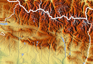
Español: Perineu Aragonés (orografía)
Español: Pirineo Aragonés (orografía) |
| Date | |
| Source | www.maps-for-free.com |
| Author | Willtron |
Licensing[edit]
.png&action=edit§ion=2)

|
Permission is granted to copy, distribute and/or modify this document under the terms of the GNU Free Documentation License, Version 1.2 or any later version published by the Free Software Foundation; with no Invariant Sections, no Front-Cover Texts, and no Back-Cover Texts. A copy of the license is included in the section entitled GNU Free Documentation License. |
| This file is licensed under the Creative Commons Attribution-Share Alike 3.0 Unported license. | ||
| ||
| This licensing tag was added to this file as part of the GFDL licensing update. |
File history
Click on a date/time to view the file as it appeared at that time.
| Date/Time | Thumbnail | Dimensions | User | Comment | |
|---|---|---|---|---|---|
| current | 14:30, 27 March 2019 | | 1,187 × 823 (3.73 MB) | Willtron (talk | contribs) | Hydrology |
| 14:50, 15 February 2019 |  | 1,187 × 823 (1.87 MB) | Willtron (talk | contribs) | ||
| 13:28, 15 February 2019 |  | 1,187 × 823 (1.87 MB) | Willtron (talk | contribs) | ||
| 13:26, 15 February 2019 |  | 1,187 × 823 (1.7 MB) | Willtron (talk | contribs) | More contrast on borders | |
| 19:15, 19 September 2009 |  | 712 × 494 (778 KB) | Willtron (talk | contribs) | {{Information |Description={{es|Perineu Aragonés (orografía)}} {{es|Pirineo Aragonés (orografía)}} |Source=[http://www.maps-for-free.com/ www.maps-for-free.com] |Author=Willtron |Date=19-IX-2009 |Permission= |other_versions= }} == { |
You cannot overwrite this file.
File usage on Commons
The following page uses this file:
File usage on other wikis
The following other wikis use this file:
- Usage on an.wikipedia.org
- Midi d'Osal
- As Tres Serols
- Punda de ro Faixón
- Punda de ro Corral Ciego
- Pico Moros
- Mallo de Marmorés
- Punda de Camachibosa
- Somport
- Sierra de Sant Visorio
- Penya Montanyesa
- Penya Uruel
- Sestrals
- Castiello Mayor
- Punta Lierga
- Sierra de Guara
- Sestral Baixa
- Sestral d'o Reguero
- Sestral Alta
- Punta Bacials
- Sierra de Sant Martín d'a Solana
- Punta Palomera
- O Portalet de ra Nieu
- Cruceta de Yeba
- Punta Nabaín
- Penya Solano
- Puerto de Marcadau
- Punta Escarra
- Pico d'Anayet
- Sierra de Gratal
- Penya Gratal
- Puerto de Cotefablo
- Breca de Roldán
- Tuca d'Aneto
- Punta de Lardana
- Tuca d'el Perdiguero
- Tuca de la Maladeta
- Punta Maristás
- Punda de ro Clot de ra Fuent
- Punda de ra Faixa
- Tuca de les Espades
- Puerto de Palo
- Meseta d'os Tres Reis
- Pico Plan de Marmorés
- Penya Foratata
- Punta de Treserols
- Sierra d'Arro
- Penya Collarada
- Ibón de Cap de Toro
- Ibón de Sabocos
- Ibons d'Anayet
View more global usage of this file.
.png)
.png&oldid=784648459)