File:Peloponnesian war alliances 431 BC.png
Jump to navigation
Jump to search
Size of this preview: 387 × 600 pixels. Other resolutions: 155 × 240 pixels | 482 × 747 pixels.
Original file (482 × 747 pixels, file size: 37 KB, MIME type: image/png)
Captions
Captions
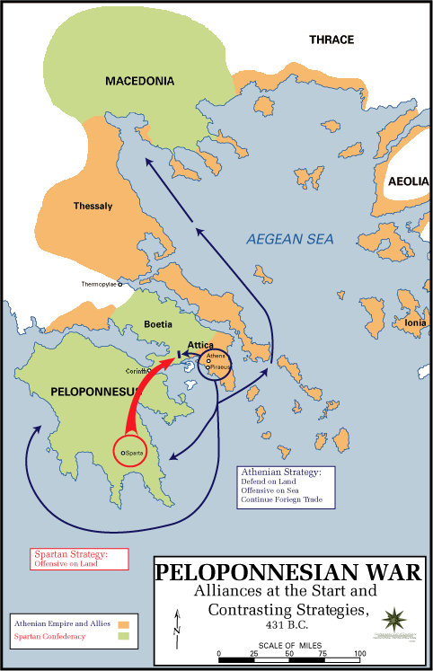
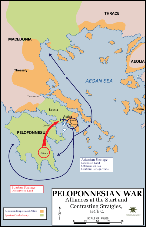
Alliances of the Peloponnesian War
Summary[edit]

|
File:Guerre del Peloponneso 431aC mappa.svg is a vector version of this file. It should be used in place of this PNG file when not inferior.
File:Peloponnesian war alliances 431 BC.png → File:Guerre del Peloponneso 431aC mappa.svg
For more information, see Help:SVG. |
 |
| Description |
English: The Alliances of the Peloponnesian War |
| Date | 5 May 2009 (original upload date) |
| Source |
|
| Author | U.S. Army Cartographer, as amended by uploader to correct spelling mistake |
| Permission (Reusing this file) |
Public domain as a work of the U.S. military.; amendments also released into the public domain |
| Other versions |
|
Licensing[edit]
This work is in the public domain in the United States because it is a work prepared by an officer or employee of the United States Government as part of that person’s official duties under the terms of Title 17, Chapter 1, Section 105 of the US Code.
Note: This only applies to original works of the Federal Government and not to the work of any individual U.S. state, territory, commonwealth, county, municipality, or any other subdivision. This template also does not apply to postage stamp designs published by the United States Postal Service since 1978. (See § 313.6(C)(1) of Compendium of U.S. Copyright Office Practices). It also does not apply to certain US coins; see The US Mint Terms of Use.
|
 | |
| This file has been identified as being free of known restrictions under copyright law, including all related and neighboring rights. | ||
Original upload log[edit]
The original description page was here. All following user names refer to en.wikipedia.
- 2009-05-05 11:43 The Anome 482×747× (34269 bytes) Fixed second spelling mistake, which had been accidentally reinstated by reverting to original source.
- 2009-05-05 11:28 The Anome 482×747× (34263 bytes) {{Information |Description = The Alliances of the Peloponnesian War |Source = http://www.faculty.umb.edu/gary_zabel/Courses/Phil%20281b/Maps/peloponnesian_war_alliances.gif |Date = |Author = U.S. Army Cartographer, as ame
File history
Click on a date/time to view the file as it appeared at that time.
| Date/Time | Thumbnail | Dimensions | User | Comment | |
|---|---|---|---|---|---|
| current | 19:35, 30 March 2018 | | 482 × 747 (37 KB) | Trecătorul răcit (talk | contribs) | Gulf of Pella in the time, position of names |
| 12:03, 5 May 2009 |  | 482 × 747 (33 KB) | File Upload Bot (Magnus Manske) (talk | contribs) | {{BotMoveToCommons|en.wikipedia|year={{subst:CURRENTYEAR}}|month={{subst:CURRENTMONTHNAME}}|day={{subst:CURRENTDAY}}}} {{Information |Description={{en|The Alliances of the Peloponnesian War}} |Source=Transferred from [http://en.wikipedia.org en.wikipedia |
You cannot overwrite this file.
File usage on Commons
The following 2 pages use this file:
File usage on other wikis
The following other wikis use this file:
- Usage on ar.wikipedia.org
- Usage on br.wikipedia.org
- Usage on ca.wikipedia.org
- Usage on da.wikipedia.org
- Usage on el.wikipedia.org
- Usage on en.wikipedia.org
- Usage on et.wikipedia.org
- Usage on eu.wikipedia.org
- Usage on fa.wikipedia.org
- Usage on fi.wikipedia.org
- Usage on fr.wikipedia.org
- Usage on hyw.wikipedia.org
- Usage on id.wikibooks.org
- Usage on it.wikipedia.org
- Usage on ka.wikipedia.org
- Usage on ko.wikipedia.org
- Usage on lv.wikipedia.org
- Usage on ml.wikipedia.org
- Usage on ro.wikipedia.org
- Usage on ru.wikipedia.org
- Usage on sh.wikipedia.org
- Usage on sk.wikipedia.org
- Usage on sq.wikipedia.org
- Usage on sr.wikipedia.org
- Usage on ta.wikipedia.org
- Usage on th.wikipedia.org
- Usage on tr.wikipedia.org
- Usage on vi.wikipedia.org
- Usage on xmf.wikipedia.org
- Usage on yo.wikipedia.org
- Usage on zh-yue.wikipedia.org
- Usage on zh.wikipedia.org
- Usage on zh.wikibooks.org