File:Peene Wasserstände bei Rückfluss.png
Jump to navigation
Jump to search

Size of this preview: 800 × 283 pixels. Other resolutions: 320 × 113 pixels | 640 × 226 pixels | 1,024 × 362 pixels | 1,280 × 452 pixels | 3,000 × 1,060 pixels.
Original file (3,000 × 1,060 pixels, file size: 73 KB, MIME type: image/png)
Captions
Captions
Add a one-line explanation of what this file represents
Summary[edit]
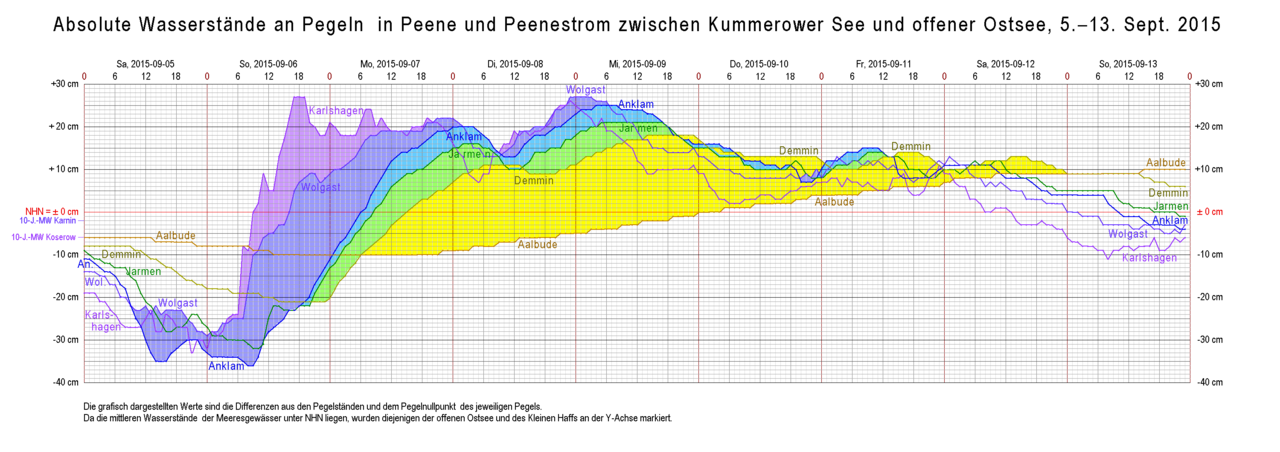
| Description | Water levels at various sites along Peene river and Peenestrom inlet duriung a phase of reverse flow in September 2015 |
| Date | |
| Source | Own work, based on data from WSV Stralsund and StALU Mecklenburgische Seenplatte |
| Author | Ulamm (talk) 12:56, 18 July 2016 (UTC) |
Licensing[edit]
I, the copyright holder of this work, hereby publish it under the following licenses:

|
Permission is granted to copy, distribute and/or modify this document under the terms of the GNU Free Documentation License, Version 1.2 or any later version published by the Free Software Foundation; with no Invariant Sections, no Front-Cover Texts, and no Back-Cover Texts. A copy of the license is included in the section entitled GNU Free Documentation License. |
This file is licensed under the Creative Commons Attribution-Share Alike Attribution-Share Alike 4.0 International, 3.0 Unported, 2.5 Generic, 2.0 Generic and 1.0 Generic license.
- You are free:
- to share – to copy, distribute and transmit the work
- to remix – to adapt the work
- Under the following conditions:
- attribution – You must give appropriate credit, provide a link to the license, and indicate if changes were made. You may do so in any reasonable manner, but not in any way that suggests the licensor endorses you or your use.
- share alike – If you remix, transform, or build upon the material, you must distribute your contributions under the same or compatible license as the original.
You may select the license of your choice.
File history
Click on a date/time to view the file as it appeared at that time.
| Date/Time | Thumbnail | Dimensions | User | Comment | |
|---|---|---|---|---|---|
| current | 06:19, 20 July 2016 | 3,000 × 1,060 (73 KB) | Ulamm (talk | contribs) | 10 years mean level at Koserow | |
| 12:56, 18 July 2016 | 3,000 × 1,060 (73 KB) | Ulamm (talk | contribs) | {{Information |Description=Water levels at various sites along Peene river and Peenestrom inlet durgung a phase of reverse flow in September 2015 |Source={{own]], based on dates form WSV Stralsund and StALU Mecklenburgische Seenplatte |Date=2016-07-18... |
You cannot overwrite this file.
File usage on Commons
There are no pages that use this file.
File usage on other wikis
The following other wikis use this file: