File:Peel-Commission Report Map1 AdminDistrictsSyriaPalestine 1154x1846.png
Jump to navigation
Jump to search

Size of this preview: 375 × 600 pixels. Other resolutions: 150 × 240 pixels | 300 × 480 pixels | 480 × 768 pixels | 1,154 × 1,846 pixels.
Original file (1,154 × 1,846 pixels, file size: 36 KB, MIME type: image/png)
Captions
Captions
Add a one-line explanation of what this file represents
| Description |
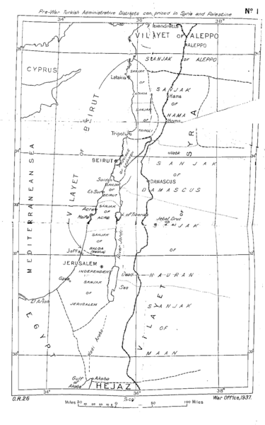
English: Pre-war Turkish Administrative Districts comprised in Syria and Palestine. Map No. 1 of the Peel Commission Report, presented to illustrate the Vilayets and Sandjaks mentioned in the 1915-10-24 en:McMahon Letters (McMahon Pledge, see also en:McMahon–Hussein Correspondence), showing the Ottoman adminstrative divisions.
This is the original scan from the scanned copy of the Peel Report as found on the UNISPAL library of the United Nations. |
|||
| Date | ||||
| Source | Palestine Royal Commission (Peel Commission), Report, Presented by the Secretary of State for the Colonies to Parliament by Command of His Majesty, July 1937. London, His Majesty's Stationary Office, 1937 Download as PDF from UNISPAL:UN.ORG | |||
| Author | British War Office, 1937 | |||
| Permission (Reusing this file) |
|


This file was derived from: Pre-war Turkish Administrative Districts comprised in Syria and Palestine of Peel Commission Report 1937.tif
| This is a retouched picture, which means that it has been digitally altered from its original version. Modifications: Shadows from wrinkles and crinkles which resulted from folding of the original copy have been cleaned out as much as possible. Unfortunately this was done with a reduced version of the original file. In the larger, the TIF, the mouse danced too much. "Upload a new version of this file" was not possible because this one is PNG while the first upload is TIF.
|
File history
Click on a date/time to view the file as it appeared at that time.
| Date/Time | Thumbnail | Dimensions | User | Comment | |
|---|---|---|---|---|---|
| current | 11:04, 31 January 2016 | | 1,154 × 1,846 (36 KB) | L.Willms (talk | contribs) | {{Information |Description ={{en|1=Pre-war Turkish Administrative Districts comprised in Syria and Palestine. Map No. 1 of the Peel Commission Report, presented to illustrate the Vilayets and Sandjaks mentioned in the 1915-10-24 [[:en:McMahon Letter... |
You cannot overwrite this file.
File usage on Commons
The following 8 pages use this file:
- User:J budissin/Uploads/BiH/2016 January 21-31
- User:Jaqeli/Georgia
- File:McMahon letter 'districts'.png
- File:Mount Lebanon, Ottoman Syria 1914.png
- File:Ottoman levant.png
- File:Peel-Commission Report Map1 AdminDistrictsSyriaPalestine 1154x184..png (file redirect)
- File:Pre-war Turkish Administrative Districts comprised in Syria and Palestine of Peel Commission Report 1937.tif
- File:ولايات سورية العثمانية حتى 1917.png
File usage on other wikis
The following other wikis use this file:
- Usage on en.wikipedia.org
- Usage on hy.wikipedia.org