File:Path of the Wounded history sign 3.JPG

Original file (4,608 × 3,072 pixels, file size: 8.72 MB, MIME type: image/jpeg)
Captions
Captions
Summary[edit]
| Description |
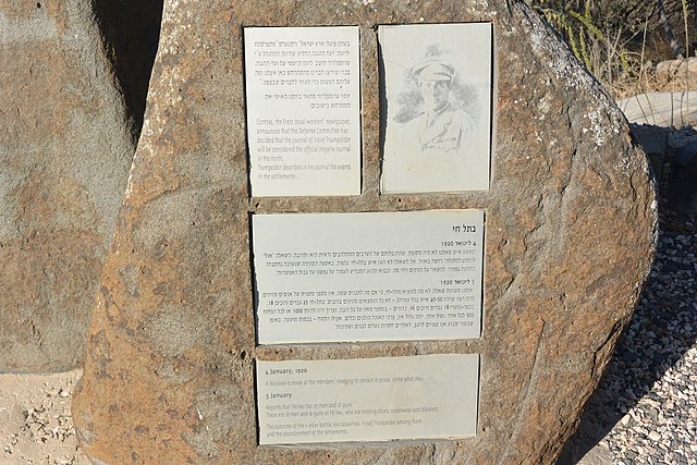
Deutsch: Englischer Teil des oberen Schilds
Auf dem untersten Schild steht in englisch geschrieben:
English: English part of the top sign:
At the bottom sign is written:
|
| Date | |
| Source | Own work |
| Author | Jotpe |
| Other versions |
|
| Place[1] | Deutsch: מסעף כפר גלעדי, 9977, Galil Elyon Regional Council, Nordbezirk, Israel English: מסעף כפר גלעדי, 9977, Galil Elyon Regional Council, North District, Israel עברית: מסעף כפר גלעדי, 9977, מועצה אזורית גליל עליון, מחוז הצפון, ישראל |
| Image Number | 67 |

| Camera location | | View this and other nearby images on: OpenStreetMap |
|---|
[edit]
-
 Path of the Wounded history sign 2.JPG
 -
 Path of the Wounded history sign 3.JPG
 -
 Path of the Wounded history sign 4.JPG
 -
 Tel Hai Sculpture Garden sign.JPG
 -
 Tel Hai Sculpture Garden.JPG
 -
 Path of the Wounded history sign 1.JPG


The production, editing or release of this file was supported by the Community-Budget of Wikimedia Deutschland. To see other files made with the support of Wikimedia Deutschland, please see the category Supported by Wikimedia Deutschland. |
Licensing[edit]
- You are free:
- to share – to copy, distribute and transmit the work
- to remix – to adapt the work
- Under the following conditions:
- attribution – You must give appropriate credit, provide a link to the license, and indicate if changes were made. You may do so in any reasonable manner, but not in any way that suggests the licensor endorses you or your use.
- share alike – If you remix, transform, or build upon the material, you must distribute your contributions under the same or compatible license as the original.
[edit]
Sources[edit]
File history
Click on a date/time to view the file as it appeared at that time.
| Date/Time | Thumbnail | Dimensions | User | Comment | |
|---|---|---|---|---|---|
| current | 20:51, 23 January 2015 | | 4,608 × 3,072 (8.72 MB) | Jotpe (talk | contribs) |
You cannot overwrite this file.
File usage on Commons
The following 7 pages use this file:
- User:Nicolas Rück (WMDE)/Supported by Wikimedia Deutschland 2015/3
- File:Path of the Wounded history sign 1.JPG
- File:Path of the Wounded history sign 2.JPG
- File:Path of the Wounded history sign 3.JPG
- File:Path of the Wounded history sign 4.JPG
- File:Rest area on the Path of the Wounded.JPG
- File:Tel Hai Sculpture Garden sign.JPG