File:Parque Nacional Llullaillaco (Salar de Punta Negra).jpg
Jump to navigation
Jump to search

Size of this preview: 390 × 598 pixels. Other resolutions: 156 × 240 pixels | 313 × 480 pixels | 500 × 768 pixels | 1,113 × 1,708 pixels.
Original file (1,113 × 1,708 pixels, file size: 449 KB, MIME type: image/jpeg)
Captions
Captions
Add a one-line explanation of what this file represents
Summary[edit]
| Description |
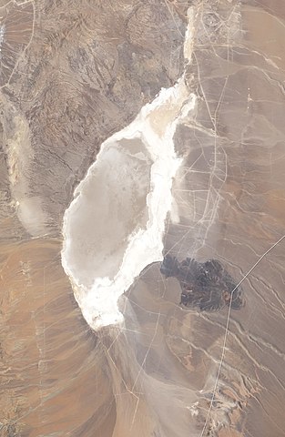
English: Natural-colour image of Parque Nacional Llullaillaco. Some snow and ice linger on the slopes of Llullaillaco, but little vegetation appears in this landscape. The clearest patch of green occurs in a lake east of the park. This landscape is a combination of mostly bare peaks and salt pans—the large, nearly white areas south and west of the volcano. |
| Date | |
| Source | NASA Earth Observatory |
| Author | Robert Simmon |
| Other versions |

.jpg&action=edit§ion=1)
Image captured by the Enhanced Thematic Mapper Plus on the Landsat 7 satellite. Landsat data provided by the United States Geological Survey.
Licensing[edit]
.jpg&action=edit§ion=2)
| This file is in the public domain in the United States because it was solely created by NASA. NASA copyright policy states that "NASA material is not protected by copyright unless noted". (See Template:PD-USGov, NASA copyright policy page or JPL Image Use Policy.) | ||
 |
Warnings:
|
| Annotations | This image is annotated: View the annotations at Commons |
.jpg)
File history
Click on a date/time to view the file as it appeared at that time.
| Date/Time | Thumbnail | Dimensions | User | Comment | |
|---|---|---|---|---|---|
| current | 17:21, 18 November 2018 | | 1,113 × 1,708 (449 KB) | Jo-Jo Eumerus (talk | contribs) | File:Parque Nacional Llullaillaco.jpg cropped 73 % horizontally, 58 % vertically using CropTool with precise mode. |
You cannot overwrite this file.
File usage on Commons
The following 2 pages use this file:
File usage on other wikis
The following other wikis use this file:
- Usage on en.wikipedia.org
- Usage on es.wikipedia.org
.jpg&oldid=704102655)