File:Pano baie Pen Hir.jpg
Jump to navigation
Jump to search
Size of this preview: 800 × 198 pixels. Other resolutions: 320 × 79 pixels | 640 × 159 pixels | 1,024 × 254 pixels | 1,280 × 317 pixels | 7,659 × 1,897 pixels.
Original file (7,659 × 1,897 pixels, file size: 18.5 MB, MIME type: image/jpeg)
Captions
Captions
Add a one-line explanation of what this file represents
Summary[edit]
| Description |
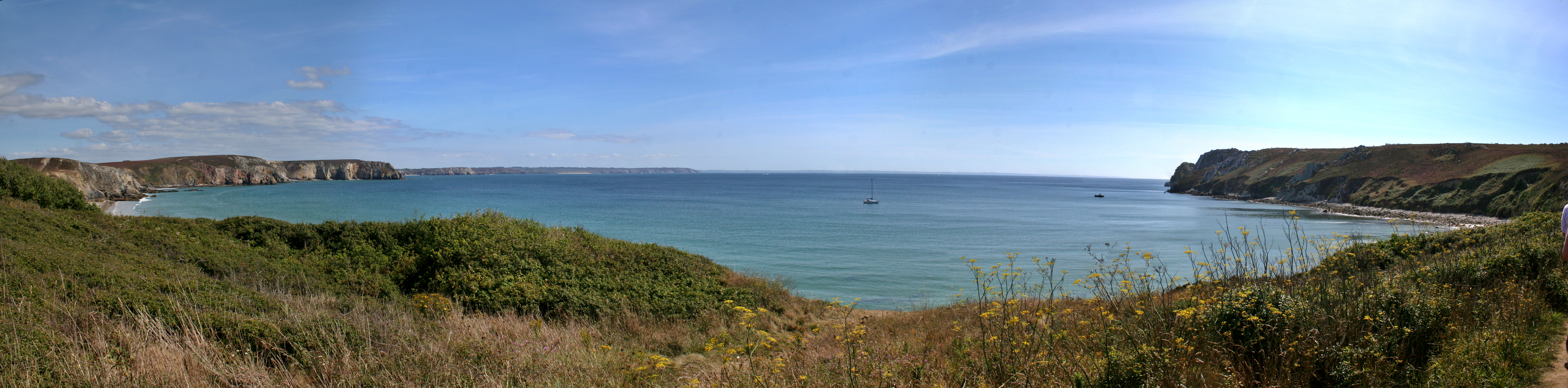
English: Panoramic view of the Pen Hir Bay taken from the path between the Veryac'h beach and the Pen Hir Point, near the town of Camaret, in the Finistère département, Brittany, France. The following features are visible from the left to the right: Veryac'h beach, Tavelle Point, Dinan bay entrance, Dinan Point, Palue beach, Chèvre's cape (Litt. "Goat's Cape"); on the horizon is the Cap Sizun peninsula, with Raz point at it's tip. On the foreground, Pen Hir point.
Français : Vue panoramique sur l'anse de Pen Hir et la mer d'Iroise prise depuis le chemin reliant la plage de Veryac'h et la pointe de Pen Hir, sur la commune de Camaret, dans le Finistère, en Bretagne (France). Sont visible, de gauche à droite : la plage de Veryac'h, la pointe de la tavelle, l'entrée de l'anse de Dinan, la pointe de Dinan, la plage de la Palue, le cap de la chèvre; puis, à l'horizon, le Cap Sizun se terminant par la pointe du raz, et enfin, au premier plan, la pointe de Pen Hir. |
| Date | |
| Source | Own work |
| Author | Berrucomons |
| Camera location | | View this and other nearby images on: OpenStreetMap |
|---|
Licensing[edit]
I, the copyright holder of this work, hereby publish it under the following licenses:
This file is licensed under the Creative Commons Attribution-Share Alike 3.0 Unported license.
- You are free:
- to share – to copy, distribute and transmit the work
- to remix – to adapt the work
- Under the following conditions:
- attribution – You must give appropriate credit, provide a link to the license, and indicate if changes were made. You may do so in any reasonable manner, but not in any way that suggests the licensor endorses you or your use.
- share alike – If you remix, transform, or build upon the material, you must distribute your contributions under the same or compatible license as the original.

|
Permission is granted to copy, distribute and/or modify this document under the terms of the GNU Free Documentation License, Version 1.2 or any later version published by the Free Software Foundation; with no Invariant Sections, no Front-Cover Texts, and no Back-Cover Texts. A copy of the license is included in the section entitled GNU Free Documentation License. |
You may select the license of your choice.
| Annotations | This image is annotated: View the annotations at Commons |
File history
Click on a date/time to view the file as it appeared at that time.
| Date/Time | Thumbnail | Dimensions | User | Comment | |
|---|---|---|---|---|---|
| current | 21:07, 11 November 2011 | 7,659 × 1,897 (18.5 MB) | Berrucomons (talk | contribs) | {{Information |Description ={{en|1=Panoramic view of the Pen Hir Bay taken from the path between the Veryac'h beach and the Pen Hir Point, near the town of Camaret, in the Finistère ''département'', Brittany, France. The following features are visibl |
You cannot overwrite this file.
File usage on Commons
The following 2 pages use this file:
File usage on other wikis
The following other wikis use this file:
- Usage on ceb.wikipedia.org
- Usage on www.wikidata.org