File:Pano Saint Etienne Ouest Deschanel.jpg

Original file (40,454 × 5,430 pixels, file size: 22.84 MB, MIME type: image/jpeg)
Captions
Captions
Summary[edit]
| Warning | The original file is very high-resolution. It might not load properly or could cause your browser to freeze when opened at full size. |
|---|
| Description |
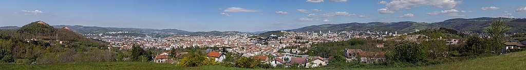
Français : Panoramique à 180° réalisé depuis le boulevard Deschanel, à l'ouest de Saint-Étienne, Loire.
De gauche à droite on voit : les crassiers de Michon, le stade Geoffroy-Guichard, le Zénith, le chevalement du Puits Coriot, le toit de l'Hôtel de Ville et le clocher de l'Église Saint-Charles, les immeubles caractéristiques du quartier de Tarentaize, les clochers de Saint-Ennemond et de l'église Boivin, la masse de l'ancienne Sécurité Sociale, l'église des Pères, l'Opéra-Théâtre, l'ancien bâtiment de Manufrance, aujourd'hui Chambre de commerce et d'industrie, et, tout au fond à droite, les bâtiments du quartier de Beaulieu. À l'arrière-plan, au centre, les toits d'Ikea et le chantier du futur centre commercial du Pont de l'Âne, à droite, le relai du Guizet.
English: 180° Panoramic made from Boulevard Deschanel, west of Saint-Etienne, Loire.
From left to right we can see: the crassiers de Michon, the Geoffroy-Guichard stadium, the Zenith, the head of the Coriot Well, the roof of the Hôtel de Ville and the bell tower of the Saint-Charles Church, the characteristic buildings of the district of Tarentaize, the bell towers of Saint-Ennemond and the Boivin church, the mass of the old Social Security, the Church of the Fathers, the Opera-Theater, the old building of Manufrance, today House of trade and industry, and, at the far right, the buildings of the Beaulieu district. In the background, in the center, the roofs of Ikea and the building site of the future shopping center Pont de l'Âne, on the right, the relay of Guizet. |
| Date | |
| Source | Own work |
| Author | Hélène Rival |
| Permission (Reusing this file) |
This file is licensed under the Creative Commons Attribution-Share Alike 4.0 International license. Attribution: Wikimedia Commons : Hélène Rival
|
| Camera location | | View this and other nearby images on: OpenStreetMap |
|---|

|
NOTE: This image is a panorama consisting of multiple frames that were merged or stitched in software. As a result, this image necessarily underwent some form of digital manipulation. These manipulations may include blending, blurring, cloning, and colour and perspective adjustments. As a result of these adjustments, the image content may be slightly different from reality at the points where multiple images were combined. This manipulation is often required due to lens, perspective, and parallax distortions.
|
This image has been assessed using the Quality image guidelines and is considered a Quality image.
|
File history
Click on a date/time to view the file as it appeared at that time.
| Date/Time | Thumbnail | Dimensions | User | Comment | |
|---|---|---|---|---|---|
| current | 12:43, 14 May 2019 | 40,454 × 5,430 (22.84 MB) | MirandaAdramin (talk | contribs) | Fichier plus léger. | |
| 12:19, 14 May 2019 | 40,454 × 5,430 (48.94 MB) | MirandaAdramin (talk | contribs) | User created page with UploadWizard |
You cannot overwrite this file.
File usage on Commons
The following 4 pages use this file: