File:Pannonia secunda.png
Jump to navigation
Jump to search
Size of this preview: 800 × 487 pixels. Other resolutions: 320 × 195 pixels | 640 × 390 pixels | 1,034 × 630 pixels.
Original file (1,034 × 630 pixels, file size: 49 KB, MIME type: image/png)
Captions
Captions
Add a one-line explanation of what this file represents
Summary[edit]
| Description |
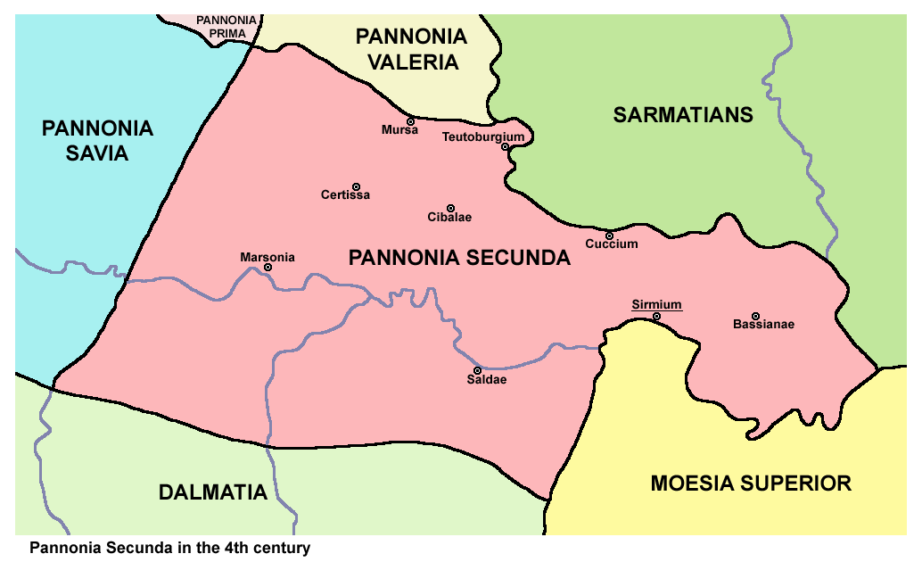
English: Historic map of Roman province Pannonia Secunda, 4th century. Српски / srpski: Историјска мапа римске провинције Друга Панонија, 4. век. |
| Date | 26 May 2006 (original upload date) |
| Source | Transferred from en.wikipedia to Commons. |
| Author | Original uploader and author was PANONIAN at en.wikipedia |
Licensing[edit]
self made map by user:PANONIAN
| This work has been released into the public domain by its author, PANONIAN at English Wikipedia. This applies worldwide. In some countries this may not be legally possible; if so: PANONIAN grants anyone the right to use this work for any purpose, without any conditions, unless such conditions are required by law. |
References[edit]
- Sima M. Ćirković, Srbi među evropskim narodima, Beograd, 2004.
- Dragan Brujić, Vodič kroz svet Vizantije, Beograd, 2004.
- Denis Šehić - Demir Šehić, Istorijski atlas sveta, Beograd, 2007.
- Petar Milošević, Arheologija i istorija Sirmijuma, Novi Sad, 2001.
- Zbornik "Vojvodina", knjiga I, Fototipsko izdanje, PROMETEJ, Novi Sad, 2008.
- Radomir Popović, Rano hrišćanstvo u Panoniji, Vojvođanski godišnjak, sveska I, Novi Sad, 1995.
- http://xxlworld.xx.ohost.de/povijest/slike/mape/3-5cen.jpg[dead link]
- http://www.euratlas.net/history/europe/300/index.html
- http://www.geocities.ws/lajme8reja/1111111111dardania.JPG
- http://www.orbilat.com/Maps/Latin/Balkan_Latin.gif
- http://www.pecs.egyhazmegye.hu/images080812/egyhazmegye_rovod_tortenete/pannonia_4_nagy.jpg
Original upload log[edit]
The original description page was here. All following user names refer to en.wikipedia.
- 2006-05-26 00:20 PANONIAN 768×440×8 (23829 bytes)
File history
Click on a date/time to view the file as it appeared at that time.
| Date/Time | Thumbnail | Dimensions | User | Comment | |
|---|---|---|---|---|---|
| current | 17:33, 7 January 2014 | | 1,034 × 630 (49 KB) | PANONIAN (talk | contribs) | aesthetics |
| 16:41, 5 July 2011 |  | 1,033 × 630 (49 KB) | PANONIAN (talk | contribs) | improved version | |
| 13:54, 9 April 2008 |  | 768 × 440 (23 KB) | File Upload Bot (Magnus Manske) (talk | contribs) | {{BotMoveToCommons|en.wikipedia}} {{Information |Description={{en|historic map (self made) en:Category:Maps of the history of Vojvodina en:Category:Maps of the history of Serbia en:Category:Maps of the history of Croatia [[:en:Category:Ma |
You cannot overwrite this file.
File usage on Commons
The following page uses this file:
File usage on other wikis
The following other wikis use this file:
- Usage on az.wikipedia.org
- Usage on ba.wikipedia.org
- Usage on be.wikipedia.org
- Usage on bg.wikipedia.org
- Usage on ca.wikipedia.org
- Usage on el.wikipedia.org
- Usage on en.wikipedia.org
- Usage on fa.wikipedia.org
- Usage on fr.wikipedia.org
- Usage on gl.wikipedia.org
- Usage on hr.wikipedia.org
- Usage on it.wikipedia.org
- Usage on ja.wikipedia.org
- Usage on ka.wikipedia.org
- Usage on lt.wikipedia.org
- Usage on mk.wikipedia.org
- Usage on ro.wikipedia.org
- Usage on ru.wikipedia.org
- Usage on scn.wikipedia.org
- Usage on sh.wikipedia.org
- Usage on sl.wikipedia.org
- Usage on uk.wikipedia.org