File:Pam Islands (Landsat).JPG
Jump to navigation
Jump to search
No higher resolution available.
Pam_Islands_(Landsat).JPG (276 × 197 pixels, file size: 16 KB, MIME type: image/jpeg)
Captions
Captions
Add a one-line explanation of what this file represents
Summary[edit]
.JPG&action=edit§ion=1)
| Description |
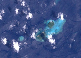
English: This image (Landsat 7) shows the Pam Islands, Bismarck Archipelago, Admirality Islands Group, Papua New Guinea. |
| Date | |
| Source | http://oceancolor.gsfc.nasa.gov/cgi/landsat_extract.pl?path=97&row=62&x=3343&y=-1560&n=0&t=321 |
| Author | NASA |
Licensing[edit]
.JPG&action=edit§ion=2)
| This file is in the public domain in the United States because it was solely created by NASA. NASA copyright policy states that "NASA material is not protected by copyright unless noted". (See Template:PD-USGov, NASA copyright policy page or JPL Image Use Policy.) | ||
 |
Warnings:
|
File history
Click on a date/time to view the file as it appeared at that time.
| Date/Time | Thumbnail | Dimensions | User | Comment | |
|---|---|---|---|---|---|
| current | 09:43, 5 April 2013 | | 276 × 197 (16 KB) | Wurfzoll (talk | contribs) | User created page with UploadWizard |
You cannot overwrite this file.
File usage on Commons
There are no pages that use this file.
File usage on other wikis
The following other wikis use this file:
- Usage on de.wikipedia.org
- Usage on fa.wikipedia.org
.JPG&oldid=678131871)