File:Palo Duro Canyon 1.jpg
Jump to navigation
Jump to search

Size of this preview: 800 × 533 pixels. Other resolutions: 320 × 213 pixels | 640 × 427 pixels | 1,024 × 683 pixels | 1,280 × 853 pixels | 2,160 × 1,440 pixels.
Original file (2,160 × 1,440 pixels, file size: 433 KB, MIME type: image/jpeg)
Captions
Captions
Add a one-line explanation of what this file represents
Summary[edit]
| Description |
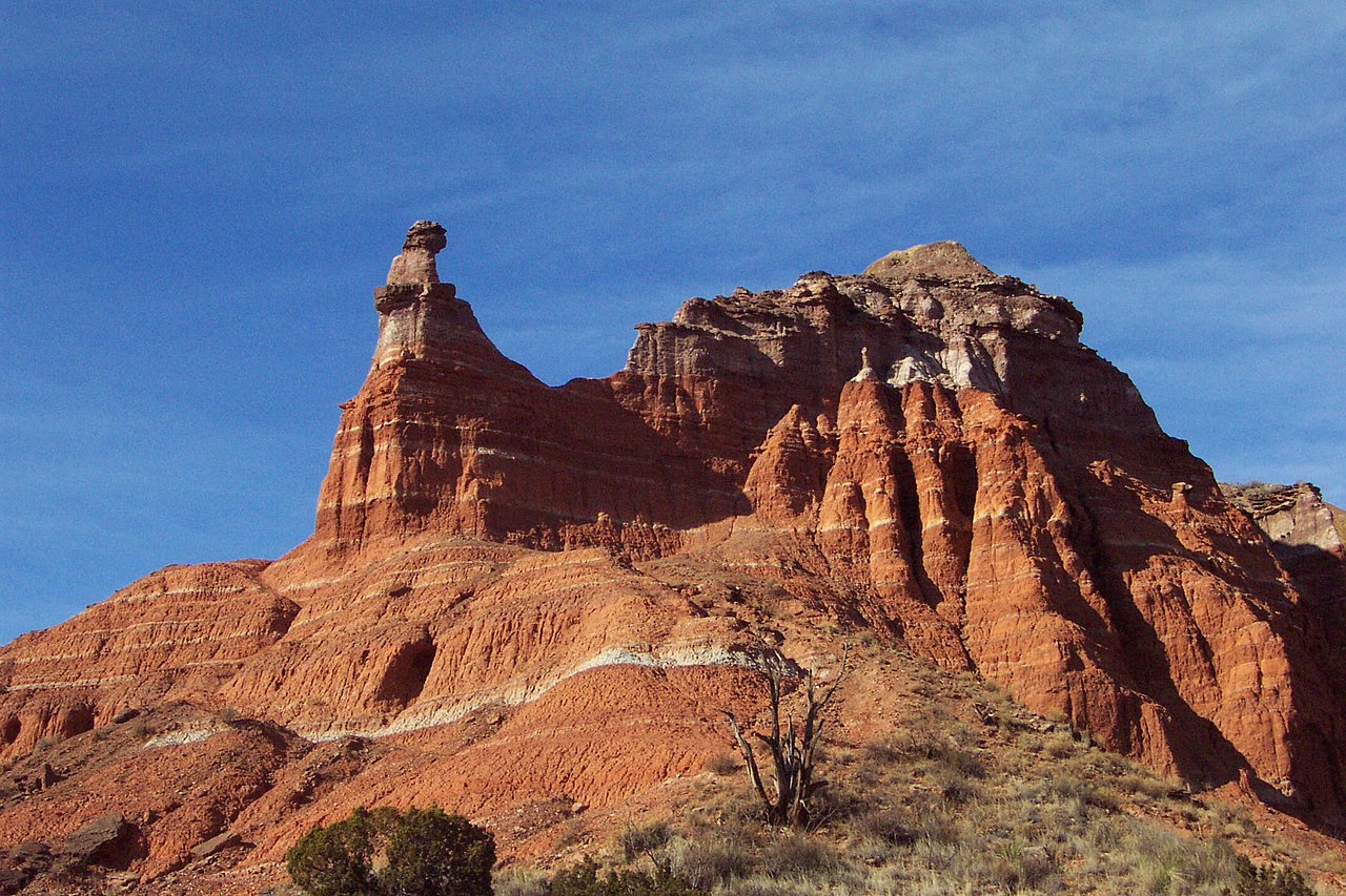
English: Capitol Peak with pillar-like erosional remnant (“hoodoo”) at the tip of its southern promontory, seen from a hiking trail at the southern foot of the mountain, northern part of Palo Duro Canyon, about 20 km SE of Amarillo, NW-Texas, USA. The terrestrial red beds exposed at Capitol Peak belong to the Quartermaster Formation of the Upper Permian, overlain by the Tecovas Formation of the Dockum Group of the Upper Triassic.[1] Both formations are easily distiguished from each other by their colouration: The beds of the Quartermaster Formation are more yellowish, whereas those of the Tecovas Formation are more bluish.
Deutsch: Capitol Peak mit Erosionspfeiler („Hoodoo“) an der Spitze seines Südausläufers, von einem Wanderweg am südlichen Fuß des Berges aus gesehen, Nordteil des Palo Duro Canyon, etwa 20 km südöstlich von Amarillo, NW-Texas, USA. Die roten terrestrischen Sedimentgesteine, die am Capitol Peak aufgeschlossen sind, gehören zur Quartermaster-Formation des oberen Perms, überlagert von der Tecovas-Formation der Dockum-Gruppe der oberen Trias.[1] Die beiden Formationen lassen sich anhand ihrer Farbtönung gut voneinander unterscheiden. Die Schichten der Quartermaster-Formation sind eher gelblich, die der Tecovas-Formation eher bläulich.
|
| Date | |
| Source | DCP_4415 |
| Author | Clinton Steeds from Los Angeles, USA |
| Camera location | | View this and other nearby images on: OpenStreetMap |
|---|
Licensing[edit]
This file is licensed under the Creative Commons Attribution 2.0 Generic license.
- You are free:
- to share – to copy, distribute and transmit the work
- to remix – to adapt the work
- Under the following conditions:
- attribution – You must give appropriate credit, provide a link to the license, and indicate if changes were made. You may do so in any reasonable manner, but not in any way that suggests the licensor endorses you or your use.
| This image was originally posted to Flickr by Clinton Steeds at https://www.flickr.com/photos/74174844@N00/46331654. It was reviewed on 7 September 2008 by FlickreviewR and was confirmed to be licensed under the terms of the cc-by-2.0. |
File history
Click on a date/time to view the file as it appeared at that time.
| Date/Time | Thumbnail | Dimensions | User | Comment | |
|---|---|---|---|---|---|
| current | 12:15, 7 September 2008 | | 2,160 × 1,440 (433 KB) | FlickreviewR (talk | contribs) | Replacing image by its original image from Flickr |
| 06:36, 7 September 2008 |  | 1,024 × 683 (537 KB) | Urban~commonswiki (talk | contribs) | {{Information |Description= Capitol Peak, along the hiking trail in Palo Duro Canyon, Texas, USA |Source=[http://www.flickr.com/photos/74174844@N00/46331654/ DCP_4415] |Date=January 06, 2004 at 10:55 |Author=[http://www.flickr.com/people/74174844@N00 Clin |
You cannot overwrite this file.
File usage on Commons
There are no pages that use this file.
File usage on other wikis
The following other wikis use this file:
- Usage on de.wikipedia.org
- Usage on fr.wikipedia.org
- Usage on pl.wikipedia.org
- Usage on uk.wikipedia.org