File:Paleogeographic maps east Asia. Turgai Sea.jpg
Jump to navigation
Jump to search

Size of this preview: 327 × 599 pixels. Other resolutions: 131 × 240 pixels | 262 × 480 pixels | 900 × 1,649 pixels.
Original file (900 × 1,649 pixels, file size: 100 KB, MIME type: image/jpeg)
Captions
Captions
Add a one-line explanation of what this file represents
Summary
[edit]
| Description |
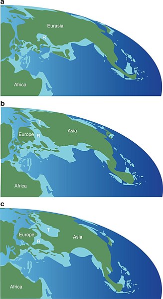
English: Paleogeographic maps showing the formation and disappearance of an epicontinental seaway between Europe and Central Asia during the Middle Jurassic through Early Cretaceous. a Middle Jurassic (170 Ma); b Late Jurassic (160 Ma); c Early Cretaceous (138 Ma). The maps are based on ref. 48. Green indicates land, light blue shallow sea, and deep blue ocean. Abbreviations: R, Russian Platform Sea; T, Turgai Sea |
| Date | |
| Source | https://www.nature.com/articles/s41467-018-05128-1 |
| Author | Xing Xu, Paul Upchurch, Philip D. Mannion, Paul M. Barrett, Omar R. Regalado-Fernandez, Jinyou Mo, Jinfu Ma & Hongan Liu |
Licensing
[edit]
This file is licensed under the Creative Commons Attribution 4.0 International license.
- You are free:
- to share – to copy, distribute and transmit the work
- to remix – to adapt the work
- Under the following conditions:
- attribution – You must give appropriate credit, provide a link to the license, and indicate if changes were made. You may do so in any reasonable manner, but not in any way that suggests the licensor endorses you or your use.
File history
Click on a date/time to view the file as it appeared at that time.
| Date/Time | Thumbnail | Dimensions | User | Comment | |
|---|---|---|---|---|---|
| current | 16:08, 1 August 2018 | | 900 × 1,649 (100 KB) | Levi bernardo (talk | contribs) | User created page with UploadWizard |
You cannot overwrite this file.
File usage on Commons
There are no pages that use this file.
File usage on other wikis
The following other wikis use this file:
- Usage on es.wikipedia.org
- Usage on zh.wikipedia.org