File:Pakistan population density.png
Jump to navigation
Jump to search
Size of this preview: 640 × 599 pixels. Other resolutions: 256 × 240 pixels | 820 × 768 pixels | 1,094 × 1,024 pixels | 2,187 × 2,048 pixels | 5,400 × 5,056 pixels.
Original file (5,400 × 5,056 pixels, file size: 1.88 MB, MIME type: image/png)
Captions
Captions
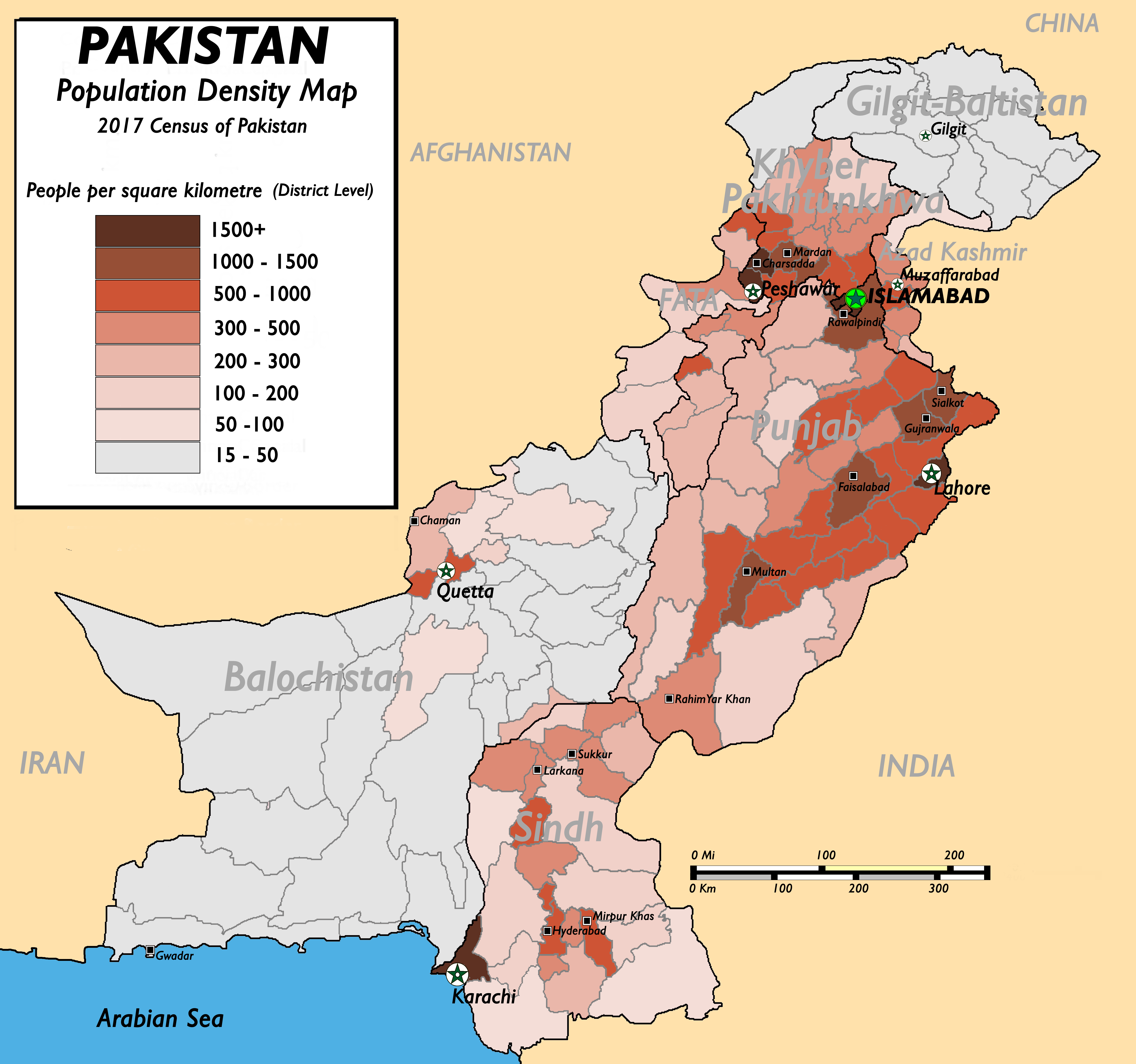
Population density of Pakistan

|
This file has been superseded by Population Density by Pakistani District - 2017 Census.SVG. It is recommended to use the other file. Please note that deleting superseded images requires consent. Reason to use the other file: "SVG File that uses a better template, is more detailed, and fixes many errors"
|
new file |
Summary[edit]
| Description |
English: Pakistan Population Density Map (English). (Abbreviations used: 1. NWFP = North West Frontier Province, 2. FATA = Federally Administered Tribal Areas.) |
| Date | 13 August 2009 (original upload date) |
| Source |
(New version uploaded by using data from 2017 Pakistan Population Census, Official Website (Original text: I created this work by myself with the sources of World Trade Press and Population census organisation, Government of Pakistan.) |
| Author | nomi887 (talk) |
Licensing[edit]
Nomi887 at English Wikipedia, the copyright holder of this work, hereby publishes it under the following licenses:
This file is licensed under the Creative Commons Attribution-Share Alike 3.0 Unported license.
Attribution: Nomi887 at English Wikipedia
- You are free:
- to share – to copy, distribute and transmit the work
- to remix – to adapt the work
- Under the following conditions:
- attribution – You must give appropriate credit, provide a link to the license, and indicate if changes were made. You may do so in any reasonable manner, but not in any way that suggests the licensor endorses you or your use.
- share alike – If you remix, transform, or build upon the material, you must distribute your contributions under the same or compatible license as the original.

|
Permission is granted to copy, distribute and/or modify this document under the terms of the GNU Free Documentation License, Version 1.2 or any later version published by the Free Software Foundation; with no Invariant Sections, no Front-Cover Texts, and no Back-Cover Texts. A copy of the license is included in the section entitled GNU Free Documentation License. |
You may select the license of your choice.
Original upload log[edit]
The original description page was here. All following user names refer to en.wikipedia.
- 2009-08-13 11:22 Brainlara73 1357×1348× (210478 bytes) Reverted to version as of 11:06, 13 August 2009
- 2009-08-13 11:07 Brainlara73 1357×1348× (210478 bytes) location corrected
- 2009-08-13 11:06 Brainlara73 1357×1348× (210478 bytes) location corrected
- 2009-08-13 09:57 Nomi887 1357×1348× (235717 bytes) More scrutinized version.
- 2009-07-07 11:18 Brainlara73 1361×1390× (195660 bytes) Added Jhelum in Punjab
- 2009-06-11 09:46 Nomi887 1361×1390× (212195 bytes) {{Information |Description = Pakistan Population Density Map (English). |Source = I created this work by myself with the sources of [http://www.bestcountryreports.com/Population_Map_Pakistan.html World Trade Press] and [http://www.statpak.gov
File history
Click on a date/time to view the file as it appeared at that time.
| Date/Time | Thumbnail | Dimensions | User | Comment | |
|---|---|---|---|---|---|
| current | 12:43, 17 December 2018 | | 5,400 × 5,056 (1.88 MB) | Nomi887 (talk | contribs) | New version as per Pakistan Population Census of 2017 by using data from #REDIRECTCensus Data, Pakistan Bureau of Statistics |
| 07:57, 11 April 2011 |  | 1,389 × 1,383 (220 KB) | Nomi887 (talk | contribs) | minor corrections in locations and density | |
| 17:35, 18 March 2010 |  | 1,357 × 1,348 (206 KB) | Ranveig (talk | contribs) | {{Information |Description={{en|Pakistan Population Density Map (English). ''(Abbreviations used: 1. NWFP = North West Frontier Province, 2. FATA = Federally Administered Tribal Areas.)''}} |Source=Transferred from [http://en.wikipedia.org en.wikipedia]<b |
You cannot overwrite this file.
File usage on Commons
There are no pages that use this file.
File usage on other wikis
The following other wikis use this file:
- Usage on ba.wikipedia.org
- Usage on bn.wikipedia.org
- Usage on bs.wikipedia.org
- Usage on de.wikipedia.org
- Usage on diq.wikipedia.org
- Usage on en.wikipedia.org
- Usage on fr.wikipedia.org
- Usage on fr.wikinews.org
- Usage on hu.wikipedia.org
- Usage on inh.wikipedia.org
- Usage on io.wikipedia.org
- Usage on ja.wikipedia.org
- Usage on mr.wikipedia.org
- Usage on nl.wikipedia.org
- Usage on nl.wikinews.org
- Usage on nn.wikipedia.org
- Usage on no.wikipedia.org
- Usage on pnb.wikipedia.org
- Usage on pt.wikipedia.org
- Usage on ru.wikipedia.org
- Usage on th.wikipedia.org
- Usage on uk.wikipedia.org
- Usage on ur.wikipedia.org
- Usage on vi.wikipedia.org
- Usage on zh.wikipedia.org