File:Pakistan Nationalhighways.PNG
Jump to navigation
Jump to search

Size of this preview: 625 × 600 pixels. Other resolutions: 250 × 240 pixels | 500 × 480 pixels | 800 × 768 pixels | 1,067 × 1,024 pixels | 2,134 × 2,048 pixels | 3,256 × 3,125 pixels.
Original file (3,256 × 3,125 pixels, file size: 1.09 MB, MIME type: image/png)
Captions
Captions
Add a one-line explanation of what this file represents

|
This map image could be re-created using vector graphics as an SVG file. This has several advantages; see Commons:Media for cleanup for more information. If an SVG form of this image is available, please upload it and afterwards replace this template with
{{vector version available|new image name}}.
It is recommended to name the SVG file “Pakistan Nationalhighways.svg”—then the template Vector version available (or Vva) does not need the new image name parameter. |
Summary[edit]
| Description |
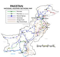
English: National Highways, Motorways & Strategic Roads in Pakistan. (Longest route N-5, from Karachi to Torkham, covering cities of Hyderabad, Multan, Lahore, Rawalpindi and Peshawar with a total length of 1,756 kilometers.) Русский: Схема национальных автодорог, автомагистралей и стратегических дорог Пакистана |
| Date | Uploaded in June 2009 by Nomi887; modified in July 2009 by Brainlara73. |
| Source | The English language Wikipedia. Original text: Self made using [1] and [2] as reference. |
| Author | Original text: nomi887 (talk) |
![[1]](http://www.daleelteq.com.pk/images/maps/Highway%20&%20Motorway%20Network%20of%20Pakistan.jpg)
Licensing[edit]
This file is licensed under the Creative Commons Attribution-Share Alike 3.0 Unported license.
Attribution: Nomi887
- You are free:
- to share – to copy, distribute and transmit the work
- to remix – to adapt the work
- Under the following conditions:
- attribution – You must give appropriate credit, provide a link to the license, and indicate if changes were made. You may do so in any reasonable manner, but not in any way that suggests the licensor endorses you or your use.
- share alike – If you remix, transform, or build upon the material, you must distribute your contributions under the same or compatible license as the original.
Original upload log[edit]
All usernames refer to en:Wikipedia (log):
- 11:08, 7 July 2009 Brainlara73 uploaded a new version of "File:Pakistan Nationalhighways.PNG" 1,354×1,316 (246 KB) (Added some more locations in punjab.)
- 04:53, 17 June 2009 Nomi887 uploaded "File:Pakistan Nationalhighways.PNG" 1,354×1,316 (292 KB) ({{Information |Description = National Highways, Motorways & Strategic Roads in Pakistan |Source = Self made using [http://www.daleelteq.com.pk/images/maps/Highway%20&%20Motorway%20Network%20of%20Pakistan.jpg] and [http://www.nhmp.gov.pk/mapm.)
File history
Click on a date/time to view the file as it appeared at that time.
| Date/Time | Thumbnail | Dimensions | User | Comment | |
|---|---|---|---|---|---|
| current | 15:18, 1 January 2019 | | 3,256 × 3,125 (1.09 MB) | Pakieditor (talk | contribs) | Reverted to version as of 12:05, 26 June 2012 (UTC) |
| 15:15, 1 January 2019 |  | 1,125 × 1,080 (553 KB) | Pakieditor (talk | contribs) | More detailed map. | |
| 12:05, 26 June 2012 |  | 3,256 × 3,125 (1.09 MB) | Nomi887 (talk | contribs) | Corrected. | |
| 09:51, 14 February 2011 |  | 1,354 × 1,316 (326 KB) | Nomi887 (talk | contribs) | Minor corrections | |
| 09:40, 14 February 2011 |  | 1,354 × 1,316 (325 KB) | Nomi887 (talk | contribs) | Added Expressways & logos. | |
| 00:00, 7 January 2010 |  | 1,354 × 1,316 (246 KB) | Guillaume70 (talk | contribs) | {{Information |Description=National Highways, Motorways & Strategic Roads in Pakistan. (Longest route N-5, from Karachi to Torkham, covering cities of Hyderabad, Multan, Lahore, Rawalpindi and Peshawar with a total length of 1819 kilometers.) |Source=Wiki |
You cannot overwrite this file.
File usage on Commons
The following 2 pages use this file:
File usage on other wikis
The following other wikis use this file:
- Usage on bn.wikipedia.org
- Usage on cs.wikipedia.org
- Usage on de.wikipedia.org
- Usage on de.wikivoyage.org
- Usage on en.wikipedia.org
- Transport in Pakistan
- Controlled-access highway
- Indus Highway
- National highways of Pakistan
- N-5 National Highway
- Motorways of Pakistan
- N-25 National Highway
- User:Nomi887
- Expressways of Pakistan
- N-50 National Highway
- N-30 National Highway
- N-40 National Highway
- N-45 National Highway
- N-65 National Highway
- N-70 National Highway
- N-75 National Highway
- N-85 National Highway
- N-80 National Highway
- N-90 National Highway
- N-95 National Highway
- N-105 National Highway
- N-110 National Highway
- N-120 National Highway
- N-125 National Highway
- N-155 National Highway
- N-255 National Highway
- N-305 National Highway
- N-455 National Highway
- N-655 National Highway
- Roads in Pakistan
- Template talk:Portal/Archive 8
- Usage on en.wikivoyage.org
- Usage on eo.wikipedia.org
View more global usage of this file.