File:Pakistan KPK FATA areas with localisation map.svg
(Redirected from File:Pakistan NWFP FATA areas with localisation map.svg)

Size of this PNG preview of this SVG file: 558 × 600 pixels. Other resolutions: 223 × 240 pixels | 446 × 480 pixels | 714 × 768 pixels | 953 × 1,024 pixels | 1,905 × 2,048 pixels | 1,000 × 1,075 pixels.
Original file (SVG file, nominally 1,000 × 1,075 pixels, file size: 243 KB)
Captions
Captions
Add a one-line explanation of what this file represents
| Description |
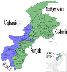
English: Map showing the districts of the Federally Administered Tribal Areas (FATA) FATA and the North-West Frontier Province (NWFP) of Pakistan.
Español: Mapa de las provincias y territorios de Pakistán
Français : Carte des régions tribales du Pakistan (FATA) et de la province voisine de Khyber Pakhtunkhwa (KPK) |
| Date | (UTC) |
| Source |
|
| Author |
|
| Other versions |
Derivative works of this file: |

|
This SVG file contains embedded text that can be translated into your language, using any capable SVG editor, text editor or the SVG Translate tool. For more information see: About translating SVG files. |
I, the copyright holder of this work, hereby publish it under the following licenses:

|
Permission is granted to copy, distribute and/or modify this document under the terms of the GNU Free Documentation License, Version 1.2 or any later version published by the Free Software Foundation; with no Invariant Sections, no Front-Cover Texts, and no Back-Cover Texts. A copy of the license is included in the section entitled GNU Free Documentation License. |
| This file is licensed under the Creative Commons Attribution-Share Alike 3.0 Unported license. | ||
| ||
| This licensing tag was added to this file as part of the GFDL licensing update. |
This file is licensed under the Creative Commons Attribution-Share Alike 2.5 Generic, 2.0 Generic and 1.0 Generic license.
- You are free:
- to share – to copy, distribute and transmit the work
- to remix – to adapt the work
- Under the following conditions:
- attribution – You must give appropriate credit, provide a link to the license, and indicate if changes were made. You may do so in any reasonable manner, but not in any way that suggests the licensor endorses you or your use.
- share alike – If you remix, transform, or build upon the material, you must distribute your contributions under the same or compatible license as the original.
You may select the license of your choice.
File history
Click on a date/time to view the file as it appeared at that time.
| Date/Time | Thumbnail | Dimensions | User | Comment | |
|---|---|---|---|---|---|
| current | 19:22, 16 May 2010 | | 1,000 × 1,075 (243 KB) | Pethrus (talk | contribs) | Added district borders |
| 11:13, 16 May 2010 |  | 1,000 × 1,075 (238 KB) | Pethrus (talk | contribs) | Corrected NWFP -> KPK name, added blue districts borders | |
| 16:55, 15 May 2010 |  | 1,000 × 1,075 (231 KB) | Pethrus (talk | contribs) | {{Information |Description={{en|Map showing the districts of the Federally Administered Tribal Areas (FATA) FATA and the North-West Frontier Province (NWFP) of Pakistan.}} {{es|Mapa de las provincias y territorios de Pakistán}} {{fr|Carte des [[:fr:Régi |
You cannot overwrite this file.
File usage on Commons
The following 19 pages use this file:
- File:NWPF FATA ORAKZAI.svg
- File:Pakistan NWFP FATA Bajaur.svg
- File:Pakistan NWFP FATA Khyber.svg
- File:Pakistan NWFP FATA Kurram.svg
- File:Pakistan NWFP FATA Mohmand.svg
- File:Pakistan NWFP FATA NORTH WAZIRISTAN.svg
- File:Pakistan NWFP FATA South Waziristan.svg
- File:Pakistan NWFP FATA areas with localisation map.svg (file redirect)
- File:Provinces and territories of Pakistan named es.svg
- File:Pakistan NWFP FATA areas with localisation map de.svg
- File:NWPF FATA ORAKZAI.svg
- File:Pakistan NWFP FATA NORTH WAZIRISTAN.svg
- File:Pakistan NWFP FATA South Waziristan.svg
- File:Pakistan NWFP FATA Kurram.svg
- File:Pakistan NWFP FATA Khyber.svg
- File:Pakistan NWFP FATA Bajaur.svg
- File:Pakistan NWFP FATA Mohmand.svg
- File:Pakistan NWFP FATA areas with localisation map de.svg
- File:Provinces and territories of Pakistan named es.svg
File usage on other wikis
The following other wikis use this file:
- Usage on en.wikipedia.org
- Usage on fr.wikipedia.org