File:Pakistan-Waziristan-Map 2.png
Jump to navigation
Jump to search

Size of this preview: 606 × 599 pixels. Other resolutions: 243 × 240 pixels | 486 × 480 pixels | 700 × 692 pixels.
Original file (700 × 692 pixels, file size: 94 KB, MIME type: image/png)
Captions
Captions
Add a one-line explanation of what this file represents
Summary[edit]
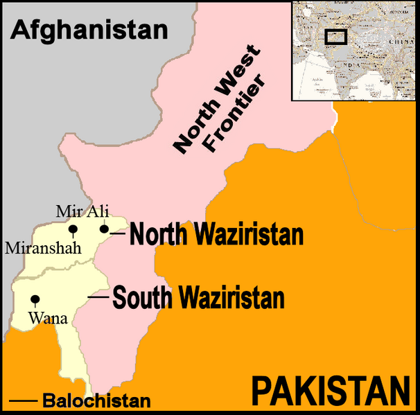
| Description | Map showing location of North and South Waziristan in northern Pakistan and bordering on Afghanistan |
| Date | |
| Source | http://commons.wikimedia.org/wiki/Image:Pakistan-Waziristan-Map.png, PD |
| Author | Thaddeus P. Bejnar and David Orlović |
Licensing[edit]
| I, the copyright holder of this work, release this work into the public domain. This applies worldwide. In some countries this may not be legally possible; if so: I grant anyone the right to use this work for any purpose, without any conditions, unless such conditions are required by law. |
File history
Click on a date/time to view the file as it appeared at that time.
| Date/Time | Thumbnail | Dimensions | User | Comment | |
|---|---|---|---|---|---|
| current | 14:37, 10 October 2007 | | 700 × 692 (94 KB) | Orlovic (talk | contribs) | == Summary == {{Information |Description=Map showing location of North and South Waziristan in northern Pakistan and bordering on Afghanistan |Source=http://commons.wikimedia.org/wiki/Image:Pakistan-Waziristan-Map.png, PD |Date=2007 |Author=Thaddeus P. Be |
You cannot overwrite this file.
File usage on Commons
There are no pages that use this file.
File usage on other wikis
The following other wikis use this file:
- Usage on bg.wikipedia.org
- Usage on de.wikinews.org
- Usage on en.wikinews.org
- Usage on pl.wikipedia.org
- Usage on ps.wikipedia.org
- Usage on ru.wikipedia.org
- Usage on uk.wikipedia.org
- Usage on www.wikidata.org