File:PacOceanAreaWWII.gif
Jump to navigation
Jump to search

Size of this preview: 711 × 599 pixels. Other resolutions: 285 × 240 pixels | 569 × 480 pixels | 1,000 × 843 pixels.
Original file (1,000 × 843 pixels, file size: 54 KB, MIME type: image/gif)
Captions
Captions
Add a one-line explanation of what this file represents
Summary[edit]
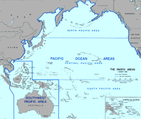
Pacific Ocean area divided up into WWII Allied command areas. http://www.army.mil/cmh-pg/books/wwii/GuadC/GC-fm.htm.
Licensing[edit]
This file is a work of a U.S. Army soldier or employee, taken or made as part of that person's official duties. As a work of the U.S. federal government, it is in the public domain in the United States.
|
 |
File history
Click on a date/time to view the file as it appeared at that time.
| Date/Time | Thumbnail | Dimensions | User | Comment | |
|---|---|---|---|---|---|
| current | 17:28, 12 July 2006 | | 1,000 × 843 (54 KB) | Cla68 (talk | contribs) | Pacific Ocean divided up into WWII Allied commands. http://www.army.mil/cmh-pg/books/wwii/GuadC/GC-fm.htm |
| 17:22, 12 July 2006 |  | 1,000 × 843 (54 KB) | Cla68 (talk | contribs) | Pacific Ocean Area divided-up into World War II commands. Gen MacArthur was Southwest Pacific. South Pacific commanded Guadalcanal operation. | |
| 17:20, 12 July 2006 |  | 1,000 × 843 (54 KB) | Cla68 (talk | contribs) |
You cannot overwrite this file.
File usage on Commons
The following 11 pages use this file: