File:PR sub-basins with tributary names.jpg
Jump to navigation
Jump to search
Size of this preview: 626 × 600 pixels. Other resolutions: 251 × 240 pixels | 501 × 480 pixels | 760 × 728 pixels.
Original file (760 × 728 pixels, file size: 158 KB, MIME type: image/jpeg)
Captions
Captions
Add a one-line explanation of what this file represents
Summary[edit]
| Description |
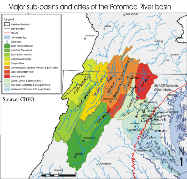
English: This map shows the watershed of the Potomac RIver, including its major tributaries. It also identifies the major tributaries by name. |
| Date | |
| Source | http://www.potomacriver.org/wp-content/uploads/2015/07/NAJ_01_Chap1.pdf |
| Author | CBPO - Chesapeake Bay Preservation Ordinance (part of EPA); and I have nmodified it by adding the names of the major tributaries of the Potomac River |
Licensing[edit]
This work is in the public domain in the United States because it is a work prepared by an officer or employee of the United States Government as part of that person’s official duties under the terms of Title 17, Chapter 1, Section 105 of the US Code.
Note: This only applies to original works of the Federal Government and not to the work of any individual U.S. state, territory, commonwealth, county, municipality, or any other subdivision. This template also does not apply to postage stamp designs published by the United States Postal Service since 1978. (See § 313.6(C)(1) of Compendium of U.S. Copyright Office Practices). It also does not apply to certain US coins; see The US Mint Terms of Use.
|
 | |
| This file has been identified as being free of known restrictions under copyright law, including all related and neighboring rights. | ||
File history
Click on a date/time to view the file as it appeared at that time.
| Date/Time | Thumbnail | Dimensions | User | Comment | |
|---|---|---|---|---|---|
| current | 11:49, 5 April 2019 | | 760 × 728 (158 KB) | P999 (talk | contribs) | I added labels for two Potomac tributaries: Broad Run (Loudon County, VA) and St Marys River (St. Mary's County, MD). |
| 13:20, 2 April 2019 |  | 760 × 728 (157 KB) | P999 (talk | contribs) | User created page with UploadWizard |
You cannot overwrite this file.
File usage on Commons
There are no pages that use this file.
File usage on other wikis
The following other wikis use this file:
- Usage on ar.wikipedia.org