File:PIA21652 - A Triple Crater.jpg

Original file (2,880 × 1,800 pixels, file size: 750 KB, MIME type: image/jpeg)
Captions
Captions
Summary[edit]
| Description |
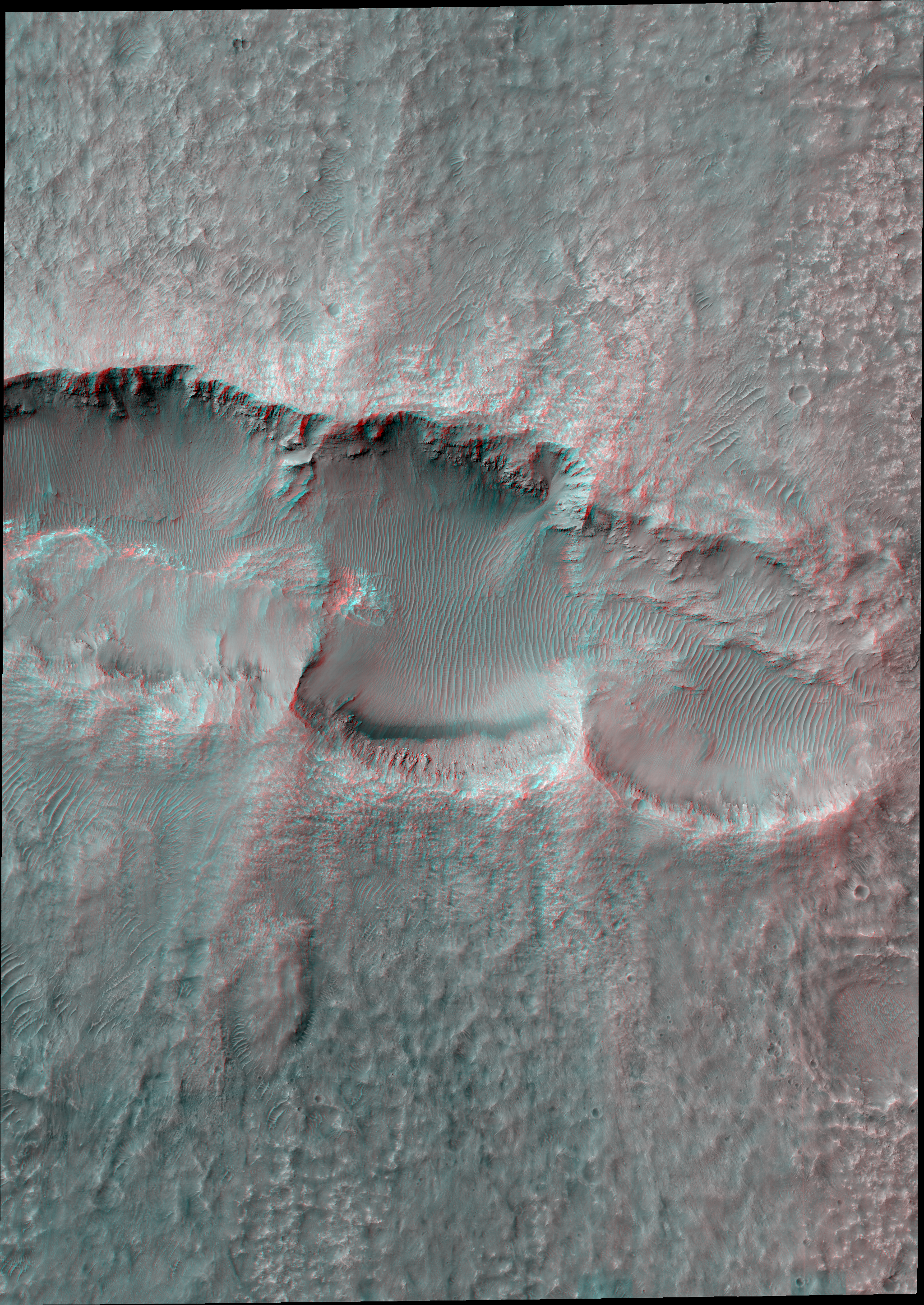
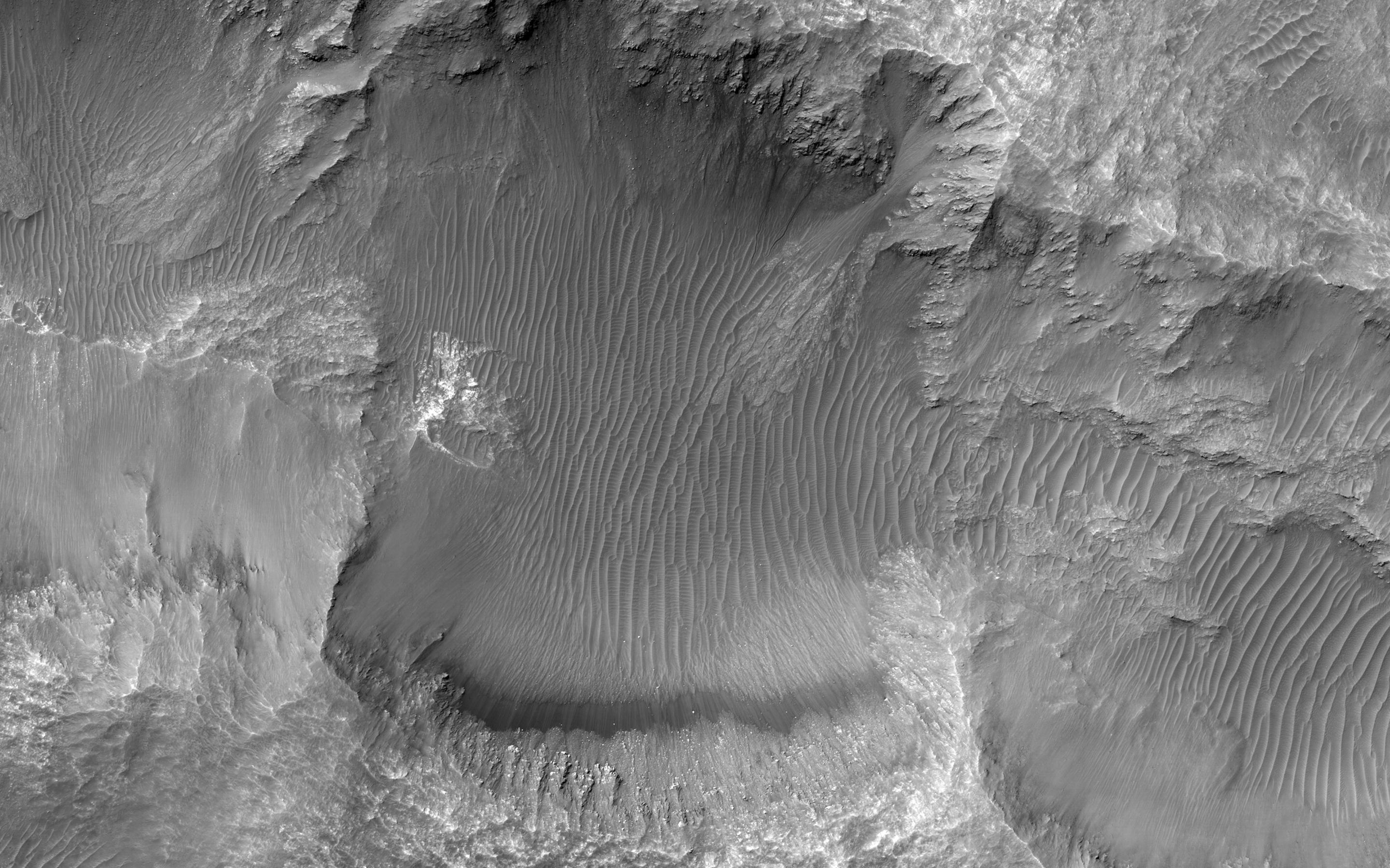
English: This image from NASA's Mars Reconnaissance Orbiter shows an elongated depression from three merged craters.
The raised rims and ejecta indicate that these are impact craters rather than collapse or volcanic landforms. The pattern made by the ejecta and the craters suggest this was a highly oblique (low angle to the surface) impact, probably coming from the west. There may have been three major pieces flying in close formation to make this triple crater. Be sure to view the anaglyph for a more detailed look. This is a stereo pair with ESP_041350_1455. The map is projected here at a scale of 25 centimeters (9.8 inches) per pixel. [The original image scale is 26.1 centimeters (10.3 inches) per pixel (with 1 x 1 binning); objects on the order of 78 centimeters (30.7 inches) across are resolved.] North is up. The University of Arizona, Tucson, operates HiRISE, which was built by Ball Aerospace & Technologies Corp., Boulder, Colo. NASA's Jet Propulsion Laboratory, a division of Caltech in Pasadena, California, manages the Mars Reconnaissance Orbiter Project for NASA's Science Mission Directorate, Washington. |
| Date | 26 March 2017 (published 1 June 2017) |
| Source | Catalog page · Full-res (JPEG · TIFF) |
| Author | NASA/JPL-Caltech/Univ. of Arizona |
| Location on Mars | View this and other nearby images on: Google Maps |
|---|
This image or video was catalogued by Jet Propulsion Laboratory of the United States National Aeronautics and Space Administration (NASA) under Photo ID: PIA21652. This tag does not indicate the copyright status of the attached work. A normal copyright tag is still required. See Commons:Licensing. Other languages:
|
 |
This media is a product of the Mars Reconnaissance Orbiter mission Credit and attribution belongs to the High Resolution Imaging Science Experiment (HiRISE) team, NASA/JPL-Caltech/Univ. of Arizona |
Licensing[edit]
| This file is in the public domain in the United States because it was solely created by NASA. NASA copyright policy states that "NASA material is not protected by copyright unless noted". (See Template:PD-USGov, NASA copyright policy page or JPL Image Use Policy.) | ||
 |
Warnings:
|
File history
Click on a date/time to view the file as it appeared at that time.
| Date/Time | Thumbnail | Dimensions | User | Comment | |
|---|---|---|---|---|---|
| current | 01:09, 2 June 2017 | | 2,880 × 1,800 (750 KB) | PhilipTerryGraham (talk | contribs) | User created page with UploadWizard |
You cannot overwrite this file.
File usage on Commons
The following page uses this file: